
Photos. Photo. System Image. OUR SYSTEMS. Skeletal System. Body Systems. System and Software Engineering. Software, Websites & operating systems. Brandieself added: Open Source Software Resources For Students - The Vuze BlogThe Vuze Blog. Photo by Is_Kyoto_Jp, Flickr Tuition, books, housing and other education-related expenses can add up quickly when you’re a student.

Finding ways to maximize an already lean budget can be challenging, as well as necessary in some instances. Fortunately, one area where expenditures can be curbed is with open source software. To clarify, open source software is often used interchangeably with public domain software, however, the two terms are not the same.
Open source is a development model that promotes open access or code free of license fees. Public domain software, on the other hand, does not have any limitations, ownership, copyright or restrictions whatsoever. For students, both open source and public domain software can alleviate some of the burden associated with commercial software prices tags. LibreOffice LibreOffice is a comprehensive, professional productivity suite that is user-friendly, high quality and simple to use. It’s 100 percent free to download and install. MARKET & TRENDS. Official Theme of Responsive Environments.
RESEARCH GROUPS. Official Theme of Responsive Environments. TECHNOLOGIES. LabCAST - The MIT Media Lab Video Podcast » Archive » #47 LuminAR. * Potion. The evolution of 3D: Hands on with Canon's new MREAL System. Wowing us with its latest promotional video, Google’s Project Glass is a hot topic.
Though they look like futuristic glasses, they’re actually an augmented reality head-mounted display that can perform many of the same functions as a smartphone, such as texting, taking and sending photos and video, and “Googling,” naturally. But Google isn’t the only one making augmented reality gadgets you wear on your head. Today, Canon announced its Mixed Reality System, or MREAL, which, though very different from Project Glass, shares many of the same principles. Imagine a world where instead of heading over to your local Best Buy to look at a potential new refrigerator, you could just put on a headset and see the fridge as if it were right in front of you – open it, walk around it, see what it looks like in different colors.
Similar markers were used in another demo that exemplified an alternative possibility for the MR System. Curious about how the MR System works exactly? Cyclotouch.com.au - Turn any LCD into touch screen. Touch Screen Panel Convert Kit. 3D Surface Reconstruction. Kinect Toolbox. Kinect the Real World to your Computer – SolidSmack. A few low-cost 3D scanners have come out recently – ReconstructMe, Matterport and 3Dfy.
These start-ups have utilized the Kinect or a Kinect-like device to make an affordable solution for modelling actual spaces and products. I was ecstatic when Microsoft released the Kinect and then the development software. It’s such a powerful hardware/software combo. It made sense that cheap, 3D scanning was just around the corner. I’m happy to see many amazing third-party applications and innovations now using this platform. Now, if you’re interested in laser scanning, particularly the DIY side of laser scanning, you’ve heard of Makerscanner and DAVID. ReconstructMe ReconstructMe is a free, non-commercial product, maintained by the good people of PROFACTOR GmbH. Matterport. Skanect creates 3D models of you and your house using Kinect sensor. Spaceplay / pause escstop.
PCL - Point Cloud Library. 3D Surface Reconstruction. SynthEyes Camera Tracker - Andersson Technologies LLC. What is SynthEyes?
SynthEyes is a Windows, Mac, or Linux software application for 3-D camera-tracking, also known as match-moving, which is widely used in film, television, commercial, and music video post-production. SynthEyes can look at the image sequence from your live-action shoot and determine how the real camera moved during the shoot, what the field of view (~focal length) was, and where various features were in 3-D, so that you can create computer-generated imagery that exactly fits into the shot.
Software systems for image-based 3D measurement. Match Photo: Modeling from photos. Creating a 3D model to match a photo Use the matching process to create a 3D model to match one or more photos of a building or structure.
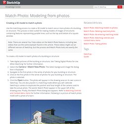
This process is best suited for making models of images of structures containing features representing parallel lines, such as the top and bottom of a square window. Note: There are several You Tube videos on the Match Photo feature, including two videos that use the same example found in this article. These videos might use an different version of SketchUp, but the process and Match Photo tools are exactly the same. Autodesk 123D - Free 3D Modeling Software, 3D Models, DIY Projects, Personal Fabrication Tools. Tools. Match Photo: Matching models to photos. Matching an existing 3D model to a photo's context Use the matching process to match an existing 3D model to a photo's context.
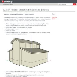
For example, you might have a model of a house that contains an addition and want to place that within a photo to show the change. To match an existing 3D model to a photo's context: Take a digital picture of the location where you will place your building. This photo might or might not have an existing building where the model will be located.Select File > Open. Select Camera > Match New Photo. Click and hold the cursor on the origin (). Using Photomatch in Google Sketchup. Strata3d.com. Insight3d - opensource image based 3d modeling software. ARC 3D. Insight3d - opensource image based 3d modeling software. ARC 3D.
ARCH 3D - Home. Structure from Motion and Archaeology. Cultural Heritage Imaging. Tgi3D. ARC 3D Webservice. Table of Contents ARC3D is a tool for creating 3D models out of a set of images.
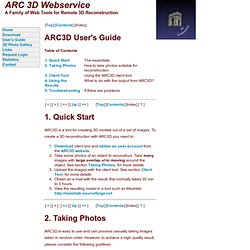
To create a 3D reconstruction with ARC3D you need to: Download client tool and obtain an user account from the ARC3D website. Take some photos of an object to reconstruct. Take many images with large overlap while moving around the object. ARC3D is easy to use and can process casually taking images taken in random order. Move between the photos. The client tool is used to upload images to the ARC3D server. 3.1 Uploading images Test connection. 3.2 Testing the connection. Automatic 3D surface fitting to photographs with Tgi3D SU PhotoScan. Systems, Inc. Before describing the operation of the V-STARS system, a brief introduction to photogrammetry is provided for those who are unfamiliar with the technology.
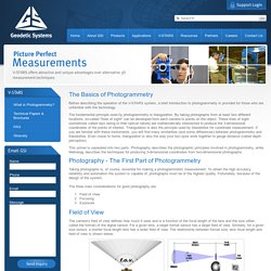
The fundamental principle used by photogrammetry is triangulation. By taking photographs from at least two different locations, so-called "lines of sight" can be developed from each camera to points on the object. These lines of sight (sometimes called rays owing to their optical nature) are mathematically intersected to produce the 3-dimensional coordinates of the points of interest. Free photogrammetric software ubuntu Download - Photogrammetric software ubuntu for Windows. Open Source Photogrammetry. Pixdim for Sketchup photogrammetry. PIXDIM, a photogrammetry measuring plugin for Google SketchUp that will transform your digital camera into a measuring device.
QUALUP SAS provides breakthrough photogrammetry technology that enhances architects, designers and engineer's productivity. Based on the established "RhinoPhoto" that is a plug-in for Rhino3D, Qualup have now expanded the range to support Google SketchUp v7. As the UK experts for RhinoPhoto, we can now help all you SketchUp users to measure and digitise your buildings into SketchUp 7/8 on a Microsoft Windows XP or Vista 32bit platform. Photogrammetrie-System. Photogrammetry – Creating 3D Digital Models with Smartphones. Emergency response can benefit from agencies having access to first-hand information. A new application developed by UNSW enables people at the scene of an emergency to scan their environment using a smartphone and receive a 3D model in seconds which they can send to the relevant authorities. The Faculty of Built Environment and College of Fine Arts have created a new application that enables people to use their Smart Phone to create a 3D model of their immediate environment.
The application is particularly beneficial in emergency situations, given that members of the public at the scene of an emergency can rapidly capture vital information and make this information available to the emergency services to improve response and recovery. Fokus GmbH Leipzig metigo 3D. Close-range photogrammetry and image-based modeling. 3D Systems Geomagic (formerly Rapidform) Products. Geomagic Products Manufacturing the Future 3D Systems Geomagic provides CAD, reverse engineering and inspection software tools and consumer 3D printers, apps and services.
Its expertly integrated solutions replace and complement traditional methods and reduce the time and cost of designing new products by printing real parts directly from digital input. These solutions are used to rapidly design, create, communicate, prototype or produce real parts, empowering customers to create and make with confidence. Comments are closed. XXII International Society for Photogrammetry & Remote Sensing Congress - Application Possibility of Smartphone as Payload for Photogrammetric UAV System. Smartphone can not only be operated under 3G network environment anytime and any place but also cost less than the existing photogrammetric UAV since it provides high-resolution image, 3D location and attitude data on a real-time basis from a variety of built-in sensors. This study is aimed to assess the feasibility of smartphone as a payload for photogrammetric UAV system. Prior to such assessment, a smartphone-based photogrammetric UAV system application was developed, through which real-time image, location and attitude data was obtained using smartphone under both static and dynamic conditions.
Subsequently the accuracy assessment on the location and attitude data obtained and sent by this system was conducted. The smartphone images were converted into ortho-images through image triangulation. The image triangulation was conducted in accordance with presence or absence of consideration of the interior orientation (IO) parameters determined by camera calibration. ISPRS Journal of Photogrammetry and Remote Sensing. Free photogrammetric digital reconstruction. EDIT: I forgot to put this here: the post below is a author’s guest post by Peter Falkingham of the School of Earth, Atmospheric and Environmental Science, University of Manchester.
Enjoy! This blog post coincides with my latest paper on open source photogrammetry software that appears in Palaeontologia Electronica yesterday. I want to briefly summarize the paper, but also to tell you about where the technology seems to be heading, and try and communicate some of my excitement. Using just a normal camera, free software, and a desktop computer,you can generate 3D digital models of everything from hand specimens, through mounted skeletons, and beyond buildings and outcrops. In the paper, I present some freely available, open source software for producing high resolution 3D models of specimens ranging from centimetre scale to outcrop scale, using photographs taken with an ordinary camera and processed on a desktop computer. Why do we want digital models? Using the GoPro Hero 3 for 3D Photogrammetry Modeling and Measuring. Using the GoPro Hero 3 for 3D Photogrammetry Modeling and Measuring Posted by Alan Walford on Mon, Sep 23, 2013 Introduction The GoPro Hero 3 is a small, lightweight, robust, low cost, and high definition video and still camera used primarily for capturing action.
The GoPro Hero 3 Black is the highest resolution version of the GoPro lineup and the one best suited to photogrammetry – the science of measurement, modeling and scanning using photographs. Due to the GoPro’s small size, low weight, wifi, and good image quality it is an interesting platform to consider for photogrammetry. This article focuses on the use of the GoPro Hero 3 Black for photogrammetry with the PhotoModeler software, and how to overcome some of the camera's deficiences.
Sensors & Systems. Sensors & Systems - 3D Laser Mapping Offers Innovative Visualisation Software. Details Jan 15 2014. Multi-Sensors and Multiray Reconstruction for Digital Preservation - 300fritsch.pdf. Sensor Fusion. Homepage Institut für Photogrammetrie. StereoScan. The Art of Photogrammetry: Introduction to Software and Hardware. Our brains perceive depth by comparing the images that our eyes see. If you alternatively close each of your eyes, you will notice that the object you see will seem to shift left and right.
Mister P. MeshLab Tutorials. Open Source Photogrammetry: Ditching 123D Catch – We Did Stuff. FARO Laser Scanner Focus3D. ARC 3D Webservice. Image Based Modeling & Photo Scanning Demos. Reality Capture For 3D Documentation. Turn photos into 3D models automatically with Smart3DCapture™ Capturing reality with automatic 3D photogrammetry software. Smart3DCapture™ applies to a variety of application areas where it dramatically enhances productivity or even opens new business opportunities. Turn photos into 3D models automatically with Smart3DCapture™ WebDLT. Mementify - Close-range photogrammetry and image-based modeling. Neo-Geography Toolkit - Stereo Pipeline Examples. The following HiRISE 3D surface models were built using the Stereo Pipeline.
We provide them here as examples of the data products that can be generated using the software. For more information about these examples, refer to the "Data Processing Examples" Appendix in the Stereo Pipeline User's Guide. 3DF Zephyr Evaluation Download Page - 3Dflow. Photogrammetry. Photogrammetry is an estimative scientific method that aims at recovering the exact positions and motion pathways of designated reference points located on any moving object, on its components and in the immediately adjacent environment.
Acute3D develops breakthrough photogrammetry software solutions to automatically turn photos into photorealistic high resolution 3D models. Match Photo: Introduction. Architectural applications « Punchcard: VideoTrace. Punchcard: VideoTrace. Match Photo: Modeling from photos. MeshLab. Is now 3D Systems Geomagic! Photogrammetrie und Computer Vision. SURE. Documents. Visual 3D Modeling from Images. Introduction. Introduction. PhotoSpace: A Vision Based Approach for Digitizing Props. Turning Mobile Phones into 3D Scanners. Enwaii photogrammetry for VFX : Making of Smurfs 2. Enwaii photogrammetry for VFX. Enwaii photogrammetry for VFX : Making of Smurfs 2. Open Source Photogrammetry. Photogrammetry plugin for Rhino. Autodesk 123D Catch. Photogrammetry in Archaeology.