
QGIS. Historical_map_of_Paris_Metro_-_1899-2012_reduced.gif 2 141 × 1 967 pixels. Geoserver. Formation. INSPIRE Conference Search Tool. Lidar. Google. TJS. Georeferencer Help Center. Eden - Espace d'information sur les groupes de travail en normalisation. Teehan+Lax Labs - Hyperlapse. Imagimap Baselayers v2. GPS. Map design: a list of helpful online resources. Whether they’ve been making maps for 20 years or two weeks, just like any designer, cartographers need inspiration when starting their latest project.
Inspiration can come from many places and take many forms. Here at Ordnance Survey we use a range of resources and we want to share some of them with you. In this post we list several online resources that can help with your latest map design; from choosing the right colour palette to selecting great fonts. Some of these resources are specific to map-making and some are more general. It is worth noting that they are not tools for making maps but tools to help with the map design process.
Although by no means a definitive list, these are some of the tools and resources that we refer to and use regularly and we have sorted them into four categories: colours, fonts, symbols and map inspiration: Colours The use of colour is very often fundamental to the success of a map.
Map Analysis online book. Google Street View, photos en continu autour d'un lieu. Google Street View inspire beaucoup les développeurs d’applications Web plus ou moins utiles : combat de robots dans votre rue, attaque d’extra-terrestres sous vos fenêtres… Sur ce site à l’interface très dépouillée, on peut à partir d’une adresse quelconque sur la planète afficher en continu les photos à proximité de cet endroit.
Dans le menu d’options on peut indiquer la distance à prendre en compte pour la présentation des photos : 2 pâtés de maisons, 1/2 mile, 1 mile, 2 miles… 10 miles. Mercator Puzzle! Using Color in Maps. Ogc smartgrid. Cadastre. GML Introduction. Introduction to GML Geography Markup Language Ron LakeGaldos Systems Inc 1.0 Introduction: This paper provides a brief introduction to Geography Markup Language (GML).
The paper is the first in a series of papers to get you acquainted with this exciting way to represent and manipulate geographic information. 2.0 What is GML ? 2.1 Status GML or Geography Markup Language is an XML based encoding standard for geographic information developed by the OpenGIS Consortium (OGC). 2.2 Geography, Graphics and Maps. GeoChat. It is designed to enable self-organizing group communications by allowing users to link the field, headquarters, and the local community in a real-time, interactive conversation visualized on the surface of a map.
GeoChat is a tool for group communications based on SMS, email, and Twitter. People use GeoChat to simplify team communications, logistics and data reporting, and they can extend their own software applications using the open APIs. GeoChat is a flexible open source group communications technology that lets team members interact to maintain shared geospatial awareness of who is doing what where — over any device, on any platform, over any network. GeoChat allows you and your team to stay in touch one another in a variety of ways: over SMS, over email, and on the surface of a map in a web browser. GeoChat is proven in the field, is simple to use, and scales with your needs. Table des titres, sections, chapitres. Les WPS, le mariage du calcul scientifique et de la géomatique - geOrchestra. Esri Maps for Office - Welcome. SERTIT. Un service de cartographie d’urgence par satellite 24 heures par jour et sept jours sur sept pour lutter contre les inondations.
About INDIGO-i Tactical Analysis 3D Modeling Software for Risk Reduction. GeoRSS sur geonetwork. Loading GeoRSS-Feeds with Dynamic Modules in the Bing Maps AJAX Control v7. Introduction In May several Updates have been released to the Bing Maps AJAX Control v7 which Keith Kinnan has summarized here. Possibly the most significant one is the ability to dynamically load additional modules. When the Bing Maps AJAX Control had been re-written for v7 some of the design goals had been to improve performance and to support mobile devices. In order to achieve these goals the Bing Maps AJAX control supports now HTML5 and it was also put on a diet in order to slim down to a size that can load quickly even on mobile devices.
Flash Earth - Zoom into satellite and aerial imagery of the Earth in Flash. Rapid Mapping Service - 2011. Les produits de cartographie rapide sont réalisés dans un court delai, en optimisant au mieux la donnée disponible.
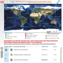
La responsabilité de l'auteur ne peut être engagée quant à leurs contenu ou éventuelle utilisation. Présentation du Service de Cartographie Rapide (.pdf format) Rapid Mapping Activity products are realised to the best of our ability, within a very short time frame, optimising the material available. Faire_parler_vos_donnees.
Accueil - AITF. Normad1 - Progiciels de traitement des adresses postales : RNVP, déduplication, etc. PTV Loxane: www.ptvloxane.com. Skyline Software Systems: SkylineGlobe 3D earth software solutions. INDIGO-i 3D Modeling Software for Tactical Planning, Analysis and Operational Intelligence. Services cartographiques Cloud. Socrata. OS OpenSpace - quality mapping from Ordnance Survey. The OS OpenSpace® application programming interface (API) enables you to embed and use our maps in business and non-business website or mobile applications.
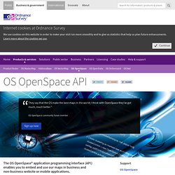
Why choose OS OpenSpace API Increase visitor engagement with your website or app.Enhance your brand by association with ours.Offer richly-detailed maps data of Great Britain, continuously updated .Place name and postcode search tools included.Design your map window using our Web-Map Builder code generation wizard.Includes comprehensive support resources and documentation for Web developers.Free access.Subject to fair-use limits, it's free and you may display ads on the page. Compare the level of detail of OS OpenSpace in rural areas;