
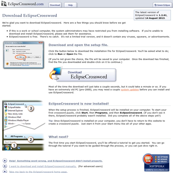
http://www.eclipsecrossword.com/download.aspx
Related: Exerciseurs • Recursos PedagógicosE-Adventure, créez votre jeu d’aventure E-Adventure, créez votre jeu d'aventure E-Adventure est un projet open source qui est écrit en Java. Grâce à celui, tout le monde peut créer un jeu pédagogique d’aventure « point & click ». E-Adventure est un éditeur graphique pour la création et la mise en place de jeux d'aventure, mais qui est spécialement conçu à des fins éducatives. Dans ce logiciel, Les auteurs peuvent utiliser l'éditeur graphique pour créer des jeux ou accéder directement à la source lisible par des documents qui décrivent les aventures en utilisant la syntaxe XML. Tout personne peut écrire le plan éducatif et jeu d'aventure avec <e-Aventure>.Il est facile à utiliser l'éditeur de jeu ne nécessite aucune programmation. 12 vidéos pour l'apprentissage et comprendre le fonctionnement du logiciel.
Physique-chimie - Physique-Chimie - Éduscol Un site : LHC FranceDécouvrez la contribution du CNRS et du CEA au LHC, un instrument international de physique des particules situé au Cern.(Lire la suite >>)Un site : La radioactivitéCe site d’information explique le phénomène physique de la radioactivité, raconte l’histoire de sa découverte et expose ses applications.(Lire la suite >>)La photothèque et la vidéothèque en ligne du CNRS font peau neuveVéritables vitrines, la photothèque et la vidéothèque en ligne du CNRS témoignent, en images, des recherches scientifiques menées sur le terrain et dans les laboratoires du CNRS, aussi bien en France qu’à l’étranger.(Lire la suite >>)Détours scientifiques : le catalogue de l'offre pédagogique du CEARetrouvez toute l'offre pédagogique dans le catalogue du Commissariat à l’énergie atomique et aux énergies alternatives (CEA).
kahoot! un site funky pour créer des quiz interactifs! Dans un de mes derniers billets, je vous présentais l’application eClicker pour créer des quiz pour l’iPad. Dernièrement, j’ai testé IRL des quiz interactifs avec le site kahoot! et les élèves ont été emballés :-) Kahoot! Les sciences s’invitent... Demandez votre conférence...- Délégation Académique à l’Action Culturelle Présentation du dispositif "Les sciences s’invitent... " est un dispositif pour favoriser la diffusion de la culture scientifique et technique au sein des établissements. Il s’agit principalement de fédérer et d’organiser la rencontre des acteurs.trices des sciences et technologies avec les élèves dans un cadre de conférences et d’échanges. Les sciences humaines font pleinement partie de ce dispositif. Le contexte actuel encourage à la consolidation de la culture scientifique et technique dans les établissements.
Création de cours et exerciseurs Logiciels libres ▶ Education ▶ 37 logiciels libres Indispensables Des logiciels qu'il ne faut pas rater. La merveilleuse histoire du mètre, premier étalon universel REPÈRES Jusqu’au XVIIIe siècle il n’existait aucun système de mesure unifié. Malgré les tentatives de Charlemagne et de nombreux rois après lui, visant à réduire le nombre de mesures existantes, la France comptait parmi les pays les plus inventifs et les plus chaotiques dans ce domaine. Plusieurs tentatives d’unification avaient été faites ; on avait par exemple en 1766 adressé aux Parlements des provinces, pour en faire la distribution et en imposer l’usage dans les généralités, 80 exemplaires de l’aune, de la toise, de la livre poids-de-marc de Paris.
Une plateforme pour créer vos activités pédagogiques Nous avons présenté récemment quelques exerciseurs permettant de créer des quiz et autres activités en ligne, avec leurs tutoriels. Voici une plateforme qui vous permettra elle aussi de créer vos propres activités, beaucoup plus facilement qu'avec la majorité des outils disponibles. Educaplay est un produit espagnol, développé par adr formacion. Thèmes - La radioactivité - L'essentiel sur ... la radioactivité Qu’est-ce que la radioactivité ? Dans la nature, la plupart des noyaux d’atomes sont stables, c’est-à-dire qu’ils restent indéfiniment identiques à eux-mêmes. Les autres sont instables car ils possèdent trop de protons ou de neutrons ou trop des deux. Pour revenir vers un état stable, ils sont obligés de se transformer. Ils expulsent alors de l’énergie – provenant de la modification du noyau – sous forme de rayonnements : c’est le phénomène de radioactivité.
Comment télécharger une vidéo sur YouTube et Facebook sans logiciel ? De nombreux logiciels nous proposent de télécharger les vidéos que nous souhaiter conserver hors ligne. Le problème avec ces logiciels, c’est qu’étant bien performants, ils ne proposent que des versions d’essai allant de 5 à 30 jours maximum. Alors, comment faire pour télécharger des vidéos à partir de YouTube ou même Facebook quand on n’a pas les moyens de se procurer une licence payante ? Comment faire sur YouTube par exemple?