
Agenzia per l'Italia Digitale. ArcGIS Open Data. ASTER Global Digital Elevation Map. ASTER Global Digital Elevation Map Announcement The Ministry of Economy, Trade, and Industry (METI) of Japan and the United States National Aeronautics and Space Administration (NASA) jointly announced the release of the Advanced Spaceborne Thermal Emission and Reflection Radiometer (ASTER) Global Digital Elevation Model Version 2 (GDEM V2) on October 17, 2011.
The first version of the ASTER GDEM, released in June 2009, was generated using stereo-pair images collected by the ASTER instrument onboard Terra. ASTER GDEM coverage spans from 83 degrees north latitude to 83 degrees south, encompassing 99 percent of Earth's landmass. The improved GDEM V2 adds 260,000 additional stereo-pairs, improving coverage and reducing the occurrence of artifacts. CAIT Climate Data Explorer. Câmara Municipal de Lisboa - Spatial Open Data. Centre mondial de données sur l’ozone et le rayonnement ultraviolet. CGIAR-CSI Global Aridity and Global PET Climate Database. The Global Potential Evapo-Transpiration (Global-PET) and Global Aridity Index (Global-Aridity) datasets provide high-resolution global raster climate data related to evapo-transpiration processes and rainfall deficit for potential vegetative growth.
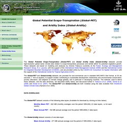
These datasets are based on modeling and analyses by Antonio Trabucco (currently at the Forest, Ecology and Management Research Group, K.U. Leuven), with the support of the International Water Management Institute (IWMI) and the International Centre for Integrated Mountain Development (ICIMOD), and are provided online by the CGIAR-CSI Consortium for Spatial Information with the support of the International Center for Tropical Agriculture (CIAT). The Global-PET dataset consists of the following data layers (Available for download by clicking on links below): CGIAR-CSI SRTM 90m DEM Digital Elevation Database. CKAN. Data.gov. Data.gov.sk. Eu.us.opendata R library.
European Data Portal. European Environment Agency - Data and maps. Eurostat. Free GIS Shapefiles, Software, Resources and Geography Maps. General Bathymetric Chart of the Oceans. GeoNetwork. GIS Climate Change Scenarios. Global 25m Resolution PALSAR-2/PALSAR Mosaic and Forest/non-forest Map. 1.
Updates 2. Overview. Global Aerosol Climatology Project. National Aeronautics and Space Administration Goddard Institute for Space Studies Go to Main Content (Accesskey 2)Go to Site Menu (Accesskey 3)
Global Multi-Resolution Topography Data Synthesis. Google Cloud Storage Public Datasets. Google Cloud Storage provides a variety of public datasets that can be accessed by the community and integrated into their applications.
Google pays for the hosting of these datasets, providing public access to the data via the Google Cloud Platform Console, gsutil, or with the Cloud Storage API. Available public datasets on Google Cloud Storage Landsat: A satellite image dataset from the United States Geological Survey (USGS) and NASA that includes millions of multispectral images of the Earth's land surface, at resolutions of between 15 and 60 meters per pixel, from 1982 through the present.Sentinel-2: A satellite image dataset from the European Space Agency (ESA) that includes multispectral images of the Earth's land surface, with a resolution of 10–60 meters per pixel, from 2015 through the present.
How to use public datasets on Google Cloud Storage. Homeland Infrastructure Foundation-Level Data (HIFLD) Humanitarian Data Exchange. JRC Water Portal. Koordinates. MELODA – Portal for data publishers and profesional reusers of data. Natural Earth. NGA Arctic Open Data. NOAA - ETOPO1 Global Relief. ETOPO1 is a 1 arc-minute global relief model of Earth's surface that integrates land topography and ocean bathymetry.
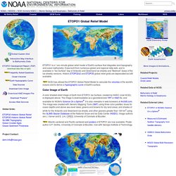
It was built from numerous global and regional data sets, and is available in "Ice Surface" (top of Antarctic and Greenland ice sheets) and "Bedrock" (base of the ice sheets) versions. Historic ETOPO2v2 and ETOPO5 global relief grids are deprecated but still available. NCEI has utilized the ETOPO1 Global Relief Model to calculate the volumes of the world's oceans and to derive a hypsographic curve of Earth's surface.
Color Image of Earth A color shaded-relief image of Earth from ETOPO1 Ice Surface, created by NGDC (now NCEI), is displayed above. NOAA - GSHHG. As of version 2.2.2, GSHHG is released under the GNU Lesser General Public license.
The GSHHG is a high-resolution geography data set, amalgamated from two databases in the public domain: World Vector Shorelines (WVS) and CIA World Data Bank II (WDBII). The former is the basis for shorelines while the latter is the basis for lakes, although there are instances where differences in coastline representations necessitated adding WDBII islands to GSHHG. The WDBII source also provides all political borders and rivers. Open Data - Ministère de l'Éducation nationale, de l'Enseignement supérieur et de la Recherche. Open Data Inception. Open Data Institute. OpenNASA. OpenStreetMap Data Extracts. Plate-forme Open Data des TP suisses. Plateforme ouverte des données publiques françaises. Portail des données ouvertes de l’administration publique suisse. Randolph Glacier Inventory. Dataset Description The Randolph Glacier Inventory (RGI 5.0) is a global inventory of glacier outlines.
It is supplemental to the Global Land Ice Measurements from Space initiative (GLIMS). Production of the RGI was motivated by the Fifth Assessment Report of the Intergovernmental Panel on Climate Change (IPCC AR5). Future updates will be made to the RGI and the GLIMS Glacier Database in parallel during a transition period. The World Bank - Data. U.S. Bureau of Economic Analysis (BEA)
UNEP Environmental Data Explorer. USGS HydroSHEDS. Widukind. WorldClim.