Satellite Geodesy at the Scripps Institution of Oceanography, University of California San Diego. EMODnet Bathymetry Portal. Wiki:dem_sources - WorldGrids. Global Multi-resolution Terrain Elevation Data 2010 (GMTED2010) The U.S.

Geological Survey (USGS) and the National Geospatial-Intelligence Agency (NGA) have collaborated on the development of a notably enhanced global elevation model named the Global Multi-resolution Terrain Elevation Data 2010 (GMTED2010) that replaces GTOPO30 as the elevation dataset of choice for global and continental scale applications. Since the time GTOPO30 was completed, the availability of higher-quality elevation data over large geographic areas has improved markedly. New data sources include global Digital Terrain Elevation Data (DTED®) from the Shuttle Radar Topography Mission (SRTM), Canadian elevation data, Spot 5 Reference3D data, and data from the Ice, Cloud, and land Elevation Satellite (ICESat).
GMTED2010 provides a new level of detail in global topographic data. GMTED2010 Viewer. Ordering ASTER GDEM Data. Index of / General Bathymetric Chart of the Oceans (GEBCO) Bathymetry Data Viewer - NOAA. ●Contact Us Navigating the map Click and drag or use arrow keys to pan Mouse scroll forward or use + key to zoom in Mouse scroll backward or use - key to zoom out Identifying features You have several options to identify features within visible layers: Single-click on the map Or, choose another tool from the "Identify" menu: Click on to draw a rectangle Click on to draw a polygon Click on to enter coordinates for a bounding box A popup will appear with a list of the selected features.
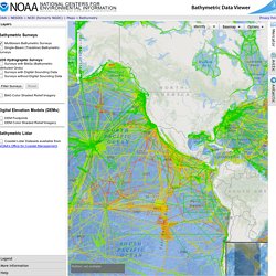
Design a grid for Bathymetry Maps - GEODAS (NOAA) Welcome to IHO. Hidrologia Computacional & MDT (PDF)