
Free worldwide routable Garmin maps from OpenStreetMap. Scarica le mappe « Openmtbmap.org – Mappe per Mountain Bike e Escursionismo basate sulle OSM. Why are there New maps and Old Maps CCBYSA?
Well, Opentstreetmap changed their license in July 2012. As there needed to be quite a lot of contributions to be deleted, the state of the maps was for some time quite troublesome. In most countries and areas the maps under the odbl license are as of 2013 far superior. The old maps are also not having all the newest features (e.g. housenumber address search). The New Maps Can be found Here Maps for Mac OSx can be found Here The Old Maps (Data from 6. Programmi per visualizzare le Openmtbmap Per tutte le persone della terra le mappe Openmtbmap.org vengono visualizzate su Qlandkarte_GT - QLandkarte_GT è compatibile con tutti i più grandi sistemi operativi OS (Linux, MacOSx e sì anche su Windows). Mappe per Mountain Bike e Escursionismo basate sulle OSM. Karten Download « VeloMap.org – Fahrrad, Rennrad -Karten basierend auf Openstreetmap. Warum gibt es "Neue Karten (odbl)" und "Alte Karten CCBYSA"?
Openstreetmap.org hat gerade die Lizenz von CCBYSA 2.0 im Juli 2012 auf odbl geändert. Daher mussten einige Daten gelöscht werden, von Contributors die der neuen Lizenz nicht zustimmen konnten, oder wollten. Derzeit – Februar 2012 sind nun in fast allen Gegenden die neuen Karten erheblich besser wie die alten noch unter CCBYSA 2.0 stehenden Karten. Die neuen aktuellen Karten können Hier heruntergeladen werden.
Ricerca per località di mappe utilizzabili liberamente con GPS Garmin® Come generare Custom Maps per ricevitori Garmin. Una delle possibilità più interessanti per i possessori di gps Garmin della serie Oregon, Colorado, Dakota, Gpsmap62 e Edge 800 è quella di utilizzare sul proprio ricevitore mappe raster attraverso la tecnologia Custom Maps . Parlando di mappe raster ci si riferisce a immagini, in sostanza foto satellitari o carte topografiche scannerizzate. Vista però la nascita più o meno in contemporanea del servizio a pagamento BirdsEye , Garmin ha scelto di sostenere quest'ultimo imponendo dei limiti alla tecnologia CustomMaps: l'utilizzo di immagini in formato .jpg con una dimensione inferiore a 1024X1024 pixel per ogni immagine (un piccolo ritaglio di mappa) e fino ad un massimo di 100 immagini per volta Custom Maps da map server Mobile Atlas Creator è un software open source, multi piattaforma e che non necessita di essere installato (scritto in Java).
Consente di prelevare dati da un lungo elenco di map server ed esportarli in diversi formati: fra questi anche Garmin Custom Maps (.kmz) . Note. Www.okmap.org/download/okmap_en.pdf. Video. Shop on-line Cartografia 4Land. Comment modifier les cartes MapSource? « LABLOGATOIRE. Exemple de carte Map Source modifiée Cet article ne parle pas d’une grande innovation technologique mais peut vous aider si vous voulez modifier des cartes dans le logiciel Map Source pour les utiliser dans votre GPS Garmin.
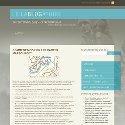
Dans mon cas, je fais ça pour rajouter des sentiers et des lignes cadastrales sur des cartes topographiques. Les logiciels que j’utilise pour ce faire sont GPSMapEdit et cGPSmapper, que vous pouvez télécharger respectivement ici et ici. Installez les logiciels.L’étape suivante est de déterminer quelle carte vous voulez modifier.Dans Map Source, prenez en note les coordonnées géographiques approximatives de l’endroit à modifier.Trouvez le répertoire “Garmin” sur votre ordinateur. Dans mon cas, il est directement sur le “c:/”. Voilà, vous avez vos cartes modifiées dans votre GPS! EveryTrail - Travel Community, iPhone Guides for Sightseeing, Hiking, Walking Tours and more. Map Bike Rides with Elevation Profiles, Analyze Cycling Performance, Train Better. Ride With GPS.
Untitled. GPS - Ciclismo - Mountainbike - percorso Endine-Fonteno-MonteBoario-Colli di S.Fermo-Monasterolo - 24060 Endine Gaiano, Bergamo, Lombardia. Created Monday, February 7, 2011 2:51:26 PM Fly tour as Google Earth Animation New! Altitude Profile Altitude range 3,237 feet (Altitude from 1,088 feet to 4,325 feet) Total climb 3,497 feet Total descent 3,484 feet GPSies-Index 9.97 New!
Fiets-Index 4.11 Description Buon giretto in MTB. Primo tratto su asfalto fino a Solto Collina, poi si gira verso Fonteno e si inbocca quasi subito una mulattiera tutta pedalabile anche se dura (in altenrativa è possibile seguire la strada che sale verso il paese di Fonteno, che sale dolcemente, e che si ricongiounge poi con la traccia). Passato il piccolo centro del paese inizia la salita vera, intergalmente su ciottolato e sterrato ma con ottimo fondo.
Una volta ritrovata la strada si passano un paio di cascinali rimessi a nuovo e si prosegue verso il monumento dei caduti della II Guerra presso i Colli di S.Fermo. Finale su un ghiaione fino alla cappella cotruita in memoria della frana che si abbattè sui paesi di S.Felice e Monasterolo. Starting Coordinates. Giscover - GPS tours, tracks and waypoints for adventure touring - Sotto il cielo: Cartografia gratuita. GPS Mapping Software for Windows.