
Des cartes sur vos sites : quelques bonnes pratiques | Édition Nº34 Le numérique n’a pas remis en question la puissance des cartes comme support de représentation de l’information géographique ou géolocalisée. Au contraire, avec l’interactivité, il leur a apporté une dimension supplémentaire qui a encore accru leur intérêt et fait apparaître de nouveaux usages. Sur le Web, les cartes sont maintenant des éléments communs de l’expérience de navigation, rencontrées dans une multitude de contextes. Les cartographes considèrent comme vertus cardinales la lisibilité et la pertinence de l’information portée par une carte, sans négliger son aspect esthétique. Dans cette optique, cet article est une collecte de conseils, issus de retours d’expériences et de ma veille sur les pratiques en cours. Quelles cartes et quels outils ? Prenons les exemples suivants : Autant de cartes et de situations qui diffèrent en termes d’information représentée, de degré d’interactivité et de dynamique du contenu. Personnalisez ! Personnaliser l’apparence de la carte. Sur mobile
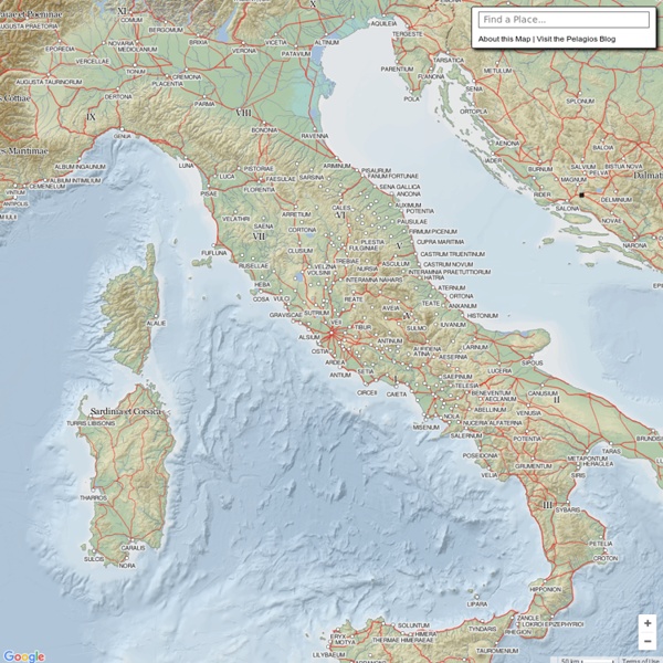
The Romans: From Village to Empire (2nd edition; 2011) | Ancient World Mapping Center A second edition of Mary T. Boatwright, Daniel J. Gargola, Noel Lenski, Richard J. A. The maps below were originally created by the Ancient World Mapping Center. Map 1.1 Archaic Italy [Full-size .pdf version] Map 1.2 Southern Italy and Sicily [Full-size .pdf version] Map 1.3 Northern Italy [Full-size .pdf version] Map 1.4 Rome and Environs [Full-size .pdf version] Map 1.5 Rome in the Early Republic (before 300 B.C.) Map 2.1 Latium and Southern Etruria [Full-size .pdf version] Map 2.2 Latium and Campania [Full-size .pdf version] Map 2.3 Samnium [Full-size .pdf version] Map 2.4 Southern Italy [Full-size .pdf version] Map 3.1 Western Mediterranean in the Mid-Third Century [Full-size .pdf version] Map 3.2 Northern Italy [Full-size .pdf version] Map 3.3 Southern Italy and Sicily [Full-size .pdf version] Map 3.4 Iberian Peninsula [Full-size .pdf version] Map 3.5 Greece, the Aegean, and Western Asia Minor [Full-size .pdf version] Map 5.1 Rome’s Foreign Wars, 113-82 [Full-size .pdf version] Map 5.2 Social War
.:: Sidera Visus ::. | El Rincón de Libros de Ciencia Ficción Aegean Bronze Age Mycenaean society appears to have been divided into two groups of free men: the king's entourage, who conducted administrative duties at the palace; and the people (da-mo, later Greek demos) – craftsmen, farmers and others – who lived at commune level. The people were watched over by royal agents and were obliged to perform duties for and pay taxes to the palace. On a lower rung of the social ladder were found the slaves. The one who were essentially important were the people who traded abroad and the people who fought, as well as the men who led them. The territory of the Mycenaean kingdoms of Pylos and Knossos that we know more about thanks to the relative abundance of records, was divided into two parts: the palace lands and the communal lands. Pictures:
Flickr Many Flickr users have chosen to offer their work under a Creative Commons license, and you can browse or search through content under each type of license. Here are some recently added bits and pieces: Attribution (CC BY 2.0) » 91767649 photos (See more) Attribution-NoDerivs (CC BY-ND 2.0) » 25009436 photos (See more) Attribution-NonCommercial-NoDerivs (CC BY-NC-ND 2.0) » 117052837 photos (See more) Attribution-NonCommercial (CC BY-NC 2.0) » 63465514 photos (See more) Attribution-NonCommercial-ShareAlike (CC BY-NC-SA 2.0) » 131662580 photos (See more) Attribution-ShareAlike (CC BY-SA 2.0) » 49480401 photos (See more) Public Domain Dedication (CC0) » 4786372 photos (See more) Public Domain Mark » 13393877 photos (See more) "Creative Commons is a non-profit that offers an alternative to full copyright." creativecommons.org Briefly... Attribution means: You let others copy, distribute, display, and perform your copyrighted work - and derivative works based upon it - but only if they give you credit.
De Nîmes vers ailleurs | Expériences (en cours) de cartographie culturelle en bibliothèque Pomponius Mela Reconstruction of Pomponius Mela's world map by Konrad Miller (1898). Pomponius Mela's description of Europe (F. Nansen, 1911). Pomponius Mela, who wrote around AD 43, was the earliest Roman geographer. He was born in Tingentera (now Algeciras) and died c. His short work (De situ orbis libri III.) occupies less than one hundred pages of ordinary print. Biography[edit] Little is known of the author except his name and birthplace—the small town of Tingentera or Cingentera in southern Spain, on Algeciras Bay (Mela ii. 6, § 96; but the text is here corrupt). Geographical knowledge[edit] The general views of the De situ orbis mainly agree with those current among Greek writers from Eratosthenes to Strabo; the latter was probably unknown to Mela. The shores of Codanus sinus (southwestern Baltic Sea) in red with its many islands in green. Descriptive method[edit] Editions[edit] References[edit] Jump up ^ Tegg, Thomas (1824). External links[edit] Pomponius Mela's.
¿Qué es una vida interesante? Regularmente invitamos a amigos y personas con miradas diferentes e ideas frescas a que escriban un post con su propia aproximación a una vida interesante. Algunos se quedan con nosotros y luego postean sobre todo tipo de cosas. Queremos dar las gracias especialmente a: Michel Bauwens, impulsor y presidente de la P2P Foundation. El objetivo de «El Correo de las Indias» es abrir conversaciones, generar ideas y desarrollar reflexiones que te sirvan en el empeño de hacer de tu vida una vida interesante. Para los que hacemos «El Correo de las Indias» una vida interesante es una vida que se dota de sentido a través de la pasión por aprender. Si estás aquí es porque compartes con nosotros esa búsqueda, porque quieres construir un modo de vida productivo y confortable, lleno de retos y aprendizajes. Por eso, desde 2002, compartimos en este blog ideas excéntricas, debates enriquecedores, software liberador, partidas hermosas, historias curiosas y momentos especiales.
Ancient Greece on Tripline The Battle of Marathon is one of the most famous battles in history. It was a triumphal victory for the Greeks over the Persians, which boosted Greek confidence and without which Europe may never have enjoyed the classical culture which has so influenced western civilisation. After Marathon the Persians attacked Greece again ten years later in 480 BC, when they won a victory at Thermopylae and then sacked Athens, but were themselves finally defeated by the Greeks at Salamis and Plataea. These were the Persian Wars recorded by Herodotus, the 'Father of History'. The victory at Marathon was marked on the battlefield by a burial tumulus for the 192 Greek hoplites who died, and this is still on the same site today, along with a site museum.
Crumpled city - palomar They are the lightest maps in the world: indestructible, soft and waterproof, they can be crumpled, squashed and crushed into a ball. What’s more, the more battered they are, the better they look. A contemporary reinvention of the most basic travel tool: - they are easy to use, more fun and inspire more freedom than traditional maps; - they have a completely new look, from the street mappings to the colour scheme and include fresh and fun new city icons; - they provide details about a large part of the city, including streets, monuments, museums, art galleries and much more; - Soulsights are unique places specifically chosen to move, touch and inspire the modern traveller. The collection includes the most interesting cities on the globe. Crumple it before use! It just takes 2 seconds to open and close this innovative soft map. The map includes all the most important information about the city as well as a list of Soulsights Weighing only 21 grams, it is super resistant and 100% waterproof
Omnes Viae: Tabula Peutingeriana - Itinerarium Romanum / Planificateur d'itinéraire