
Bora Bora Map and Information, Map of Bora Bora, Facts, Figures and Geography of Bora Bora -Worldatlas.com. Bora Bora, located about 160 miles northwest of Tahiti and approximately 2,600 miles south of Hawaii, was discovered in 1722, and is arguably the most beautiful island on the planet.
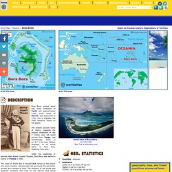
The island's ancient name of Vava'u suggests the original inhabitants of this 7 million year old island arrived from Tonga, and interestingly, there is no "B," in the local Tahitian language, so its actual name is Pora Pora, meaning "first born. " Under the leadership of Admiral Abel Aubert Dupetit Thouars, Bora Bora was named a colony of France in 1842. The onset of World War II brought U.S. troops to the island, and seven massive cannons were set up around the perimeter, as well as a number of forts. The presence of the troops was generally accepted, and lucky for the natives (and troops alike) no combat took place on the island during the war. The U.S. military base officially closed on June 2, 1946, and the abandoned base became an international airport until Tahiti opened their own in 1962.
Map of Asia, Asian Countries, and Asian Landforms and Rivers. Map of Africa, Maps of African Countries, landforms and rivers, and Geography Facts. Print this map >>> LARGER (printable) AFRICA MAP As for Africa, scientists have formerly concluded that it is the birthplace of mankind, as large numbers of human-like fossils (discovered no where else) were found on the continent, some dating back 3.5 million years.
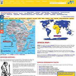
About 1.75 million years ago, early man spread throughout parts of Africa. They became aggressive hunters, lived in caves and used fire and their ability to create stone tools just to survive. The Neanderthals arose some 200,000 years ago and inhabited regions in northern Africa and across parts of southern Europe. There is also clear evidence that they had control of fire, lived in caves, as well as open-air structures of stone and vegetation.
One of the most important developments of primitive man was the creation of stone tools. In 3200 BC the Egyptian culture emerged along the lower reaches of the Nile River; it was among the earliest civilizations and their tools and weapons were made of bronze. Middle East Map, Map of Middle East, Turkey, Iraq, Dubai Map. The so-called modern version of the Middle East sits where Africa, Asia and Europe meet.
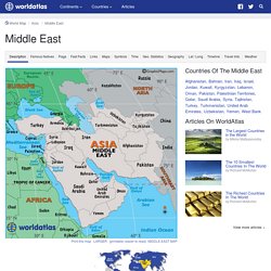
The countries of the modern Middle East are all part of Asia, but for clarity reasons we geographically show them here as a separate landmass. The Greater Middle East Map includes all countries on the map to the left including Afghanistan and Pakistan, and all the other "stans," but it also includes many North African countries like Egypt, Libya and Sudan. See Map. Of note, Armenia and Azerbaijan have long established ties to Asia and the Middle East, but in recent years, they are beginning to align more with Europe based on their modern economic, political and socio trends. That's very much like Georgia, the former Russian republic, now a part of Europe.
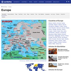
On this map (our map) we attempt to show the modern definition of the Middle East, but in the world of geography, there are often many answers (or personal or political opinions) to what appears to be a simple question - What is the Middle East? Map of Europe, European Maps, Countries, Landforms, Rivers, and Geography Information. Europe History As for Europe, a brief chronological account of its significant events begins during prehistoric times with the emergence of Homo sapiens (early man), roughly 40,000 years ago.
Central America Map - Map of Central America Countries, Landforms, Rivers, and Information Pages. Central America, a part of North America, is a tropical isthmus that connects North America to South America.
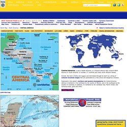
It includes (7) countries and many small offshore islands. Overall, the land is fertile and rugged, and dominated through its heart by a string of volcanic mountain ranges that are punctuated by a few active and dangerous volcanos. Map of South America, South American Countries, Landforms, Rivers, and Geography Facts. South America, the planet's 4th largest continent, includes (12) independent countries and (3) major territories; the Falkland Islands, Galapagos Islands and French Guiana.
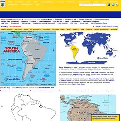
The continent contains the world's highest waterfall, Angel Falls in Venezuela; the largest river (by volume), the Amazon River; the longest mountain range, the Andes, and the driest place on earth, the Atacama Desert in Chile. Map of Canada, Canada Map, Map Canada, Canadian Map. Canada's original inhabitants originated in Asia; as they searched for food, people from that continent crossed the Bering Strait between Alaska and Russia.
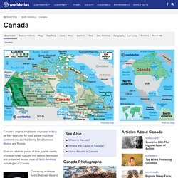
Over an indefinite period of time, a wide variety of unique Indian cultures and nations developed and prospered across most of North America, including all of Canada. Convincing evidence exists that near the end of the 11th century, Leif Ericson, a seafaring Viking from Scandinavia, traversed the frigid waters of the North Atlantic Ocean and established a small settlement named Vinland along the coast of Newfoundland; it was eventually abandoned. Giovanni Caboto, an Italian navigator and explorer, known in English as John Cabot, landed along the northeastern shore of Canada in 1497, and immediately claimed the land for his patron, King Henry VII of England.
The Cabot discovery substantiated England's claim to a significant slice of North America. Caribbean Map, Map of Puerto Rico, Map of Cuba, Map of Jamaica. Caribbean Islands Travel Information. The Caribbean, long referred to as the West Indies, includes more than 7,000 islands; of those, 13 are independent island countries (shown in red) on the map, and some are dependencies or overseas territories of other nations.

In addition, that large number includes islets (very small rocky islands); cay's (small, low islands composed largely of coral or sand) and a few inhabited reefs: See Belize. Australia Map, Atlas of Australia, Australia Cities States Deserts Territories. Oceania, the planet's smallest continent, is without doubt one of the most diverse and fascinating areas on the planet.
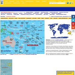
A large percentage of geography experts now consider the long-established continent of Australia to be more accurately defined as Australia/Oceania. Map of Oceania - Pacific Islands, French Polynesia. United States Map. Maps - National Geographic. Google Maps.