
Mariners Met Pack » About MetService. Click on the chapter links below to download the Mariners Met Pack: Basic Weather Forecasting How to Read a Weather Map Isobars and the Wind South Pacific Weather Tropical Cyclones.
Frank Singleton's Weather and Sailing Pages - Franks-Weather - The Weather Window. Updating TLinks have been checked most recently in February 2020 but is always likely to have errors due to website, even official ones, changing with no prior warning.
Information about broken links is always welcome. Introduction to Frank's Weather Site Weather determines where we sail to, when we sail there and if we sail at all. This site is a guide to marine weather forecasts and how to use them. This site applies my long and wide experience in meteorology and sailing to help others to whom weather forecasts, and marine weather forecasts in particular, are mysteries. Over the years, when I have seen a need, I have added other pages that might be of interest - including the vexed issue of climate change. A cruising yachtsman’s Viewpoint Anhinga on passage from Port Joinville, Ile d'Yeu to Les Sables d'Olonne on 4th June, 2017. (Courtesy of Sue Large, S/V Jinn who was overtaking us at the time.) To us, in our Hallberg-Rassy 34, Anhinga, cruising is all about sailing enjoyably and safely. Climatology of Global Ocean Winds - COGOW. Recevoir des Faximilé Météo par blu.
- SeaTTY programme radio amateur que nous utilisons aujourd'hui sous Windows 10.
Très simple à utiliser avec une licence d'un prix abordable ( 39 Euros , prix 2017) Un programme pour recevoir des bulletins météorologiques, ,des des cartes météorologiques transmises dans les modes RTTY, NAVTEX et HF-FAX (WEFAX) sur les ondes longues et les ondes courtes. Il peut décoder les messages GMDSS DSC (HF et VHF). Les logiciels peuvent également enregistrer automatiquement les messages vocaux NOAA Weather Radio SAME (NWR SAME) et les en-têtes numériques. Aucun matériel supplémentaire n'est nécessaire - vous n'avez besoin que d'un récepteur et d'un ordinateur avec une carte son. Mode d' emploi se SeaTTY : Régler la fréquence de réception sur la fréquence de l' émetteur -1,9kHz en USB ou +1,9kHz en LSB; sur l' image ci dessus la fréquence est réglée sur 12788 USB pour une fréquence de 12789,9 kHz (New Orléans USA) En mode HF-FAX, une fenêtre supplémentaire est ouverte.
Comment formuler une requète et ou l'envoyer pour recevoir grib via skyfile? GRIB File Download Instructions. Instructions For Free GRIB Files Provided by Global Marine Networks Instructions for Free GRIB File Downloads from Global Marine Networks Global Marine Networks (GMN) offers 7 day wind forecasts of the world as a free public service via its GRIB Mail Robot.
These forecasts are generated daily for every region of the world. GRIB forecasts are based on the National Weather Service Wave Watch III model yielding highly accurate forecasts every 6 hours for up to 7 days into the future. All GRIB forecasts are delivered via e-mail and optimized specifically for low bandwidth wireless connections. Prevailing Ocean Winds—Wind Rose Browser. As a convenient alternative to pilot charts, this website provides an interactive wind atlas and windrose browser.
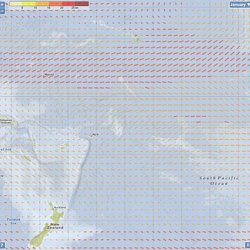
Unlike classical pilot charts, this atlas is based on satellite data (uniformly-sampled, unbiased), insofar similar to Jimmy Cornell`s Ocean Atlas (on paper, pricey...). We visualize world-wide ocean wind data from the SeaWinds scatterometer onboard the QuikSCAT satellite monthly-averaged over ten years. Data taken from Climatology of Global Ocean Winds—COGOW. The arrows show the prevailing winds for the selected month at a 2-by-2 degree longitude/latitude grid.
The direction and length of the arrows correspond to the vectorially averaged monthly wind data over 10 years and over 2-by-2 degree areas (i.e., the longer an arrow, the more predominant the indicated wind direction). Wind data visualization, incl. the windroses in SVG format created (and copyright ©) by Christian Feldbauer in 2010-2016. L’Organisation météorologique mondiale. Offshore weather planning with Chris Tibbs – Yachting World. Sailing weather expert Chris Tibbs is off on a round the world cruise.

He explains the options for receiving weather data at sea and reveals what he will be using When I skippered a yacht in the first Atlantic Rally for Cruisers (ARC) 30 years ago the weather planning information we had after we left Las Palmas was just about zero. Navigation was chiefly via sextant. But communications and navigation has changed immeasurably since then and with it our choices. During the last Azores and Back race (AZAB) we gybed off the direct route to jump 50 miles north, and took the leg by over seven hours on corrected time.
Today we are used to getting a huge amount of information from the internet, but this quickly drops off as we head offshore. However, there are still a lot of choices to be made depending on requirements and budget. ZyGrib: grib file, weather data visualization. Gribs by email Personnal code generatorA code can be generated at any time, using your login and password on zyGrib's forum.
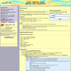
Validity of the code: 2 months. Purpose This service is intended to those who have difficulties to retrieve grib files directly from zyGrib because of limited internet connection. This service is available only to subscribers of the zyGrib's forum. Limitations Limitations were put in place to limit abuses so that the server remains available to the largest number of users: Maximum 16 emails per user and per 24 hours. Usage. Passages and weather windows to new caledonia.
Sailing or motoring to New Caledonia is an enjoyable experience so long as you pick the correct weather window and the vessel is seaworthy.
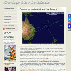
Picking the weather is easier than ever these days with long range weather forecasts and satellite imagery. But there is a knack to doing it. My wife, Frederique and I have made these passages over the past 30 years we have been annually migrating between the Pacific Islands aboard the Moira. 90% of our passages have been relaxing, and pleasant. The methods we use are described in full detail on the cruising guide to Vanuatu and on the cruising guide to New Caledonia along with time-lapse images, month by month, of the weather patterns in the south Pacific. If you want to make "magic" passages get our cruising guides and go over the instructions. 1.