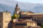
Spain. Alhambra. Alhambra The Alhambra (/ælˈhæmbrə/, Spanish: [aˈlambɾa])[a] the complete form of which was Calat Alhambra,[b] is a palace and fortress complex located in Granada, Andalusia, Spain. It was originally constructed as a small fortress in 889 and then largely ignored until its ruins were renovated and rebuilt in the mid 11th century by the Moorish king Mohammed ben Al-Ahmar of the Kingdom of Granada who built its current palace and walls, and later converted into a royal palace in 1333 by Yusuf I, Sultan of Granada.[1] The Alhambra's Islamic palaces were built for the last Muslim emirs in Spain and its court of the Nasrid dynasty. After the Reconquista by the Reyes Católicos ("Catholic Monarchs") in 1492, some portions were used by Christian rulers.
Layout[edit] Plan of the Palacio Arabe 1889 Art and architectural details[edit] Ceiling in Alhambra Columns and muqarnas appear in several chambers, and the interiors of numerous palaces are decorated with arabesques and calligraphy. History[edit] The Alhambra, The City of Granada, History of the Alhambra Andalucia, Southern Spain. The Alhambra and the backdrop of the magnificent Sierra Nevada mountain range Alhambra Tickets | Alhambra Tour | Online Store The name Alhambra comes from an Arabic root which means "red or crimson castle", perhaps due to the hue of the towers and walls that surround the entire hill of La Sabica which by starlight is silver but by sunlight is transformed into gold.
But there is another more poetic version, evoked by the Moslem analysts who speak of the construction of the Alhambra fortress "by the light of torches", the reflections of which gave the walls their particular coloration. Created originally for military purposes, the Alhambra was an "alcazaba" (fortress), an "alcázar" (palace) and a small "medina" (city), all in one. This triple character helps to explain many distinctive features of the monument. There is no reference to the Alhambra as being a residence of kings until the 13th century, even though the fortress had existed since the 9th century. SKAFTAFELL NATIONAL PARK. The second national park, Skaftafell., established in 1967 (400-500 square kilometres), contains some of the most precious natural pearls of the country.
The rugged landscapes, mountains and glaciers, the flora and the fauna have a magnetic influence on the visitors. In 1984, it was increased in area (1736 square kilometres) including a considerable part of Glacier Vatnajokull. In November 2004 the area of the park was still increased to 4,807 square kilometres. It now comprises the Laki Area as well as about half of Euorpe's largest icecap, Vatnajokull.
There are no roads in the park, but a network of trails offers the opportunity for differently extended hikes. Skaftafell National Park 785 Fagurholsmyri Tel.: 470-8300 Fax.:470-8309 skaftafell@vjp.is Skaftafell Visitor Centre Open hours: On June 7th 2008, the whole glacier and some of its surroundings, two existing Nationa Parks, and some nature reserves, were declared Europe's larges National Park, Vatnajokull. The crystal cave. By Jill Reilly Updated: 17:06 GMT, 23 December 2011 Created by the awesome forces of the Vatnajvkull ice cap in the south of the volcanic island, the deep blue cave was formed by the glacier meeting the coastline.
The centuries old ice that has come from the slopes of 6,921 feet tall Vrffajvkull, Iceland's tallest active volcano, has compressed all air out of the ice adding to the texture and colour of the cave. Nature at its best: Created by the awesome forces of the Vatnajvkull ice cap in the south of the volcanic island, the deep blue cave was formed by the glacier meeting the coastline Changing size: Accessible through a 22-foot entrance on the shoreline, the cave tapers to a tight squeeze at the end no more than four feet high Accessible through a 22-foot entrance on the shoreline, the cave tapers to a tight squeeze at the end no more than four feet high. 'The snow sticks to the ice and has its air bubbles forced out during the movement of the glacier or transit of the ice. Skogafoss (Skogar, South Region, Iceland) Skogafoss Skógar / Southern Ring Road, South Region, Iceland Rating: 4.5 Difficulty: 1 Skogafoss (or more accurately Skógafoss; "SKOH-ga-foss") probably rivals Gullfoss as Iceland's most famous waterfall.
This was a classically-shaped rectangular waterfall that dropped 60m with a width of 25m, and it was this feature that prompted Julie to call this her favorite waterfall in the country. Perhaps a major reason why the falls was so popular was that it was very easy to access. The official path climbed alongside the cliffs surrounding the recess containing the falls to yield precarious top down views of not only the waterfall but also the view towards the Atlantic Ocean as well. During the three days we were staying in Skógar, we were hoping for a little bit of morning sun so we could get that classic photograph of the falls with a rainbow.
Finally, I looked up my Icelandic dictionary to try to learn the meaning of the name of this waterfall, and it said that "skógur" meant "forest". The Giola Lagoon in Greece. Apr 7, 2012 On the beautiful island of Thassos, Greece lies a secluded lagoon near the village of Astris called Giola. This seaside gem is apparently quite a trek, but for those willing to make the journey, they are rewarded with an incredible natural pool to soak in the gorgeous views of the sea.
For one couple’s recount of reaching Giola, check out this blog post. Fairy Pools. In the south of the Isle of Skye, in Scotland, you can find these magnificent Fairy Pools. With a beautiful hiking trail especially in the fall. Turquoise rivers with purple trees on the side make for a stunning view.. Ancient Turkish Cave Towns. Evleri - Cappadocia Cave Hotel.
Gásadalur Village - Faroe Islands | TravelMint.com. Trolltunga. One of Norway’s most spectacular hiking destinations lies in Hardanger. Only nature itself can create something so unnatural as Trolltunga. Trolltunga. Photo: Sveinung Klyve/Fjord Norway Hidden deep within Fjord Norway lies one of the country's most spectacular hiking destinations. A classic unspoilt natural wonder, Trolltunga (The Troll's Tongue) is a narrow rock that struts horizontally out from a cliff 700m above the Ringedalsvatnet lake below. You'll pass waterfalls, luscious green vegetation and steep mountain ridges as you ascend almost 1000m, but the reward is simply breathtaking. The full Trolltunga hike takes up to 10 hours return, and is only recommended for experienced hikers. The best advice for your circumstances will come from the local tourist information office in Odda.
#Trolltunga on Instagram: