
Teach Yourself Quantum GIS. Lex Berman Tutorial. QGIS Labs. QGIS Tutorial Labs Home This is a set of tutorial labs for Quantum GIS, an open source geographic information system.
The labs are based loosely on labs in my course ABT 180. They were developed with the help of the following students: Alex Mandel, Dylan Beaudette, Michele Tobias, Xuyang Zhang, Stacey Ellis, Heidi Schott, Michael Treichler, Melissa Whitaker, Kelly Gravuer, Michael Louie, Joel Bremson, Lauren Poremsky, Siqi Fajn, and Cherry Zamora. Thanks especially to Alex Mandel and Michele Tobias for organizing a seminars to review the labs. The labs are based on QGIS version 1.7.3 (last updated 5/1/2012). I would appreciate hearing comments and suggestions. The labs make use of the following data sets: Field 5 (this is a wheat field located in Central California) Brown's Pond (this is a data set first used in Geographic Information Systems and Cartographic Modeling by C. Introduction to GIS. Quantum GIS: Índice de Tutoriais. Quantum GIS (QGIS) Tutorials.
Relief vizualisation. Sometimes I create hillshades using the QGIS hillshade plugin and then overlay the original DEM over it.
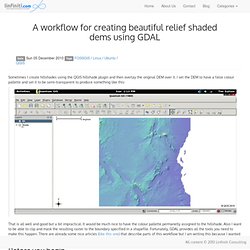
I set the DEM to have a false colour pallette and set it to be semi-transparent to produce something like this: That is all well and good but a bit impractical. It would be much nice to have the colour pallette permanetly assigned to the hillshade. Also I want to be able to clip and mask the resulting raster to the boundary specified in a shapefile. Fortunately, GDAL provides all the tools you need to make this happen. Before you begin Before you begin you should have: a raster containing digital elevation data (DEM) - in my case its called 'alt.tif'a vector layer (typically a shapefile) containing the area of interest for your final product - in my case its called 'tanzania.shp' Create the hillshade image The first thing we need to do is generate a hillshade. So to create our hillshade we do something like this: gdaldem hillshade alt.tif shade.tif -z 5 -s 111120 -az 90 . A final note. 3d visualisation and DEM creation in QGIS with the GRASS plugin - Linfiniti Geo Blog.
Date Thu 09 December 2010 A note from Sam in the Linfiniti team: The last two weeks of FOSS GIS training courses (posted about here) have been impressive.
High-five to the trainers, Tim and Gavin, for their hard work! The Geospatial Desktop » Creating a Standalone GIS Application. In this example we are going to begin to build a standalone GIS application using Python and the QGIS libraries.
We’ll start simple by creating an application to load and display a shapefile. In later posts we’ll enhance the application to provide some map tools and other features. Requirements To build the application we need the following tools installed: QGIS 1.0 PyQt4 Qt 4.3 or higher and the development tools (Designer) Python 2.3 or better Testing the Environment Before getting started we need to test our development environment to make sure everything is in place. From a terminal or command shell on Linux or OS X: export PYTHONPATH=[path to]/share/qgis/python From a cmd shell on Windows: set PYTHONPATH=[path to QGIS]\python If you are using the OsGeo4W install of QGIS, all you need to do is start the OsGeo4w shell.
Start Python from a shell and test the import of the needed components: Now we are ready to get started. Creating the Main Window Now run Qt Designer. We are done in Designer. QGIS GRASS Cookbook. Revision as of 19:47, 12 December 2011 QGIS GRASS Cookbook The GRASS Cookbook (GCB) is a collection of recipes for typical GIS tasks which can be accomplished with GRASS plugin in QGIS.
The recipes can be tried in any order but it is recommended to go through the Getting started section first. Each recipe can be reproduced with publicly available demo dataset. The cookbook presumes that the user has QGIS with GRASS plugin installed (and GRASS plugin enabled in QGIS) and that s/he knows QGIS basics.