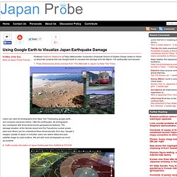
Simulation de Tsunami dans Google Maps. Amazing panoramas of post-earthquake Japan. Gallery. Using Google Earth to Visualize Japan Earthquake Damage. Professor Hidenori Watanave of Tokyo Metropolitan University’s Graduate School of System Design writes to inform us about two projects that use Google Earth to visualize the damage from the March 11th earthquake and tsunami: 1.
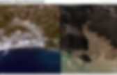
Three-dimensional photo-overlays from “The Aftermath in Japan” by New York Times Users can view 40 photographs from New York Timesusing google earth, and compare sceneries before / after the earthquake. All photographs are overlapped with three-dimensional geographical features. Séisme et tsunami au Japon : Google Earth et Maps mis à jour. Google Earth / GeoEye: Miyako. Google Traduction. Japon : un an après le tsunami vu de Google Earth. Un an après le tsunami qui a ravagé la côte orientale du Japon, une exploration de Google Earth dévoile les profondes cicatrices qui déchirent encore aujourd’hui le paysage côtier nippon.
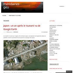
Débris de maisons, arbres déracinés, enchevêtrements de bateaux… sur la côte près de Fukushima Les pictos de Google indiquent toujours l’emplacement des infrastructures (supermarché et hôtel) aujourd’hui complètement détruites. Il ne reste que les murs de l’école de cet ancien village côtier. Sendai_ali_2011077_lrg. Google Traduction. Les satellites viennent en aide aux autorités japonaises. Charte Call n°359 - Charter Call 359. 18 - Carte d'évaluation des dégâts - Vue détaillée / Damage Assessment Map - Detailed Localisation: Centrale nucléaire de Kukushima Daiichi Thème: Situation le 16 mars 2011 Echelle: Image principale: Quickbird-2 acquise le 16 mars 2011 Location: Nuclear Power Plant of Fukushima Daiichi Theme: Situation the 16th of March 2011 Scale: Principal imagery: Quickbird-2 acquired the 16th of March 2011 Cette carte est optimisée pour impression A1 - The map is optimised for A1 printing.
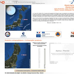
Rapid Mapping Service - 2011. Les produits de cartographie rapide sont réalisés dans un court delai, en optimisant au mieux la donnée disponible.
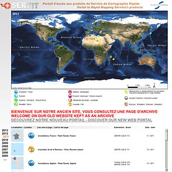
La responsabilité de l'auteur ne peut être engagée quant à leurs contenu ou éventuelle utilisation. Présentation du Service de Cartographie Rapide (.pdf format) Rapid Mapping Activity products are realised to the best of our ability, within a very short time frame, optimising the material available. No liability concerning their content or use is assumed by the producer. Rapid Mapping Service presentation (.pdf format) Satellite Photos - Japan Before and After Tsunami - Interactive Feature. Satellite Photos - Japan Before and After Tsunami - Interactive Feature. Flooding from Tsunami near Sendai, Japan.
NASA’s Terra satellite’s first view of northeastern Japan in the wake of a devastating earthquake and tsunami reveal extensive flooding along the coast.
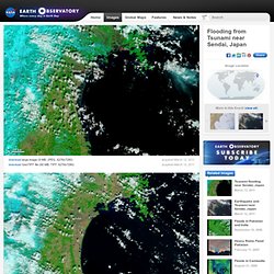
The Moderate Resolution Imaging Spectroradiometer (MODIS) acquired the top image of the Sendai region on March 12, 2011, at 10:30 a.m. The lower image, taken by Terra MODIS on February 26, 2011, is provided as a point of reference. Water is black or dark blue in these images. It is difficult to see the coastline in the March 12 image, but a thin green line outlines the shore. This green line is higher-elevation land that is above water, presumably preventing the flood of water from returning to the sea.
Both images were made with infrared and visible light, a combination that increases the contrast between muddy water and land. MODIS detected a fire burning near the shore north of Sendai. NASA images courtesy the MODIS Rapid Response Team at NASA GSFC. Instrument(s): Google mostra imagens do terramoto no Japão. Como todos temos acompanhado, vindo o Japão chegam imagens de devastação resultado de um forte terremoto de 9 graus de magnitude que atingiu na passada sexta-feira a costa nordeste do Japão.
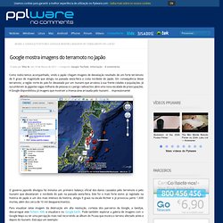
Em consequência desse terramoto, a região norte do país foi devastada por um tsunami que arrastou à sua frente cidades e populações. Já sucumbiram às gigantes vagas milhares de pessoas e o perigo radioactivo abre uma nova escalada de preocupações. A Google disponibilizou já imagens que mostram a imensa área arrasada pelo tsunami… impressionante! O governo japonês divulgou há minutos um primeiro balanço oficial dos danos causados pelo terremoto e pelo tsunami que devastaram o nordeste do país na passada sexta-feira. Este foi o mais forte sismo já registado na história do Japão e um dos mais intensos da história, atingiu 9 graus na escala Richter e já provocou perto 1.600 mortes, além dos cerca de 10 mil desaparecimentos. inShare2. L’impact du tsunami sur le Japon. Photos AVANT/APRES. Fukushima vu de l'espace. Satellite imagery of Japan Earthquake.
Japan - Media Tools. Le séisme japonais sur Google Maps. ABC News - Japan Earthquake: before and after. Development: Andrew KesperSource: Google Aerial photos taken over Japan have revealed the scale of devastation across dozens of suburbs and tens of thousands of homes and businesses.
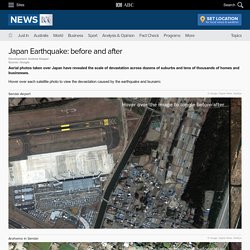
Hover over each satellite photo to view the devastation caused by the earthquake and tsunami. Sendai Airport © Google, Digital Globe, GeoEye Hover over the image to toggle before/after.