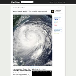

Hurricane Irene - Special Reports. North Carolina - Was in harms way & more On Aug 26th 2011, The Eastern portion of North Carolina is expected to receive the first land fall of the massive category 3 Hurricane, over 200,000 people were under mandatory evacuations yesterday morning through the afternoon.

Hopefully everyone heeded to the words of local public officials as well as the US Government. A state of emergency was issued for all of the neighboring coastal cities, states & towns within the path of Irene's projected land fall. The severity of this vicious storm is real, the build up of the storms force is still unpredictable due to the tropical energy build up, as it swept across the lower tropical regions of North America. Don't plan at the last minute if you in a disaster zone, which has already been designated by numerous reports that's been put out already. Hurricane watch for N.C. coast as Irene approaches. Wide, powerful, and slow-moving, Hurricane Irene is expected to crash ashore in North Carolina on Saturday with winds of 115 mph, and millions of people along the Eastern Seaboard are bracing for what could be a historic storm.

If Irene stays on course straight up the East Coast, it would be the first hurricane to hit New York City directly since 1903 and could force the evacuation of 250,000 residents there. The storm's tropical-force winds extend almost twice as far as normal and are about the same size as Katrina, which devastated New Orleans in 2005. Craig Fugate, head of the Federal Emergency Management Agency, said Irene will cut a wide swath of winds and flooding as a result. "This will not just be a coastal storm," he said. In beach towns up and down the East Coast, summer fun turned to forced retreat. Warnings about Irene's threat were increasingly dire as elected officials tried to motivate residents of flood-prone areas to prepare and, if necessary, get out. 19-app_i.pdf (application/pdf Object) Governor Cuomo Orders State Emergency Response Team to Prepare for Potential Impact of Hurricane Irene. Printer-friendly version Hurricane Irene May Hit New York State on Sunday Albany, NY (August 24, 2011) Governor Andrew M.

Cuomo today ordered the state's Office of Emergency Management to prepare for the potential impact of Hurricane Irene, which may hit New York State this coming Sunday. The Governor has instructed the state's Emergency Operations Center in Albany to track the storm and to work with other state agencies to prepare the state's response. At the Governor's direction, agencies and local governments around the state will meet today to plan coordinated response efforts, such as emergency operations support and field staff deployments to areas that are expected to be hit the hardest.
Hurricane IRENE. Tropical Storm Force Wind Speed Probabilities - 120 Hours Select a Future Forecast Time Below: 0 12 24 36 48 60 72 84 96 108 120 hours Loop Click image to zoom in – Download GIS data: 0.1 degree .shp 0.5 degree .shp Click Here for a Printer Friendly Graphic About this product:

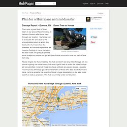
NOAA Graphical Forecast for CONUS Area. NHOP 2011. AfterMath of Irene in Jamaica Queens. This uprooted tree is leaning on the power lines which pretty much saved this house from utter destruction.

There was a great deal of asset damages related to hurricane Irene, and 40+ fatalities across the entire east coast. People were warned by the government ahead of time to get far away from the danger zones, but even then accidental deaths still occurred, this tells us that people truly should heed to the words of our government, city, state & local officials when the word gets out to evacuate your area. Thank god the number of fatalities were very low this time, because Irene's destructive path of land fall reached across all the eastern sea board states except for Florida & was in the path of millions of American's that live or lived on the East Coast. Any, and all informational web locations that can help to inform people is a plus, someone wrote against our free speech usage of current events in hub's, I truly beg to differ.