
Arkaim. Arkaim (Russian: Аркаим) is an archaeological site situated in the Southern Urals steppe, 8.2 kilometres (5.1 mi) north-to-northwest of Amurskiy, and 2.3 km (1.4 mi) south-to-southeast of Alexandronvskiy, two villages in the Chelyabinsk Oblast, Russia, just to the north from the Kazakhstan border.

The site is generally dated to the 17th century BC. Earlier dates, up to the 20th century BC, have been proposed. It was a settlement of the Sintashta-Petrovka culture. Discovery and excavation[edit] Settlement[edit] Although the settlement was burned and abandoned, much detail is preserved. There are four entrances into the settlement through the outer and inner wall with the main entrance to the west. Surrounding Arkaim's walls, were arable fields, 130–140 m by 45 m (430–460 ft by 150 ft), irrigated by a system of canals and ditches. In pseudoarchaeology and national mysticism[edit] Installation art at the Arkaim site.
Swastika City[edit] Observatory[edit] Klyosov findings[edit] See also[edit] Arkaim. The Ancient Land of Arkaim. Architecture is the chronicle of the world, It speaks when songs and legends have no more to say.

—N.V. Ancient Aryan civilization achieved incredible technological pro. The Georgian-Abkhazian relationship became aggravated in 1989, when a Gathering of the Abkhazian people asked the superior authority of the USSR to grant Abkhazia its former status of a Union Republic /the Abkhazian Soviet Socialist Republic was proclaimed in March of 1921.

Ten years later, it became an autonomous member of the Georgian Soviet Socialist Republic; in December of 1990, it was renamed the Abkhazian Autonomous Republic/. In July of 1992, the Abkhazian Supreme Council proclaimed independence of Abkhazia; the decision was not recognized by the central authorities of Georgia. On August 14, 1992, Georgian national guards entered the territory of Abkhazia and occupied its capital, Sukhumi. VEDAS & HUMAN DNA VI - ARKAIM: THE CRADLE OF ARYAN CIVILIZATION.
VEDAS & HUMAN DNA VI - ARKAIM: THE CRADLE OF ARYAN CIVILIZATION. VEDAS & HUMAN DNA VI - ARKAIM: THE CRADLE OF ARYAN CIVILIZATION. VEDAS & HUMAN DNA VI - ARKAIM: THE CRADLE OF ARYAN CIVILIZATION. VEDAS & HUMAN DNA VI - ARKAIM: THE CRADLE OF ARYAN CIVILIZATION. VEDAS & HUMAN DNA VI - ARKAIM: THE CRADLE OF ARYAN CIVILIZATION. Ale's Stones. Ale's Stones at Kåseberga, around ten kilometres southeast of Ystad.

Ale's Stones (or Ales stenar in Swedish) is a megalithic monument in Skåne in southern Sweden. It is a stone ship 67 m long formed by 59 large boulders, weighing up to 1.8 tonnes each. The carbon-14 dating system for organic remains has provided seven results at the site. One indicates that the material is around 5,500 years old whereas the remaining six indicate a date about 1,400 years ago. The latter is considered to be the most likely time for Ales Stenar to have been created. Excavations[edit] In 1989, during the first archaeological excavations performed in order to scientifically investigate and date the monument, archaeologists found a decorated clay pot with burned human bones inside the ship setting. References[edit] External links[edit] Ale's Stones. Ale's Stones. Ale's Stones is a megalithic monument in Scania in southern Sweden Sweden , officially the Kingdom of Sweden , is a Nordic country on the Scandinavian Peninsula in Northern Europe.

Sweden borders with Norway and Finland and is connected to Denmark by a bridge-tunnel across the Öresund.... . The Secret of Ale Stones. Rujm el-Hiri. Rujm el-Hiri (Arabic: رجم الهري, Rujm al-Hīrī; Hebrew: גִּלְגַּל רְפָאִים Gilgal Refā'īm or Rogem Hiri) is an ancient megalithic monument, consisting of concentric circles of stone with a tumulus at center.[1] It is located in the Israeli-occupied portion of the Golan Heights, some 16 kilometers east of the coast of the Sea of Galilee, in the middle of a large plateau covered with hundreds of dolmen.[2][1] Made up of more than 42,000 basalt rocks arranged in concentric circles, it has a mound 15 feet (4.6 m) tall at its center.[2] Some circles are complete, others incomplete.

The outermost wall is 520 feet (160 m) in diameter and 8 feet (2.4 m) high. Rujm el-Hiri. Rujm el-Hiri, Israel - Ancient Archaeoastronomy. Sixteen kilometers east of the Sea of Galilee in the western part of the historic Bashan plain of the Golan Heights (a contested area claimed by both Syria and Israel) are the ruins of a most unusual structure, which scholars believe was built at least in part for archaeoastronomical purposes.
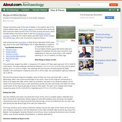
Located at 515 meters above sea level, Rujm el-Hiri consists of a central cairn with a set of concentric rings encircling it. Built during the late Chalcolithic or Early Bronze Age about 5000 years ago, Rujm el-Hiri (also called Rogem Hiri or Gilgal Rephaim) is made of an estimated 40,000 tons of uncut black volcanic basalt field stones piled and wedged into between five and nine concentric rings (depending on how you count them), with heights reaching to 1 to 2.5 meters (3-8 feet) high.
Nine Rings at Rujm el-Hiri. An Error Occurred Setting Your User Cookie. Rujm el Hiri - Recovering the Grinding Stone. Ballochroy. Alexander Thom, known for his work on Stonehenge, maintained that the great length between the stones and the features of distant landscape lent precision to pinpointing the midsummer and winter solstices for ancient observers.

These three stones are considered the most spectacular set of megalithic monuments that cluster around south Argyll. The three mica schist stones were measured at 11 ft 6 in, 9 ft 10 in and 6 ft 7 in (3.5, 3.0 and 2.0 m) in height. It is possible that this last, smallest, stone may have been broken off at the top. Ballochroy. Ballochroy, Kintyre - the standing stone alignment and its astro. How to find : On the A83, 18km south of Tarbert. The site is not visible from the road. A track which you can walk up leads off the main road at NR726527 and climbs the hill to a large barn. The stones are visible in the field beside the barn. Leave your dog in the car. Please leave all gates as you find them. Ballochroy (Stone Row / Alignment) Scran - Prehistoric Cist at Ballochroy, Kintyre.
Callanish Stones. The Callanish Stones (or "Callanish I", Clachan Chalanais or Tursachan Chalanais in Gaelic) are an arrangement of standing stones placed in a cruciform pattern with a central stone circle.
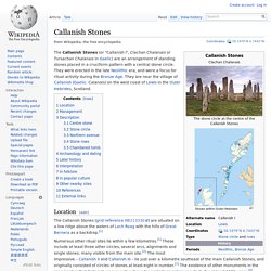
They were erected in the late Neolithic era, and were a focus for ritual activity during the Bronze Age. Callanish Stones. The Callanish Stones - M E g A L i T h i A - Scotland. County: Isle of Lewis NGR NB 213330 (Callanish I) Grouped round the village of Callanish are some wonderful stone circles, single menhirs and of course the great circle and double avenue of stones at the village itself.

The prosaic numbering used to mark the sites is the invention of Professor Thom, whose used them in his 1967 survey. The sites were not necessarily related, and may have been built at different times. The site to see if time is short is of course Callanish I, which has drawn so many visitors that a coffee shop and visitor centre has been placed nearby, with ample car parking but sensitively arranged so it does not interfere greatly with the appreciation of the site itself. Callanish - part of the sequence form 'Standing with Stones' DVD. Callanish Stones. Maeshowe. Maeshowe Maeshowe Entrance Maeshowe (or Maes Howe; Norse: Orkhaugr[1]) is a Neolithic chambered cairn and passage grave situated on Mainland, Orkney, Scotland.
It was probably built in around 2800 BC. It gives its name to the Maeshowe type of chambered cairn, which is limited to Orkney. Maeshowe is a significant example of Neolithic craftsmanship and is, in the words of the archaeologist Stuart Piggott, "a superlative monument that by its originality of execution is lifted out of its class into a unique position. Maeshowe. Maeshowe and the Winter Solstice. Maeshowe, Orkney's finest chambered cairn. "[Maeshowe is] one of the greatest architectural achievements of the prehistoric peoples of Scotland". The parish of Stenness, in Orkney’s West Mainland, is home to some of the county’s best-known monuments. Among these is the prehistoric chambered cairn, Maeshowe. Thought to date from around 2700BC, Maeshowe is one of the monuments that make up the Heart of Neolithic Orkney World Heritage Site. Approximately 500 metres from the south-eastern shore of the Harray loch, Maeshowe is, by far, the largest and most impressive of Orkney’s many chambered cairns.
Appearing as a large grassy mound, it is clearly visible for miles around, including the nearby Standing Stones o' Stenness, the Barnhouse Settlement and the Watchstone. Archaeologist James Farrer first excavated the cairn in 1861, prior to which the mound had a distinctly different shape than it has today. The cairn was taken into state care in 1910, at which time a concrete roof was added to the structure. A Neolithic elite? Viking invaders. Maes Howe (Maeshowe)
Maeshowe: Mound of Wonders pt. 1. Maeshowe: Mound of Wonders pt. 2. Prehistoric Orkney. Prehistoric Orkney refers to a period in the human occupation of the Orkney archipelago of Scotland that was the latter part of these islands' prehistory. The period of prehistory prior to occupation by the genus Homo is part of the geology of Scotland.
Although some written records refer to Orkney during the Roman invasions of Scotland, prehistory in northern Scotland does not end until the commencement of the Early Historic Period around AD 600. There are numerous important prehistoric remains in Orkney, especially from the Neolithic period, four of which form a World Heritage Site. There are diverse reasons for the abundance of the archaeological record. The sandstone bedrock provides easily workable stone materials and the wind-blown sands have helped preserve several sites.[1] The relative lack of industrialisation and low incidence of ploughing also have helped to preserve these ancient monuments. Paleolithic[edit] Mesolithic[edit] Prehistoric Orkney.
Stone Age marvels which inspire and astonish - Scotsman.com Heri. Racing against time to save prehistori. Archaeoastronomy and Stonehenge - Wikipedia, the free encycloped. Stonehenge. Archaeologists believe it was built anywhere from 3000 BC to 2000 BC. Radiocarbon dating in 2008 suggested that the first stones were raised between 2400 and 2200 BC,[2] whilst another theory suggests that bluestones may have been raised at the site as early as 3000 BC.[3][4][5] Stonehenge. Stonehenge. Stonehenge is surely Britain's greatest national icon, symbolizing mystery, power and endurance. Its original purpose is unclear to us, but some have speculated that it was a temple made for the worship of ancient earth deities. It has been called an astronomical observatory for marking significant events on the prehistoric calendar. A Druid priest explains Stonehenge // Current.
Stonehenge Monument. New Stonehenge Discovery. Secrets of Stonehenge. Ancestral Stones. New View on Stonehenge Burials. Stonehenge Builders Village. Stonehenge "Hedge" Found, Shielded Secret Rituals? Evidence for two encircling hedges—possibly thorn bushes—planted some 3,600 years ago was uncovered during a survey of the site by English Heritage , the government agency responsible for maintaining the monument in southern England.
The idea that Stonehedge was a shield against prying eyes isn’t yet firmly rooted, but it's archaeologists' leading theory. For instance the newfound banks are too low and unsubstantial to have had a defensive role. "The best [theory] we can come up with is some sort of hedge bank," said English Heritage archaeologist David Field, whose team discovered the two landscape features in April 2009. Woodhenge. /Woodhenge. New Wood Henge. Remains of the largest timber henge ever found have been discovered at Stanton Drew, near Bristol, a site already famous for its three circles of standing stones. Woodhenge (UK) Henges: Stonehenge, Woodhenge, Avebury & Stanton Drew.
Cahokia. Cahokia Mounds State Historic Site and Cahokia Mounds Museum Soc. Cahokia Mounds State Historic Site - UNESCO World Heritage Centr. Cahokia Mounds State Historic Site Cahokia Mounds, some 13 km north-east of St Louis, Missouri, is the largest pre-Columbian settlement north of Mexico. It was occupied primarily during the Mississippian period (800–1400), when it covered nearly 1,600 ha and included some 120 mounds. It is a striking example of a complex chiefdom society, with many satellite mound centres and numerous outlying hamlets and villages. Cahokia Mounds. Cahokia Archeologists. Unearthing the past - Cahokia: America's Lost Metropolis - BBC. Chaco Culture National Historical Park - Wikipedia, the free enc.
Chaco Culture National Historical Park. Chaco Culture National Historical Park - The Center of a Culture. Chaco Culture. Culture national historical park. CHACO CULTURE NATIONAL HISTORIC PARK / HD. Inside Pueblo Bonito Indian Ruin at Chaco Culture National Histo. Chaco Culture. Mesa Verde National Park. Ancient Pueblo Peoples. Anasazi. Carl Sagan on the Anasazi peoples' calendrical devices. What Happened to the Anasazi. Serpent Mound. Serpent Mound. Cultural Facilities Commission. Serpent Mound - Ohio History Central - A product of the Ohio His. Ancient & Sacred Serpent Mound ~ Possible Birth Place of Humanit. WORLD'S LARGEST EFFIGY SERPENT MOUND AMERICA'S STONEHENGE MYSTER. Sarmizegetusa Regia. Sarmizegetusa Regia. Sarmizegetusa Regia - Romania. Dacian Fortresses - Sarmizegetusa Regia.