
Welcome to APRSISCE/32 - APRSISCE/32 The future of Amateur Radio APRS. Ham Radio Operating Modes. CLOVER -- From Hal Communications Feld-Hell Club - Promoting the Hellschreiber mode - 418 Members Packet Software -- Several to choose from Tucson Amateur Packet Radio -- TAPR, All About Packet, APRS, DSP, Kits & projects North American Digital Systems Directory -- From TAPR Superb Packet Tutorial -- by Larry Kenney, WB9LOZ Packet Radio Training Course -- From The Ventura County ARES AREA 6 Training Group Still Another FB Packet Tutorial -- Buck Rogers K4ABT Amateur Packet Radio Gateways -- World Wide PacketZone -- From Jan, DG1LJP - portal for Packet Radio-Users and offers a lot of links.

Packet Glossary -- The Original By Buck Rogers K4ABT TAPR & Packet Mail List Reflector -- Subscription Info PACTOR NEWS -- Phil Sussman - N8PS PACTOR-II -- SCS Home Page -- The Works - includes a FB FAQ HF Packet BBS's -- Try The Following Frequencies 14,105.5, 14,095.2, 10,149.25, 10,147.25, 7091.5 and 7103.5 North American Digital System Directory -- BBS, DX Packet Clusters, Nodes, Maps RTTY Software.
APRS. APRS Automatic Position Reporting System ~ Amateur Radio Packet APRS GPS AVL. APRS-IS. OpenAPRS - Google Maps APRS. APRS Database Access. APRS: Automatic Packet Reporting System. Google Maps APRS. APRS Information. An Introduction to Automatic Packet/Position Reporting System Reporting System (APRS) Bob Bruninga, WB4APR APRS is a registered trademark of APRS Software and Bob Bruninga, WB4APR. What is APRS? APRS is a real-time tactical digital communicatons protocol for exchanging information between a large number of stations covering a large (local) area.
As a multi-user data network, it is quite different from conventional packet radio. APRS is different from regular packet in four ways. APRS turns packet radio into a real-time tactical communications and display system for emergencies and public service applications (and global communications). Although the recent interfaces to the Internet make APRS a global communications system for live real-time traffic, this is not the primary objective.
APRS Data APRS provides universal connectivity to all stations by avoiding the complexity and limitations of a connected network. ASTARS: an APRS Satellite Tracking and Reporting System. ASTARS SATELLITES: ASTARS stands for APRS Satellite Tracking and Reporting System and refers to digital relay satellites and the global APRS internet linked system of ground stations that tie it all together into full time 24/7 access to these downlinks on the web (See ISS) and (See PCsat).
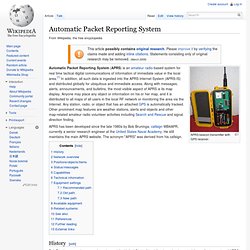
These satellites dating back to 1998 also allow end-user-to-end user real-time digital data exchange typically between mobiles and handhelds. . Email from handhelds is easy using any of the Kenwood or Yaesu APRS walkie-talkies. See the Satellite Simulated Emergency Test page. Tracking: And you don't need any tracking software to know when to operate these birds on a daily basis. See how. Amateur Operating Areas: Although congestion over the USA and Europe make communications challenging via many of the FM voice satellites, the short duration of Packet make it orders of magnitude easier. SATELLITES: The following satellites have supported ASTARS: APRS via International Space Station (ISS) France APRS. APRSdroid. Automatic Packet Reporting System. APRS beacon transmitter with GPS receiver.

Automatic Packet Reporting System (APRS) is an amateur radio-based system for real time tactical digital communications of information of immediate value in the local area.[1] In addition, all such data is ingested into the APRS Internet System (APRS-IS) and distributed globally for ubiquitous and immediate access. Along with messages, alerts, announcements, and bulletins, the most visible aspect of APRS is its map display. Anyone may place any object or information on his or her map, and it is distributed to all maps of all users in the local RF network or monitoring the area via the Internet.
Any station, radio, or object that has an attached GPS is automatically tracked. Other prominent map features are weather stations, alerts and objects and other map-related amateur radio volunteer activities including Search and Rescue and signal direction finding. History[edit] Network overview[edit] Positions/objects/items[edit] Status/messages[edit] APRS: Automatic Position Reporting System.