
Michael Baker Corporation - Geospatial. Home. GeoDecisions. Mapping / GIS Equipment, Software, Service & Training. Geographic Information Systems (GIS) Gain greater confidence and control in data accuracy, administrative costs, call routing and resource allocation.
Intrado GIS products provide better, more informed decision making and a safer, more effective emergency response with intuitive and tightly integrated enhanced 9-1-1 (E9-1-1) and GIS solutions. 9-1-1 Map Audit ®Intrado provides both one-time and on-going 9-1-1 and map data auditing services through its proprietary process and experienced GIS data analyst team.
Intrado 9-1-1 Map Audit services protect and ensure data accuracy that is paramount to timely and precise emergency responses. Caron East. WorldView Solutions Inc. - ArcGIS Server Consulting, Spatial Data Services Locally, Regionally, and Nationwide. Geographic Information Systems. Geospatial technology has been around for decades, but many organizations - large and small - are beginning to discover the potential value of this powerful technology.
Geographic Information Systems (GIS) enable government, businesses and citizens to access and visualize their data spatially making it possible to ask and answer questions that would otherwise not be possible. JMT Technology Group offers consulting and management, data services and analysis, software and applications development, systems integration, infrastructure design and implementation, needs assessments, strategic planning as well as training for enterprise GIS deployments. Geospatial. Pictometry - The Aerial Imagery Company. GIS & Geospatial Technology Services and Products, Enterprise GIS, Mobile GIS, Enterprise Asset Management, Geospatial Solutions. Esri - GIS Mapping Software, Solutions, Services, Map Apps, and Data.
GIS Mapping Applications. City of Roanoke, VA :: Taxmap Parcel Application (Version 1) The City of Roanoke GIS application provides public access to real estate assessment and mapping information.
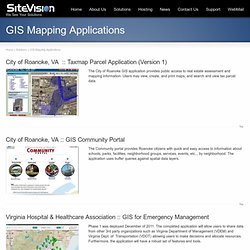
Users may view, create, and print maps, and search and view tax parcel data. City of Roanoke, VA :: GIS Community Portal The Community portal provides Roanoke citizens with quick and easy access to information about schools, parks, facilities, neighborhood groups, services, events, etc.., by neighborhood. The application uses buffer queries against spatial data layers.