
Population par pays - Carte des Pays - Afrique. Using MapServer (1) – 10 Minute Tutorial - Spatial Horizons. May 19th, 2007 UPDATE: This post was originally posted in May 2007 but since has been updated to cover the more recent release of Mapserver version 5.0.0. Most of our recent posts have focused on topics relating more to the components of a mapping application then on the maps and data. This post begins the first of several posts discussing free and open source mapping software applications. After introducing each software, we will explore various ways to create applications around them.
Introduction to MapServer One of the most popular open source GIS applications is MapServer. “MapServer is an Open Source development environment for building spatially-enabled internet applications. Create Your Own Web Mapping Site in 10 Minutes We just need to setup MapServer to run on a local machine for now and the best way to do that is to use MapServer for Windows (MS4W). Congratulations! Continue to part 2. Bienvenue sur le portail de l'eau - Eaufrance. City and Country Maps - Driving Directions - Satellite Views - Routes. IGN : cartes numériques. Google Maps and ASP.NET.
What makes the service even better is the availability of the Google Maps API (Application Programming Interface) as a free Beta service. The API allows developers to embed Google Maps in their custom applications. It also allows them to overlay information on the map and customize the map to their needs. As I write this article there are quite a few sites that utilize Google Maps, and more and more of them are appearing by the day.
The API by itself is pretty straightforward and easy to use; however, it requires the developer to have a good command of JavaScript because it extensively relies on client-side Java scripting. In this article we will be looking at building a custom ASP.NET server control that would allow a .NET developer to harness the power of Google Maps in the code-behind model. Before we get into the details of the ASP.NET control, let's look at the basics of the Google Maps API. Google represents an instance of the map as a "GMap" object. Includes only Zooming controls. Get geographical location (geolocation) by IP address using jQuery.
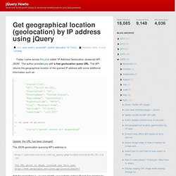
Today I came across this post called “IP Address Geolocation Javascript API : JSON”.

The author provides you with a free geolocation query URL. The API returns the geographical location of the queried IP address with some additional information such as: Update: the URL has been changed! The JSON geolocation querying API’s address is: The URL above is dead, instead use this one: And the great thing is, you can identify your website visitor’s IP and Geo location by simply querying the API without any parameters like this: Knowing your users’ IP and/or location, you might add a behavior to your website that is specific to some location. Anyway, here is a sample jQuery code to query the API: // Build the URL to queryvar url = " // Utilize the JSONP API$.getJSON(url, function(data){ if(data['status'] == 'ok'){ // Do something with the data $('#profile #ip') .append(data['IP']); $('#profile #country') .append(data['CountryName']); }});
IGN, carte de randonnée, carte routière, guide de voyage, guide touristique, topo guide ffrp. Habitants.fr - Le nom des habitants des communes de France. EarthTools - Find places, latitude/longitude, sunrise/sunset, elevation, local time and time zones. Site SisFrance - BRGM - Évaluation informatique gratuite proposées - test informatique gratuit - QCM - Quiz - Exercice evaluit. Welcome - GeoServer. MairesGenWeb. Severe weather warnings for Europe - Mainpage. Using MapServer (1) – 10 Minute Tutorial - Spatial Horizons. Cartes géographiques gratuites, cartes muettes gratuites, cartes vierges gratuites, fonds de cartes gratuits. Le portail des territoires et des citoyens.