
Des cartes technologiques pour la Somalie. Après avoir piloté des projets de cartographie de crise innovante et interactive au Kenya, en Libye, au Japon, en Syrie… Patrick Meier, le chercheur-activiste et directeur de la branche cartographie de crise de la start-up kényane Ushahidi, met son expertise au service de la crise humanitaire qui sévit en Somalie.
Deux projets de cartographie de la crise en cours sont mis en œuvre en partenariat avec l’ONU ou encore avec Al-Jazeera. La complexité de la crise somalienne rend très délicat les actions des humanitaires sur le terrain. L’innovation technologique déployée dans ces projets ne remplace pas le travail mené par des humanitaires expérimentés. Toutefois, ces cartes innovantes et interactives pourraient bien constituer des outils d’un nouveau genre et fort utiles pour les ONG. Les travaux de Patrick Meier et plus largement d’Ushahidi continuent à sans cesse innover, expérimenter et dépasser les barrières qui rendent complexes certains projets. Microtasking Advocacy and Humanitarian Response in Somalia. I’ve been working on bridging the gap between the technology innovation sector and the humanitarian & human rights communities for years now.
One area that holds great promise is the use of microtasking for advocacy and humanitarian response. So I’d like to share two projects I’m spearheading with the support of several key colleagues. I hope these pilot projects will further demonstrate the value of mainstreaming microtasking. Both initiatives are focused on Somalia. The first pilot project plans to leverage Souktel‘s large SMS subscriber base in Somalia to render local Somali voices and opinions more visibile in the mainstream media. I had catalyzed a partnership with Crowdflower during the PakReport deploy-ment last year and wanted to repeat this successful collaboration for Somalia. Our international media partner will help promote this initiative and invite comments in response to the content shared via SMS. Connecting people, tools and resources to support crisis response.
Detecting Emerging Conflicts with Web Mining and Crisis Mapping. My colleague Christopher Ahlberg, CEO of Recorded Future, recently got in touch to share some exciting news.
We had discussed our shared interests a while back at Harvard University. It was clear then that his ideas and existing technologies were very closely aligned to those we were pursuing with Ushahidi’s Swift River platform. I’m thrilled that he has been able to accomplish a lot since we last spoke. His exciting update is captured in this excellent co-authored study entitled “Detecting Emergent Conflicts Through Web Mining and Visualization” which is available here as a PDF.
The study combines almost all of my core interests: crisis mapping, conflict early warning, conflict analysis, digital activism, pattern recognition, natural language processing, machine learning, data visualization, etc. Natural Language Processing (NLP) and event-data extraction applied to crisis monitoring and analysis is of course nothing new.
The RecordedFuture system works as follows. 1. 2. 3. 4. 5. iRevolution. What is Crisis Mapping? An Update on the Field and Looking Ahead. I last updated my piece on A Brief History of Crisis Mapping some two years ago, well before the first International Conference on Crisis Mapping was held (ICCM 2009).
So a brief update on the past 24 months may be in order, especially for a field that continues to grow so rapidly. When I Googled the term “crisis mapping” in September 2009, I got 8,680 hits. Today, one gets over 200,000. If you’re curious about the origins of the field and what happened before 2009, my original blog post still serves as a useful intro. Fourth-Generation Early Warning Systems (Updated) This blog post follows the discussion on first-, second- and third-generation early warning systems from the previous post below.
The purpose of this entry is to make more clear the distinctions between third-generation (3G) and fourth-generation (4G) early warning systems. Note that the distinction between 3G and 4G systems does not imply that one is necessarily better or more effective than the other. Each generation of early warning systems has its own comparative advantage and a role to play in an ecosystem approach to conflict early warning and rapid response. 4G initiatives are a relatively new evolution in the field of conflict early warning and rapid response.
Like 3G systems, they are also based in conflict areas. Furthermore, 3G systems have a highly structured reporting and coding protocol (often based on the FAST protocol) and usually employ a sophisticated, proprietary software program. Invisible Children - Home. Resolve - Home. Invisible Children + Resolve. Syria Tracker. The Syrian War Crowdsourcing Experiment. Think of it as a DIY intelligence agency: An ambitious collaborative project is inviting volunteers to help crowdsource human rights intelligence from the Syrian rebellion.
The joint project, organized by the Standby Task Force and Amnesty International USA's (AIUSA) Science for Human Rights Program, is distributing up-to-date satellite imagery to volunteers who will search for signs of troop movements, demonstrations, and military actions. Image analysis for the project began in early September. Syria: Crowdsourcing Satellite Imagery Analysis to Identify Mass Human Rights Violations. Update: See this blog post for the latest.
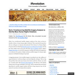
Also, our project was just featured on the UK Guardian Blog! What if we crowdsourced satellite imagery analysis of key cities in Syria to identify evidence of mass human rights violations? This is precisely the question that my colleagues at Amnesty International USA’s Science for Human Rights Program asked me following this pilot project I coordinated for Somalia.
AI-USA has done similar work in the past with their Eyes on Darfur project, which I blogged about here in 2008. Detecting Emerging Conflicts with Web Mining and Crisis Mapping.