
Oregon Parks and Recreation Department: State Parks Oregon Coast Trail Maps. Guided Fishing on the Rogue and Umpqua Rivers' for Salmon and Steelhead in Southwest Oregon: $ PRICES. Prices: Full Day: $225 per personHalf Day: $175 per person1 Person: $300 Fly Fishing Trips Available!
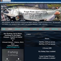
Large Groups Welcome! Gift Certificates Available! A $25 per Person, per Day, non-refundable deposit is required to reserve your date(s).If you pay the FULL AMOUNT (after your deposit) of your trip on a credit card, there is a 4% processing fee. What Should You Bring??? ROGUE RIVER FISHING TRIPS. Rogue River Fishing Guides. Southwestern Oregon Southwestern Oregon U-Pick farms: Find a pick your own farm near you in Southwestern Oregon for fruit, vegetables, pumpkins, organic foods,local produce and more! Looking for a local, pick-your-own farm in Southwestern Oregon?
Scroll down this page and you will see the U-Pick farms in Southwestern Oregon, sorted by county. Those that offer organic or sustainably grown produce are identified by the words "organic" and/or "sustainable" in Green, next to their name (see "What does Organic mean? "). The U-pick crops they offer follow the name of the farm. To search the page for a specific crop, use Ctrl-F (or on an ipad or Mac, use their "search on this page" function) If they have a website, the name will be in blue and underlined; click on it and it will open their website. If you find anything outdated or inaccurate, see the customer and farmer menus (as appropriate) at the top menu bar to submit updates and corrections and help me keep each current! New! Remember to always check with the farm's own website or Facebook page before you go - or call or email them if they don't have a website or Facebook page.
Coos County.
William L. Sullivan, Oregon hiking book author, reveals location of Broken Top's scenic lake. One of the most scenic places in the Oregon Cascades, the lake in the crater of Broken Top in the Three Sisters Wilderness, has finally landed in one of William L.
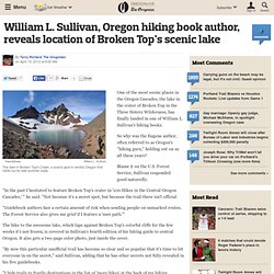
Sullivan's hiking books. So why was the Eugene author, often referred to as Oregon's "hiking guru," holding out on us all these years? Blame it on the U.S. Forest Service, Sullivan responded good-naturedly. "In the past I hesitated to feature Broken Top's crater in '100 Hikes in the Central Oregon Cascades,' " he said. "Guidebook authors face a certain amount of risk when sending people on unmarked routes. The hike to the awesome lake, which laps against Broken Top's colorful cliffs for the few weeks it's not frozen, is covered in Sullivan's fourth edition of his hiking guide to central Oregon. "By now this particular unofficial trail has become so clear and so popular that it's time to let everyone in on the secret," said Sullivan, adding that he has other secrets not fully revealed in his five guidebooks. -- Terry Richard.
Deschutes National Forest - stelprdb5299503.pdf.
Broken Top Standard Summit Route. Trail around Broken Top - Hiking in Portland, Oregon and Washington. Off trail South of Broken Top.
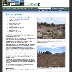
There are occasional cliffy or vegetated areas to find your way around but mostly it's just wide open. (Jerry Adams) Just aim yourself to the North of Ball Butte. Try not to step on the few alpine plants. (Jerry Adams) Spring below Broken Top trail. Nice camp sites with Broken Top looking down on you. Broken Top Trail #10, Deschutes NF, Oregon - Hiking trip. Central Oregon - Broken Top Trail.
Southern oregon. Devil's Staircase Wilderness Passes U.S. Senate With Unanimous Consent. Document Actions Legislation will designate nearly 30,000 acres in the Oregon Coast Range.
20 Favorite Oregon Hikes. Oregon. Central oregon. Diamond Creek Falls, Lane County, Oregon. Diamond Creek harbors a pair of large waterfalls, and fortunately at least one is easily accessed.
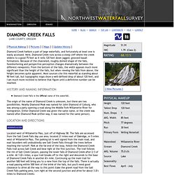
Here, Diamond Creek runs across a steep cliff where the creek widens to a good 75 feet as it veils 120 feet down jagged, grooved basalt formations. Because of the channeled, roughly domed shape of the falls, foreshortening and perspective perception changes dramatically between the different viewpoints. From the bottom of the falls, the width appears much more significant than the height of the falls, but when viewing the falls from above, the height becomes quite apparent. Most sources cite this waterfall as standing about 90 feet tall, but topographic maps show a well-defined drop of about 120 feet, and I am much more inclined to believe that figure until a definitive number can be reached. Willamette National Forest - Salt Creek Falls Trail/ Diamond Creek Falls Loop. The Salt Creek Falls / Diamond Creek Falls Loop is an excellent snowshoe destination due to the lower elevation and often icy conditions.
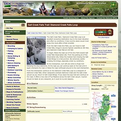
Cross-country skiers would most enjoy this route after a fresh snowfall. From the Salt Creek Sno-Park, you can travel to Salt Creek Falls, Oregon’s second highest waterfall at 286 feet, and Diamond Creek Falls at 100 feet. To begin, follow the road out of the Sno-Park toward Salt Creek Falls Observation site. From the parking lot of the Observation site, follow the marked trail crossing the Salt Creek Bridge to a trail junction. Be extremely careful crossing the bridge, especially under icy conditions. Willamette National Forest - Marilyn Lakes Loop. This route follows the Gold Lake Road approximately a half mile, then descends westward on a marked trail to the south end of Upper Marilyn Lake.
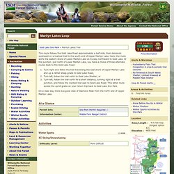
Here, the route skirts the eastern shore of Lower Marilyn Lake on its way northward to Gold Lake. At the junction, just north of Lower Marilyn Lake, you have a choice of three alternate routes back to the Gold Lake Road: Turn right and follow the trail traversing the east shore of Upper Marilyn Lake and up a rather steep grade to Gold Lake Road; Turn left, follow the trail north to Gold Lake Shelter; or Turn left, follow the trail north for a short distance, turning right at a trail junction, and follow the marked trail east to Gold Lake Road.
This latter route avoids the uphill grade on your return trip back to Gold Lake Sno-Park. On a clear day, there is a good view of Diamond Peak from the north end of Upper Marilyn Lake. Willamette National Forest - Winter Recreation Area: Willamette Pass. Willamette National Forest - Winter Sports:XC Skiing/Snowshoeing. Come travel through our winter wonderland by snowshoes or cross-country skiis.
Sno-Parks along each of our major travel corridors serve as launching points for well-marked winter trail networks. While visitors are free to travel on skiis or snowshoes anywhere on the forest, the Sno-Parks offer the safest and most convenient place to get off the busy highways, plus our marked trail networks branching out from the snoparks make traveling easier. Ski trails are marked with blue diamond confidence symbols along each route; snowmobile trails are marked with orange diamon... Ski trails are marked with blue diamond confidence symbols along each route; snowmobile trails are marked with orange diamonds.
Please use our Winter Recreation Maps for the Santiam Pass and Willamette Pass areas for navigating our winter trails. Portland hiking guide: The 20 best places to hike in the city. When we talk about "hiking around Portland," we're not often talking about Portland.
Instead, we're drawing a much broader geographical range, one that encompasses the Columbia River Gorge, Mount Hood and the city's surrounding suburbs. There are plenty of amazing hikes out there, but what about all the trails in Portland proper? With such a green reputation, it should come as no surprise that forests and trails are interwoven throughout Portland's urban makeup.
They ensure opportunities galore to hike through secluded pockets of nature - all without leaving the city. Portland hiking guide: The 20 best places to hike in the city. Portland hiking guide: The 20 best places to hike in the city. Portland hiking guide: The 20 best places to hike in the city.