
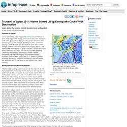
2011 Christchurch earthquake. New Zealand earthquake: Depth and location key. 22 February 2011Last updated at 08:28 By Jonathan Amos Science correspondent, BBC News New Zealand sits astride a major plate boundary.
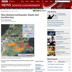
Tuesday's quake was less energetic but more destructive than September's It is in the nature of earthquakes that they tend to cluster in space and time. The Japan Earthquake, Tsunami and Nuclear Crisis: In-Depth Reports. NewsMOX Battle: Mixed Oxide Nuclear Fuel Raises Safety QuestionsOne of the troubled Fukushima Daiichi reactors contains a blend of uranium and plutonium fuel that may soon find use in the U.S.
Does it pose more risks than standard uranium fuel? FeaturesWhat You Need to Know about the Japan Nuclear Crisis [Updated]Confused by the fast-changing pace of events? Here are the key points to know NewsNuke Reboot: Physicists List Lessons to Be Learned from Japan's Nuclear CrisisFor starters, retrofits could make U.S. reactors safer--and maybe even make nuclear power more palatable FeaturesSafety Concerns Often Amount to Status Quo at U.S. Nuclear Industry's Aging ReactorsLeaks, burst cooling pipes, faulty controls, misplaced fuel rods and engineers' warnings about design flaws have done little to slow down approvals for continued operation of the nation's aging nuclear plants NewsCould the Recent Pacific Megaquakes Trigger a West Coast Temblor?
Sedimentary basin. Cenozoic sedimentary basins in the U.S.
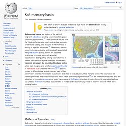
(from USGS) Methods of formation[edit] Sedimentary basins form primarily in convergent, divergent and transform settings. Convergent boundaries create foreland basins through tectonic compression of oceanic and continental crust during lithospheric flexure. 21 Scary Statistics About The 2011 Japan Earthquake. A few scary & depressing facts about the 2011 Tōhoku earthquake and tsunami: The Earthquake Magnitude of the quake: 9.0 Energy released by the quake: 480 megatons (a magnitude 9.0 earthquake releases as much energy as 32,000 magnitude 6.0 earthquakes)
Tsunami Factfile: Learn about the tsunami that struck Japan in March 2011. By Beth Rowen and Catherine McNiff Tsunami in Japan Japan was hit by a 9.0 magnitude earthquake on March 11, 2011, that triggered a deadly 23-foot tsunami in the country's north.
The giant waves deluged cities and rural areas alike, sweeping away cars, homes, buildings, a train, and boats, leaving a path of death and devastation in its wake. Video footage showed cars racing away from surging waves. Japanese Earthquake 2011. What?
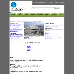
An earthquake measuring 9.0 on the Richter Scale struck off Japan's north-east coast, about 250 miles (400km) from Tokyo at a depth of 20 miles. When? Fast Facts about the Japan Earthquake and Tsunami. Japan tsunami: Astonishing satellite image shows how 1.5million tonnes of debris is being swept towards the US. New computer model predicts thousands of tonnes will hit shores this year Detritus stretches across 4,000 miles of the north Pacific as it heads east Residents in Washington state advised on what to expect on their beaches But officials say it is highly unlikely any human remains will be discovered By Simon Tomlinson PUBLISHED: 09:45 GMT, 2 May 2012 | UPDATED: 16:04 GMT, 2 May 2012.
Plate Tectonics, Tectonic Plates Information. There are a few handfuls of major plates and dozens of smaller, or minor, plates.
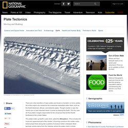
Six of the majors are named for the continents embedded within them, such as the North American, African, and Antarctic plates. Though smaller in size, the minors are no less important when it comes to shaping the Earth. The tiny Juan de Fuca plate is largely responsible for the volcanoes that dot the Pacific Northwest of the United States.
Understanding the Christchurch earthquake: building damage. There are many puzzles as to why some of Christchurch’s buildings have survived the 6.3 earthquake of February 2011, and others have not.

However, a combination of observations plus document-searching does provide some answers. In terms of magnitude, this was just a moderate earthquake, but the local effects on Christchurch have been huge because of its proximity and shallowness. Even within Christchurch, location was of huge importance, but there is more to it than that. It seems that we do indeed have very stringent building codes in New Zealand.
Not only are the codes stringent, but they are enforced. 2011 Tōhoku earthquake and tsunami. The 2011 earthquake off the Pacific coast of Tōhoku (東北地方太平洋沖地震, Tōhoku-chihō Taiheiyō Oki Jishin) was a magnitude 9.0–9.1 (Mw) undersea megathrust earthquake off the coast of Japan that occurred at 14:46 JST (05:46 UTC) on Friday 11 March 2011,[4][9][10] with the epicentre approximately 70 kilometres (43 mi) east of the Oshika Peninsula of Tōhoku and the hypocenter at an underwater depth of approximately 29 km (18 mi).[4][11] The earthquake is often referred to in Japan as the Great East Japan Earthquake (東日本大震災, Higashi nihon daishinsai)[12][13][fn 1] and is also known as the 2011 Tōhoku earthquake,[28] and the 3.11 earthquake.
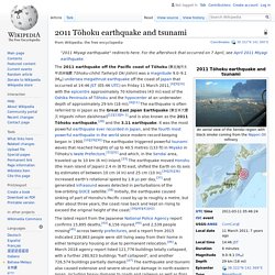
Early estimates placed insured losses from the earthquake alone at US$14.5 to $34.6 billion.[53] The Bank of Japan offered ¥15 trillion (US$183 billion) to the banking system on 14 March in an effort to normalize market conditions.[54] The World Bank's estimated economic cost was US$235 billion, making it the costliest natural disaster in history.[55][56] Science Highlights 2010 - UNAVCO Event Response - Mw=8.8 Chile Earthquake Feb. 27, 2010. Relevant Data Supersite UNAVCO is hosting the GEO (Group on Earth Observations) Supersite on the 2010 Chilean earthquake, featuring a variety of maps, images, and data.
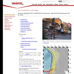
UNAVCO Event Response Forum For information on accessing data including high rate GPS, SAR data, seismic data from the PBO network, UNAVCO GPS equipment availability, and borehole strainmeter data from the PBO network go to our Event Response Forum. GPS Data Available from NASA/GNN Station SANT for Earthquake UNAVCO operates the NASA/GGN GPS station near Santiago (SANT), which is a high rate station set to log at 1 Hz (Fig. 12).
Ground Truth Trekking Blog » Largest Earthquakes since 1900. Understanding the Christchurch Earthquake of 22 Feb 2011: magnitude, location and impact. Last September, those of us who live in Christchurch experienced a 7.1 earthquake. Since then, we have referred to that as ‘the big one’, confident that we would never again experience anything similar. In that September quake, there were no lives lost, but there were many houses badly damaged and destroyed. Within days, most of us were able to get on with our lives, although scratch below the surface and it was immediately obvious that many people were still struggling with the upheaval to their lives.
It wasn’t a case of some people being tougher than others. Understanding the Christchurch earthquake: building damage. There are many puzzles as to why some of Christchurch’s buildings have survived the 6.3 earthquake of February 2011, and others have not. However, a combination of observations plus document-searching does provide some answers. Tectonics of the M7 earthquake near Christchurch, New Zealand. This post was written in response to the Darfield earthquake in September 2010.
The most recent seismic activity is discussed here. [Updated 8th September 1200 GMT – see bottom of post. And check out the PodClast discussion of this earthquake, featuring Kiwi Chris Town, Ron Schott, and myself.] The South Island of New Zealand has just been shaken by a large earthquake, reported as a magnitude 7.0 by the USGS. It appears to be quite a shallow rupture, on the Canterbury Plains close to Christchurch, and the focal mechanism indicates largely strike-slip motion.
Earthquakes and Plate Tectonics. Expert: Haiti quake occurred in complex, active seismic region. January 14, 2010. File:Okhotsk Plate map en.png. New Zealand Earthquakes: locations, depths and tsunami. More detailed investigation of earthquake-related documents has now led me to write something further about earthquakes in New Zealand. The Christchurch Earthquake: tectonic plates and fault lines.
Earthquake Fault Under Tokyo Closer Than Expected, Study Finds.