
Socotra. Socotra (Arabic: سُقُطْرَى Suquṭra), also spelled Soqotra, is a small archipelago of four islands in the Indian Ocean. The largest island, also called Socotra, is about 95% of the landmass of the archipelago. It lies some 240 kilometres (150 mi) east of the Horn of Africa and 380 kilometres (240 mi) south of the Arabian Peninsula.[2] The island is very isolated and a third of its plant life is found nowhere else on the planet. It has been described as "the most alien-looking place on Earth". The island measures 132 kilometres (82 mi) in length and 49.7 kilometres (30.9 mi) in width.[3] Socotra is part of Yemen.
Etymology[edit] In the notes to his translation of the Periplus, G.W.B. History[edit] Map of the Socotra archipelago There was initially an Oldoway (or Oldowan) culture in Socotra. Socotra appears as Dioskouridou ("of Dioscurides") in the Periplus of the Erythraean Sea, a 1st-century AD Greek navigation aid. The islands passed under the control of the Mahra sultans in 1511. Historic regions of the United States. Map showing North American Territorial Boundaries leading up to the American Revolution and the founding of the United States: British claims are indicated in red and pink, while Spanish claims are in orange and yellow.
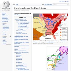
Early map showing claims and grant boundaries. Some colonies seen here are: Nova Scotia, First Province of Maine, Plymouth, Massachusetts Bay, New Netherland, New Sweden, and Lord Baltimore's Land (Maryland) This is a list of historic regions of the United States. Colonial era (before 1776)[edit] The Massachusetts Bay Colony French settlements and forts in the so-called Illinois Country, 1763, which encompassed parts of the modern day states of Illinois, Missouri, Indiana and Kentucky) A proposal for the creation of Westsylvania was largely deterred by the Revolutionary War The Thirteen Colonies[edit] Pre-Revolutionary War regions[edit] {* -indicates failed legal entities} New England region[edit] Mid-Atlantic region[edit] Southern region[edit] Southwestern region[edit] Salar de Uyuni.
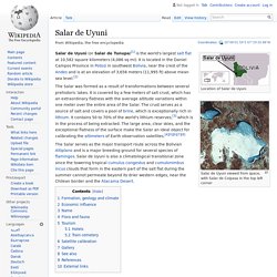
Coordinates: Location of Salar de Uyuni Salar de Uyuni viewed from space, with Salar de Coipasa in the top left corner The Salar was formed as a result of transformations between several prehistoric lakes.
It is covered by a few meters of salt crust, which has an extraordinary flatness with the average altitude variations within one meter over the entire area of the Salar. The crust serves as a source of salt and covers a pool of brine, which is exceptionally rich in lithium. The Salar serves as the major transport route across the Bolivian Altiplano and is a major breeding ground for several species of flamingos. Formation, geology and climate[edit] The salar is composed of a salt surface crust overlying brine saturated sediments. Salar de Uyuni is part of the Altiplano of Bolivia in South America. The geological history of the Salar is associated with a sequential transformation between several vast lakes. Economic influence[edit] Salt production at the Salar Name[edit] Flora and fauna[edit]