
DeepMatrix 3D multi-user system. This article or section is a stub.
A stub is an entry that did not yet receive substantial attention from editors, and as such does not yet contain enough information to be considered a real article. In other words, it is a short or insufficient piece of information and requires additions. 1 Introduction. X3D_Standard_notes. X3d. Summary Use this extension to render x3d content directly in MediaWiki.
All content between <x3d> and </x3d> tags is passed to a Java applet. No additional plugin is required on the client side. X3D-Edit 3.3 Authoring Tool for Extensible 3D (X3D) Graphics. Overview | Acknowledgements | Books | Chat | Downloads | Features | Issue Tracking | Licenses | Mailing Lists | Plugins | Source | Support | Visualization | X3D Resources | Contact X3D-Edit is an open-source Extensible 3D (X3D) Graphics authoring tool for simple error-free editing, authoring and validation of X3D scenes.
Overview The X3D-Edit 3.3 Authoring Tool for Extensible 3D (X3D) Graphics supports the creation, checking, display and publication of X3D scenes. It is written in open-source Java and XML using the Netbeans platform, making it suitable both as a standalone application and as a plugin module for the Netbeans integrated development environment (IDE). X3D-Earth Globe Under Development. Frequently Asked Questions - K-3D. The making of Kelpie College's 3D environment representing Pict Harbour campus in X3D. Introduction Background Some time ago, a simple VRML model was made of Pict College campus.
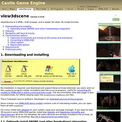
ARToolKit Home Page. ARToolKit is a software library for building Augmented Reality (AR) applications.
These are applications that involve the overlay of virtual imagery on the real world. For example, in the image to the right a three-dimensional virtual character appears standing on a real card. It can be seen by the user in the head set display they are wearing. When the user moves the card, the virtual character moves with it and appears attached to the real object.
This website contains a link to the ARToolKit software, projects that have used ARToolKit, sample ARToolKit applications, a discussion group and full documentation. ARToolKit was originally developed by Dr. For information on this page, contact Philip Lamb. View3dscene. View3dscene is a VRML / X3D browser, and a viewer for other 3D model formats. 1.
Downloading and installing No installation is required. Just download and unpack these archives wherever you want, and run the view3dscene program inside. About this book. About this book Java 3D is a client-side Java application programming interface (API) developed at Sun Microsystems for rendering interactive 3D graphics using Java.
Using Java 3D you will be able to develop richly interactive 3D applications, ranging from immersive games to scientific visualization applications. Who should read it? Java 3D Programming is aimed at intermediate to experienced Java developers. Analyzing and optimizing your model for the 3D Web — X3DOM 1.4.0 documentation. The InstantReality platform provides its users tools to help them better understand and optimize their (possibly large) 3D data sets.
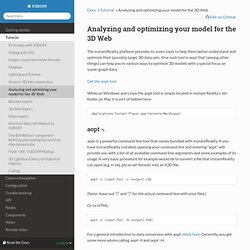
One such tool is aopt that (among other things) can help you in various ways to optimize 3D models with a special focus on scene-graph data. Get the aopt tool While on Windows and Linux the aopt tool is simply located in Instant Reality’s bin folder, on Mac it is sort of hidden here: MeshLab - Browse /meshlab/MeshLab v1.3.2.
_schule.pdf (application/pdf Object) White_Dune - graphical VRML97 Editor and animation tool. MeshLab - Browse /meshlab/MeshLab v1.3.2. Download. LandscapeCreating. Search public documentation: LandscapeCreating 日本語訳中国翻译한국어 Interested in the Unreal Engine?
Visit the Unreal Technology site. Free Graphics software downloads. Savage X3D Examples Archive, Environment, Sea State, Move Sea By Extrusion 13. Open Source Haptics - H3D.org. Data Available Through Unidata. What Is It?

The Data Usage Guide is a flowchart designed to illustrate: 1) the type of data access methods available; and 2) the display capabilities of the Unidata visualization packages for each data type. Direct links/access to the pertinent data type formats and access protocols are also provided to aid in quick data discovery. The Data Usage Guide is a great place to start if you are unsure of the capabilities of the data types Unidata has to offer. How It Works Each Data Type, when selected, expands to a diagram that illustrates the current display capabilities and maps out the process of how to use that type of data with Unidata tools. Additionally, every object provides information about the data or format, and can be followed to find examples of how the data will look when visualized with Unidata clients.
Haptic2-2012. Download 3d Modelling Software. Submarine X3D. X3D for Web Authors: Slidesets. Now available: slidesets for our next book X3D for Advanced Modeling including Computer-Aided Design (CAD), Distributed Interactive Simulation (DIS) and X3D Earth Geospatial Component. Slidesets: X3D for Web Authors Over 1200 slides are freely provided to illustrate the material in X3D for Web Authors. These course notes are suitable for teaching X3D to students with or without prior programming experience. Award. The combined X3D for Web Authors text, slidesets, examples and X3D-Edit authoring tool won the Computer Graphics Educators Material Source (CGEMS) jury award for best materials 2008. These slidesets are offered under an open-source license, and can be discussed on the x3d-educators mailing list. Note that if you are printing the .pdf slides, only print either the first or second half of each file.
X3DV. This article or section is a stub. A stub is an entry that did not yet receive substantial attention from editors, and as such does not yet contain enough information to be considered a real article. In other words, it is a short or insufficient piece of information and requires additions. Page created by Flux, 22 July 2011Last modified by Flux, 22 July 2011 1 X3DV Definition.
X3D, H-Anim, and VRML97 Specifications. Open Source Haptics - H3D.org. Features. Usage and Markets The OpenSceneGraph is open source, real-time graphics middle-ware used by application developers in fields that range from visual simulation (flight, marine, vehicle, space simulator) to virtual and augmented reality, to medical and scientific visualisation, to education and games. Cross Platform The OpenSceneGraph is cross platform running on small devices such as embedded graphics platforms to phones, tablets that use OpenGL ES, to laptops and desktops using OpenGL all the way up to dedicated image generator clusters used in full scale simulators and immersive 3D displays. Licensing The OpenSceneGraph is published under the OpenSceneGraph Public License, which is a relaxation of the Less GNU Public License (LGPL) that permits usage in commercial application that require static linking or embed systems. Technology The OpenSceneGraph is written in Standard C++, taking advantage of the standard template library (STL) for containers.
Creating Web3D-Content (VRML/ X3D) using Blender. Creating Web3D-Content (VRML/ X3D) using Blender The VRML/X3D exporter turns Blender in a real authoring application for Web3D content. As both the VRML and X3D exporters use the same options, this help page applies to both of them. Große 3D-Stadtmodelle im Internet - CityGML.de. X3D and Virtual Scene Graphs. The Xj3D Project. SRTM-Daten. DTED files. DTED (Digital Terrain Elevation Data) AIVDM. Digital Terrain Elevation Data (DTED) - Part 5, HRTI. Greetings Mission Planners, If you're interested in the data characteristics of the SRTM data then check out: Slides 13 and 14 do an especially good job of quantifying the shortfalls of the SRTM data - or rather of the SRTM instrument.
On the links page I've added a link to Terraserver-USA, which provides quick access to view the USGS Digital Raster Graphics and Digital Ortho Quads. You can search for a location with a street address, view the image date of the DOQ and format a page to send to the printer. Here's a link to 1600 Pennsylvania Avenue. Interactive 3D Based on X3D and Vrml.