
Plotting Latitude / Longitude with Google Maps. Google Map, introduced in 2005, allows the mapping of latitute/longitude coordinates using its Application Program Interface (API).
The API allows programmers to access the functionality of a pre-built software module. It includes a set of routines that can be called by the programmer to perform certain functions. The following is a list of all Google Maps class, types, and functions: The programming language that we will be using is called ECMAScript/JavaScript. It is an interpreted programming language that can reside within an HTML file. To use Google Map's API, you must request a key from: Sign Up for Google Maps API You will need to provide the web address where the HTML file that calls Google Maps will reside.
After you agree to the terms of use, Google will supply you with a code that looks something like this: ABQIAAAAPI4wou--an7ZjU7fKLQYuxS0RxRP7CMh6pLWx2ONXFqzrBhWlhRskzuOhkrZp7zdul_1OmuqEfNCq This is my code. The Code <! Function load() { if (GBrowserIsCompatible()) { Tools For Google Earth. My Google Maps tool. Interactive map: iMapBuilder map software. Create editable interactive maps, flash map and clickable image maps. Google Maps Area Calculator Tool. Output : Current Area 0 m² 0 km² 0 acres 0 hectare 0 square feet 0 square miles 0 square nautical miles Current Perimeter Output : Total Area(s) 0.00 m² 0.00 km² 0.00 acres 0.00 hectares 0.00 feet² 0.00 square miles 0.00 square nautical miles Description This tool allows you to use Google Maps to define an area and then find out the measurement of the enclosed area.
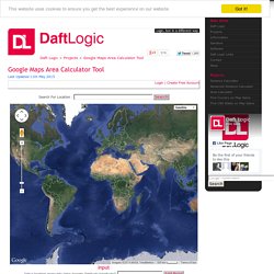
How to Use Click multiple times around the map to define an areaThe calculated area will then be displayed below the map Other Options Click [Delete Last Point] to remove the last point clickedClick [Clear All Points] to remove all areas drawnClick [Generate KML] to generate a KML file representing the last area drawn. Login to Save and Load Maps You can create an account for free from which you can save and load saved areas unique to you.
Relevant Links Further Uses and Ideas Enable clicking inside the areaAllow markers to be toggled on and offAllow upload a KML file and calculate any areas of polygons inside Version History. Area Calculator Using Maps. This planimeter tool can be used to measure the enclosed area of a defined polyline on a map.
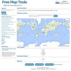
Instructions To use the area calculator tool: Zoom and pan the map to find the area of interest Click on the map to place a vertices for the polyline Click as many time as necessary to define the polyline The area enclosed will them be output in square meters and square kilometers You can click the [Delete Last Point] button if you make a mistake or click [Clear All] points to remove all points from the map and start again.
You can also reposition the markers after they have been placed on the map by dragging and dropping them. Information The area calculator tool allows you to find out the area that is enclosed inside a closed polyline overlaid on a map. Benchmarks A measurement of Lough Neagh in Northern Ireland. Future Uses and Ideas Allow the user to change the colour of the polylines and area shading (including transparent) Allow the area to be saved for later use Version History.