

TechTV – Henry Jenkins on Mapping. Resource Center » Knowledge Mapping. Knowledge mapping offers a tremendous resource for deliberation about issues or problems.
We can lay out what we collectively know, visually clarifying relationships among the relevant factors, actors, sectors, etc., involved with the problem being deliberated. Knowledge mapping is a general term that covers… mapping public issues ('social messes,' 'wicked problems')(e.g., Robert Horn [see 'Focus on Public Issue Mapping' below]) mind maps (e.g., Inspiration software)pattern languages (e.g., Christopher Alexander)Dialogue Mapping (e.g., CogNexus Institute)Graphic Facilitation (e.g., David Sibbet)geographical information mapping (GIS – Geographical Information Systems) and may include more traditional visuals such as… Urban tapestries. In recent years the dominant metaphor for pervasive location-based services has been a commercial one which posits people merely as consumers of pre-authored content chosen and served to them by network providers.
Such services are typified by the prevalence of mobile tourist guides, listings services and restaurant guides – all of which have their uses, but essentially do little more than make pre-existing services of print and broadcast media available via wireless devices. Real city life is richer and more complex than this, relying as much on social networks, personal experiences and chance interactions and connections.
We believe that pervasive wireless/mobile platforms should attempt to reflect this richness and complexity, rather than re-purposing solutions designed for a different age. Urban Tapestries aims to privilege the experience of the individual over typical location-based services which control and author the user experience. What Might Authoring Entail? Spying With Maps: Surveillance Technologies and the Future of Privacy - Mark Monmonier. Neogeography. The abstract is as follows: “Web 2.0, specifically The Cloud, GeoWeb and Wikitecture are revolutionising the way in which we present, share and analyse geographic data.
In this paper we outline and provide working examples a suite of tools which are detailed below, aimed at developing new applications of GIS and related technologies. GeoVUE is one of seven nodes in the National Centre for e-Social Science whose mission it is to develop web-based technologies for the social and geographical sciences. The Node, based at the Centre for Advanced Spatial Analysis, University College London has developed a suite of free software allowing quick and easy visualisation of geographic data in systems such as Google Maps, Google Earth, Crysis and Second Life. On another note, Andy, myself and another researcher Joel Dearden are also working on some agent-based models in Second Life. Screen Shot of our Game of Life Model in Second Life: Pedestrian Evacuation Model in Second Life:
Po Ve Sham – Muki Haklay’s personal blog. Tracing Mobility. The New Cartographers. We no longer go to maps to find out where we are.
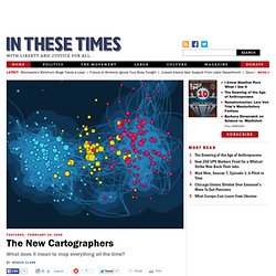
Instead, we tell maps where we are and they form around us on the fly. It’s flu season, and you’re feeling woozy. Have you caught that thing that’s going around? To find out, head over to Who is Sick? , a Google map-based tool that lets users report their symptoms. Or maybe you’re depressed. Maps are everywhere these days. Like other technological innovations, this trend gives with one hand and takes with the other. For some, mapping has become a vibrant new language–a way to interpret the world, find like-minded folks and make fresh, sometimes radical, perspectives visible. Google builds it, people come Credit former President Bill Clinton for kicking this all off.
Google Earth is the crown prince of the search engine’s mapping realm. The program comes with its own built-in “layers” that pinpoint the locations of parks, landmarks and boundaries. Mapping the mappers Google isn’t the only site offering mashups–just the most high-profile one. Maps for Driving Change. Author: Peter Manzo Stanford Social Innovation Opinion Blog, Jun 12, 2008 Steve Jobs unveiled the new iPhone 3-G, to oohs and aahs.
One of its most impressive features is a pairing of GPS and mapping that allows users to instantly locate themselves and search for nearby items of interest – restaurants, shops, etc. What will really impress me, though, is when we’re all able to see more information about people and resources. I’d bet anyone reading this can quickly search for a Starbucks, or some other commercial resource, anywhere around the globe. Geoweb. The Geospatial Web (pronunciation: 'gēō-spãy-shee-ăl wěb') or Geoweb are computer networks which pair geographic (e.g. two-dimensional maps) or geospatial (e.g. three-dimensional pictures) underlay systems with Geotag overlay systems for the purpose of connecting users with other network locations.
Today's free and popular Geobrowsers are examples of simple Geoweb service implementations. Complex Geoweb services provide users access to applications and files, within the context of specific physical locations on earth. The concept of a Geospatial Web may have first been introduced by Dr. Charles Herring in his US DoD paper, An Architecture of Cyberspace: Spatialization of the Internet, 1994, U.S. Army Construction Engineering Research Laboratory ( WikiMiniAtlas.