
ORBIS. Anthropomorphic and Zoomorphic Satirical Maps:#3. Australian Big Business Octopus, 2010 Here is our friend, the Octopus, again, which features in many of the satirical map cartoons of yesteryear.
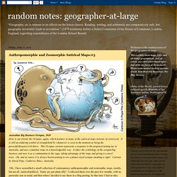
It is still an enduring symbol of stranglehold by whomever is seen in the moment as being the powerful/despotic/evil-doers. This Octopus cartoon represents a response to the proposed mining tax in Australia, and uses a familiar trope in a knowledgeable way. It takes the symbology of the octopus/big business and uses it as a continuation to the saga, taking advantage of the trope and giving it a novel twist.
Oh, and of course it is always heartwarming to see a planet-sized octopus smoking a cigar! Anthropomorphic and Zoomorphic Satirical Maps:#1. Detail of India from “The Illustration of The Great European War No.16 -- A humorous Atlas of the World,” by Tanaka, published in Japan, 1914. A rare satirical / political map f rom the Asian Perspective. There is a whole genre in map-making that entails using anthropomorphic or zoomorphic figures in maps. This is a tradition that began in the mediaeval times and continues until the present day.
There are several sub-genres of these anthropomorphic maps, one of which is the satirical or political cartoon type map which uses animals or people to create the outline borders of nations. These are very cleverly done, and are often brilliant commentaries on events or circumstances of the day, usually espousing a partisan point of view of the facts. I have (way too) many examples of these kinds of maps, some of which I include here, but this is by no means an exhaustive collection. Unconventional (yet informative!) Maps of the Big Apple. Here are some cool maps on New York City (and yes, I am aware that for the most part, this means Manhattan below 96th Street!
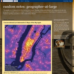
But what can one do?). Ahhh....New York City, aka The Big Apple. Or “the big stinky apple,” as one of my nephews calls it (btw, he’s NOT a New Yorker, obvio!). With a few exceptions, they are all relatively recent maps. I couldn’t resist adding in a couple of vintage examples, such as the Beerdom Map of the Lower East Side (1885).
Maps Showing Basic Facts about NYC 3-D Map of Lower Manhattan, overlain on an historic map Google Earth has added part of the David Rumsey Historical Map Collection to their software. Rich Guy Map “Where are all the rich, single guys in Manhattan? NYC Photo-taking maps Taking city maps and overlaying them with the frequency of photo taken and posted to Flickr by local residents as compared to tourists. Anthropomorphic and Zoomorphic Satirical Maps:#2. Rediscovering African Geographies. The Catalan Atlas , 1375, by Abraham Cresques – detail showing Northern Africa, with a depiction of The King of Mali and Lord of Guinea, Mansa Musa, 1312-1337, seated on his throne in a stately fashion with crown, orb, and scepter, with the inscription: The richest and noblest King in the world.
“This ‘atlas’ was the work of a family of Catalonian Jews who worked in Majorca at the end of the 14th century and was commissioned by Charles V of France at a time when the reputation of the Catalan chartmakers was at its peak. King Charles requested this map from Peter of Aragon, patron of the best Majorcan mapmaker of the time: Abraham Cresques. The ‘atlas’ that resulted has subsequently been called ‘the most complete picture of geographical knowledge as it stood in the later Middle Ages.’ The crowned black man holding a golden disk is identified as Musse Melly , ‘lord of the negroes of Guinea’ - in fact, Mansa Musa, of fabulous wealth.
(excerpted from Henry Davis Consulting at Africa . Boston_area_college_town_map.png (PNG Image, 2213×2010 pixels) Map of the Week 9-19-2011: Mecca at the Center of the World. Equidistant azimuthal projection, centered on Mecca, and green lines showing the Qibla (shortest direction to Kaaba in Mecca, 21° 25′ 21″ N, 39° 49′ 34″ E) The problem with this projection is that is shows correctly directions FROM Mecca, but not directions TO Mecca, which is what is needed to know in which direction to pray.
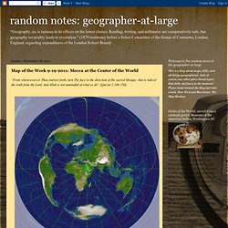
For that we need an entirely different kind of projection, a Retro-Azimuthal Projection. “Qibla (or qiblah; Arabic: قبلة) is an Arabic word for the direction that should be faced when a Muslim prays during Salah, the Islamic practice of formal prayer, usually performed five times a day. Since 622 AD, that direction has been towards Kaaba (The Cube), a cube-shaped building in Mecca, Saudi Arabia, which is the most sacred site in Islam. But there are quibbles about qibla. A July 19 CNN article comments, “Indonesian Muslims have been praying in the wrong direction, the country's highest Islamic authority has said. Qibla has always been somewhat problematic. Thomas P.M. Barnett's Globlogization - High Resolution Map. The Evolving Neighborhoods Along the Marathon - Interactive Map.