
Hyperlink - Leaflet zoom onto location using link and map.setView. Numbered Markers in Leaflet (JS Mapping) List markers and pan to clicked items. Blog · justinmanley.io. Leaflet.toolbar, a JavaScript library for building flexible and extensible toolbars for Leaflet maps, is just released and available on npm.
Leaflet.toolbar is an effort to extend the excellent Leaflet.draw plugin and to enable new kinds of map / user interactions. In particular, Leaflet.toolbar aims to: Decouple the actions exposed by a toolbar from its overall behavior and appearance;Enable both control-style and popup-style toolbars out of the box;Make it easy for library developers to define new kinds of toolbars;Be easy for application developers to instantiate;Remain interoperable with Leaflet.draw. Geojson.io. Creating responsive maps with Leaflet, Google Docs. Note: This is cross-posted from Lee’s data journalism blog, which you can read over there by clicking here.
Quick: Name five people you know who don’t have a smartphone. Stumped? Yeah, me too. The fact is more and more people have smartphones and are using them to keep up with the world. What does that mean for news app developers? One great way to do this is creating apps through responsive design. Then we simply add, rearrange, subtract or tweak features on a web page based on the size of the browser the user has when they are viewing the app. Maps can be difficult to manage on mobile platforms, especially when you add in legends, info boxes, etc. Mapbox. By Sir Arthur Conan Doyle Scroll ▼ 221b Baker St.
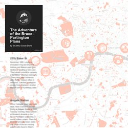
November 1895. London is shrouded in fog and Sherlock Holmes and Watson pass time restlessly awaiting a new case. "The London criminal is certainly a dull fellow," Sherlock bemoans. Aldgate Station Arthur Cadogan West was found dead, head crushed in on train tracks at Aldgate Station at 6AM Tuesday morning. Mapbox styleguide. LightBox and Leaflet to create an image gallery. Add multiple markers in leaflet.js. Leaflet.js map with marker options. Leaflet panTo (or setview) function? Zeck's Blog » Leaflet : gérer les layers. Après avoir créé une carte Leaflet (Leaflet, créer votre carte rapidement) et placer des markers (Leaflet : création massive de markers), voyons comment gérer les layers, soit savoir comment changer le fond de carte à la volée ou afficher/masquer les markers qui sont présents sur la carte.
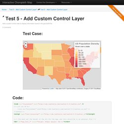
Fonds de carte Il est possible de changer de fond de carte à la volée suivant le type de représentation que l’on souhaite. Pour des question de lisibilité, de représentation, ou simplement… pour le fun ! Le fond de carte, c’est l’ensemble des ’tiles’ qui sont mises à notre disposition par les fournisseurs comme Google Maps, OSM ou Cloud Made. <b class="icon-leaf"></b> Test 5 - Add Custom Control Layer. Copyright © 2013 Jeremy Iglehart Permission is hereby granted, free of charge, to any person obtaining a copy of this software and associated documentation files (the "Software"), to deal in the Software without restriction, including without limitation the rights to use, copy, modify, merge, publish, distribute, sublicense, and/or sell copies of the Software, and to permit persons to whom the Software is furnished to do so, subject to the following conditions: The above copyright notice and this permission notice shall be included in all copies or substantial portions of the Software.
Creating your own layer controller to add and remove layers from a leaflet.js map - Rowan Winsemius. One of the questions I’ve seen around a little bit is how I can I set up my own layer controller for leaflet.js.
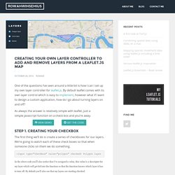
By default leaflet comes with its own layer control which is easy to implement, however what if I want to design a custom application, how do I go about turning layers on and off? Cartographie avec les couches Géoportail/IGN et Leaflet (cartographie, ign, javascript, performances, sig, vtt) Comme je le mentionnais dans mon dernier billet, les cartes sont un élément central dans mon dernier projet personnel sur le VTT dans le Revermont et j‘ai cherché (et je cherche encore) à soigner au maximum cet aspect.
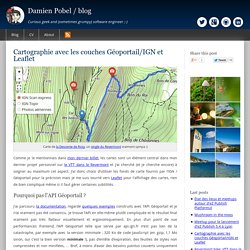
J’ai donc choisi d‘utiliser les fonds de carte fournis par l’IGN / Géoportail pour la précision mais je me suis tourné vers Leaflet pour l'affichage des cartes, rien de bien compliqué même si il faut gérer certaines subtilités. Pedro's Tech Mumblings: Custom Map Tiles (Part 2 - TileMill) In my previous post I've shown a really simple way of overlaying custom map tiles on top of Bing Maps using MapCruncher.
One of the problems with that approach is that it only works for raster files. If one needs to do more complex stuff like creating tiles with data from shapefiles, kml or databases then a different method/tool must be used. We have three challenges here: Change L.Control.Zoom position to 'bottomleft' - Google Groupes. Leaflet Panel Layers. Labs EasyBlog.It. Leaflet.Control.Search. Bmcbride/bootleaf. Utiliser Bootstrap Map pour vos applications JavaScript ArcGIS. Si vous avez parcouru ou utilisé la documentation de l'API JavaScript ArcGIS, vous aurez constaté qu'en rédigeant quelques lignes de code HTML/Javascript, on peut réaliser très simplement une première application web cartographique.
L'étape suivante consiste généralement à ajouter des fonctionnalités plus avancées. Là encore, avec la richesse des exemples fournis dans la documentation cela reste assez simple de reprendre les morceaux de code adéquats pour les adapter à vos besoins. Une fois les premiers tests fonctionnels réalisés, il vous faudra probablement lever les mains du clavier et réfléchir sérieusement au design de votre application. Une connexion internet sur deux se faisant à partir d'un appareil mobile, il ne faudra pas oublier l'aspect "responsive" de votre application pour qu'elle s'adapte à tous les types d'écrans. C'est généralement là que ça se complique, et encore, vous n'avez pas commencé à rédiger vos pages HTML, votre code Javascript et vos styles CSS ! Turbo87/sidebar-v2.
Using Leaflet.js with non-geographic imagery - Oliver Marriott. Hey!
This was written for Leaflet.js 0.5.1, sorry, it might not work anymore but hopefully it's still helpful. Using leaflet.js to pan and zoom a big image. I recently used leaflet.js to embed a large image in a webpage and allow users pan over it and zoom into it. There's a Stack Overflow post about how to do this for a single image, but the anwsers don't have enough detail to make it easy to understand and do. The image I used was of a newspaper article. It's not big enough to need segmentation, but it's too big to show on a page at full scale.
Csessig86/tabletop_to_leaflet. How to interact with leaflet marker layer from outside the map. Yohanboniface/Leaflet.TileLegend. SetStyle() function for GeoJSON features - Leaflet. Ok, since I already asked a very long question about this, but since it didn't get any new replies for a while, and not to get confused in details, I will keep this one simple the best way I can.
If I'm not mistaken, a setStyle function for a named, particular feature would be as follows: ...which would change the color from orange to blue. I'm also aware of the resetStyle() function that will revert the style to the original. This is how I style my GeoJSON: What I want to do is to make just one country blue and the others gray, later in the code. The second thing is, (that's giving me sleepless nights) how do I select just one feature out of a group of GeoJSON polygons to work with? Ajouter un fond de carte IGN à Leaflet.js : la-trace.com – Le Blog. Stefanocudini/leaflet-search. Custom tooltip. Norkart/Leaflet-MiniMap.