
B.C. braces for Japan quake debris. NASA UPGRADES 2012 SOLAR STORM WARNING - LEARN HOW TO PREPARE. Radioactive iodine: Now France detects traces in atmosphere. Oops! Sorry, the page you requested either doesn't exist or isn't available right now! Please check the URL for proper spelling and capitalization. If you're having trouble locating a destination on Yahoo! Ontario to examine FIT energy subsidies. Turkey Earthquake 2011: 7.2 Quake Near Ercis Causes Death, Damage. CNN reports that a 7.2 earthquake has struck Eastern Turkey, making it the most powerful earthquake to hit the country in ten years.
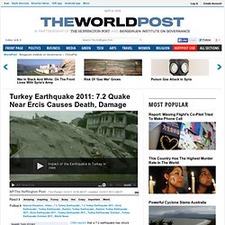
The quake was felt in the provinces of Diyarbakir, Erzurum, Siirt, Mus and Agri, according to Bloomberg News. The USGS reports a second earthquake of 6.0 magnitude, this time in Eastern Turkey. More from the Associated Press: By SELCAN HACAOGLU and SUZAN FRASER, Associated Press ANKARA, Turkey — Cries of panic and horror filled the air as a 7.2-magnitude earthquake struck eastern Turkey, killing at least 88 people as buildings pancaked and crumpled into rubble. Tens of thousands fled into the streets running, screaming or trying to reach relatives on cell phones as apartment and office buildings cracked or collapsed.
"My wife and child are inside! Magnitude 5.6 quake jolts northeastern Japan: NHK. The Secret to A Better Night’s Sleep?

Your Foot. Japan Quake May Have Struck Atmosphere First. The devastating earthquake that struck Japan this year may have rattled the highest layer of the atmosphere even before it shook the Earth, a discovery that one day could be used to provide warnings of giant quakes, scientists find.
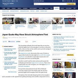
The magnitude 9.0 quake that struck off the coast of Tohoku in Japan in March ushered in what might be the world's first complex megadisaster as it unleashed a catastrophic tsunami and set off microquakes and tremors around the globe. Scientists recently found the surface motions and tsunamis this earthquake generated also triggered waves in the sky. These waves reached all the way to the ionosphere, one of the highest layers of the Earth's atmosphere. Now geodesist and geophysicist Kosuke Heki at Hokkaido University in Japan reports the Tohoku quake also may have generated ripples in the ionosphere before the quake struck. Heki analyzed data from more than 1,000 GPS receivers in Japan.
This story was provided by OurAmazingPlanet, sister site to LiveScience. Earthquakes. Earthquake Lists & Maps. Earthquake Hazards Program: Recent Earthquakes - Last 8-30 Days. NEIC Tour Information The National Earthquake Information Center is located in Golden, CO at: 1711 Illinois Street (on the Colorado School of Mines Campus).
Our mailing address is: U.S.Geological Survey National Earthquake Information Center Box 25046 MS 966 Denver Federal Center Denver, Colorado 80225-0046 Tours are free, by appointment only. A reservation is required. 600 Mile Radius around Yellowstone: Fallout Zone if erruption occurs. Super Volcano Will Challenge Civilization, Geologists Warn.
The eruption of a super volcano "sooner or later" will chill the planet and threaten human civilization, British scientists warned Tuesday.
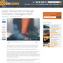
And now the bad news: There's not much anyone can do about it. Several volcanoes around the world are capable of gigantic eruptions unlike anything witnessed in recorded history, based on geologic evidence of past events, the scientists said. Such eruptions would dwarf those of Mount St. Helens, Krakatoa, Pinatubo and anything else going back dozens of millennia. "YELLOWSTONE SUPER-VOLCANO MAY BE IN EARLY STAGES OF ERUPTION. Title: YELLOWSTONE SUPER-VOLCANO MAY BE IN "EARLY STAGES" OF ERUPTION!
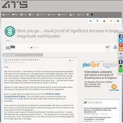
Subtitle: As we review the signs -- especially the huge rock deformations that have occurred -- be advised that geologists have admitted that the Yellowstone Super-Volcano is 20,000 years past due for a major eruption. Rock deformation has already occurred that dwarfs that of Mt. St. Graph of Earthquake Frequency. Here you go ... visual proof of significant increase in large magnitude earthquakes. +7 more posted on Sep, 4 2011 @ 12:54 AM.
The Great Cascadia Earthquake of 2xxx. Cascadia is America's own tectonic version of Sumatra, where the magnitude 9.3 earthquake and tsunami of 2004 occurred.
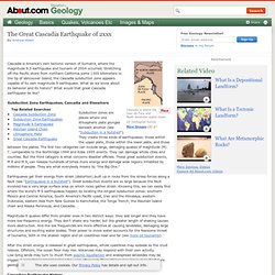
Stretching off the Pacific shore from northern California some 1300 kilometers to the tip of Vancouver Island, the Cascadia subduction zone appears capable of its own magnitude 9 earthquake. What do we know about its behavior and its history? Cascadia subduction zone. Structure of the Cascadia subduction zone Area of the Cascadia subduction zone Coordinates: 45°N 124°W / 45°N 124°W / 45; -124 The Cascadia subduction zone (also referred to as the Cascadia fault) is a subduction zone, a type of convergent plate boundary that stretches from northern Vancouver Island to northern California.
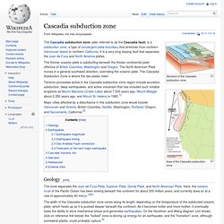
It is a very long sloping fault that separates the Juan de Fuca and North America plates. Tectonic processes active in the Cascadia subduction zone region include accretion, subduction, deep earthquakes, and active volcanism that has included such notable eruptions as Mount Mazama (Crater Lake) about 7,500 years ago, Mount Meager about 2,350 years ago, and Mount St. Major cities affected by a disturbance in this subduction zone would include Vancouver and Victoria, British Columbia; Seattle, Washington; Portland, Oregon; and Sacramento, California.[2] Geology[edit] Ancient stone markers warned of tsunamis. In this March 31, 2011 photo, a tsunami survivor walks past a centuries-old tablet that warns of danger of tsunamis in the hamlet of Aneyoshi, Iwate Prefecture, northern Japan.
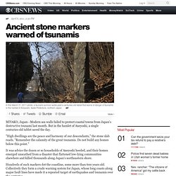
AP MIYAKO, Japan - Modern sea walls failed to protect coastal towns from Japan's destructive tsunami last month. Latest Philippine Headlines, Breaking News, Video, Analysis, Features. A map from the Japan Meteorological Agency (JMA) shows the epicenter and the affected areas of the quake. (JMA) TOKYO, Japan ( UPDATE 3 ) - A massive 8.9-magnitude earthquake hit northeast Japan Friday, setting a nuclear plant ablaze, unleashing a 10-metre tsunami that tossed ships inland and leaving at least 32 people reported dead.
It was the strongest earthquake ever to hit Japan. Pacific Ring of Fire. Tectonic plates of the world The Ring of Fire is an area in the basin of the Pacific Ocean where a large number of earthquakes and volcanic eruptions occur. In a 40,000 km (25,000 mi) horseshoe shape, it is associated with a nearly continuous series of oceanic trenches, volcanic arcs, and volcanic belts and/or plate movements. It has 452 volcanoes and is home to over 75% of the world's active and dormant volcanoes.[1] The Ring of Fire is sometimes called the circum-Pacific belt. Scientists Fail to Link Pacific Rim Earthquake Clusters. The record 8.9 magnitude earthquake that struck north-eastern Japan on Friday (11th March) was unlikely to be linked to the devastating, shallow 6.3 earthquake in Christchurch, New Zealand in February.
The earthquake that has wrecked havoc and destruction in Japan was nearly 8000 times stronger than the Christchurch quake. The Japan earthquake, (130km east of Sendai), was ranked as the fifth-largest earthquake in the world since 1900. Local aftershocks continue to plague both Japan and Christchurch and several large earthquakes have been recorded around the Pacific Rim since Friday. Large after-shock swarms after earthquakes More than 150 after-shocks were recorded in Japan after the big quake, including one measured at 6.8 magnitude that was felt off the east coast of Japan’s main island of Honshu. Earlier a 6.7 quake was recorded in Japan’s Niigata prefecture north-west of Tokyo, causing landslides and destroying houses. Solar flare to ‘paralyse Earth’ in 2013. Nasa Issues 2013 Solar Storm Warning. Big Sunspot 1520 Releases X1.4 Class Flare With Earth-Directed CME UPDATE July 2012 : There is a coronal mass ejection (CME) associated with the July 12 X-class flare.
Solar Storms Building Toward Peak in 2013, NASA Predicts. Solar flares like the huge one that erupted on the sun early today (Aug. 9) will only become more common as our sun nears its maximum level of activity in 2013, scientists say. New Solar Cycle Prediction. + Play Audio | + Download Audio | + Join mailing list. EarthquakesCanada main index - Canada. The M9 Cascadia Megathrust Earthquake of January 26, 1700. At 9PM on January 26, 1700 one of the world's largest earthquakes occurred along the west coast of North America. The undersea Cascadia thrust fault ruptured along a 1000 km length, from mid Vancouver Island to northern California in a great earthquake, producing tremendous shaking and a huge tsunami that swept across the Pacific. Cascadia subduction zone. Weather.