
Open Data. UNdata. Data.gov. American FactFinder. Census Bureau QuickFacts: United States. Opposing Viewpoints database. Data – CISER. CISER is all about Data; finding, depositing, understanding, and working with data in a range of secure environments – whatever level of security is required by the data provider – and more.

CISER Data Archive CISER has an extensive data collection with emphasis on labor, political, and social behavior, demography, economics, and health. The collection includes federal and state census files, administrative records, public opinion surveys, economic and social data from national and international organizations, along with studies compiled by individual researchers. For more information, see the Data Archive Mission Statement. International Terrorism: Attributes of Terrorist Events The International Terrorism: Attributes of Terrorist Events (ITERATE) numeric database is based on international terrorism event chronologies represented in major media, research, news, and information services.
Cornell National Social Survey. PEW Research Center: Download Datasets. Get GSS Data. American National Election Studies. ANES items identified as Restricted Data are not publicly released and are available only under specific contractual conditions.
Access can be requested only through the application process outlined here and only for the purpose of scientific and public policy research. The ANES greatly values the trust our respondents place in us to protect their confidentiality and for this reason, we impose strict legal and electronic requirements. We have tried to minimize the danger of breaches of respondent anonymity in both unrestricted and restricted datasets by aggregating critical variables such as geographic location and occupation/industry up to less specific levels than those provided by the respondent.
We have also devised the contractual procedure described below to ensure that restricted datasets are released only to people who meet stringent conditions designed to protect the anonymity of respondents. Get the Restricted Data Application. Fragile Families and Child Wellbeing Study. Inter-University Consortium for Political and Social Research (ICPSR): Find Data. DISC: Internet Crossroads in Social Science Data.
IPUMS: Integrated Public Use Microdata Series. Harvard Dataverse. Kinsey Institute for Research in Sex, Gender and Reproduction: Data and Codebooks. Social Data - Data Sets for Social Sciences - Research Guides at Vanderbilt University. Statistical Weather and Climate Information. You are here An example of a temperature data analysis that shows high, low, and average temperatures throughout a year.

NCEI offers several types of climate information generated from examination of the data in the archives. These types of information include record temperatures, record precipitation and snowfall, climate extremes statistics, and other derived climate products. Temperature, Precipitation, and Drought This collection of tools builds on monthly values of temperature, precipitation, and several drought indices for each of the 344 climate divisions in the contiguous United States. Temperature, Precipitation, and Drought Time Series View how a certain parameter in a certain place has changed since 1895. Other Statistical Products U.S. Climate at a Glance. Climatic Data for Frost Protected Shallow Foundations. A frost protected shallow foundation (FPSF) is a practical alternative to deeper, more-costly foundations in cold regions with seasonal ground freezing and the potential for frost heave.
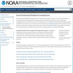
An FPSF incorporates strategically placed insulation to raise the frost depth around a building, thereby allowing foundation depths as shallow as 16 inches, even in the most severe climates (see comparison graphic). The most extensive use has been in the Nordic countries, where over one million FPSF homes have been constructed successfully over the last 40 years. Scandinavia considers FPSF a standard practice for residential buildings. Global-Scale Microwave Sounding Unit Temperatures. Regional Snowfall Index (RSI) Overview NOAA's National Centers for Environmental Information is now producing the Regional Snowfall Index (RSI) for significant snowstorms that impact the eastern two thirds of the U.S.

The RSI ranks snowstorm impacts on a scale from 1 to 5, similar to the Fujita scale for tornadoes or the Saffir-Simpson scale for hurricanes. The RSI differs from these other indices because it includes population. RSI is based on the spatial extent of the storm, the amount of snowfall, and the juxtaposition of these elements with population. Including population information ties the index to societal impacts. Six Easternmost Climate Regions The RSI is an evolution of the Northeast Snowfall Impact Scale (NESIS) which NCEI (then, NCDC) began producing operationally in 2005. The indices are calculated in a similar fashion to NESIS, but our experience has led us to propose a change in the methodology. U.S. Climate Extremes Index (CEI) Climate Data Online (CDO) <div id="scriptCookiesError" class="messageBlock msgError msgCookie"><div><p> Javascript has either been disabled or is not supported in your browser<br /><em>Some of this site's functionality requires Javascript to be enabled.
</em></p></div></div> The daily records summarized here are compiled from a subset of stations in the Global Historical Climatological Network. A station is defined as the complete daily weather records at a particular location, having a unique identifier in the GHCN-Daily dataset. Maine.gov: Residents: Records & Statistics. National Institutes of Health. NCHS - National Center for Health Statistics. CDC: Data & Statistics. Global Health Observatory data repository. Skip to main content Access Search Advanced search Navigation Language.
Insurance Institute for Highway Safety. Overview The number and types of motor vehicle crash deaths differ widely among the 50 states and the District of Columbia.
A state's population has an obvious effect on the number of motor vehicle deaths. Fatality rates per capita and per vehicle miles traveled provide a way of examining motor vehicle deaths relative to the population and amount of driving. However, many factors can affect these rates, including types of vehicles driven, travel speeds, rates of licensure, state traffic laws, emergency care capabilities, weather, and topography. The following facts are based on analysis of data from the U.S. Posted December 2019. United States Census Bureau. Sports Stats, fast, easy, and up-to-date. U. S. Department of Education.
State of Maine. County Health Rankings & Roadmaps. Stats of the State of Maine. * Rankings are from highest to lowest. ** Rates for the U.S. include the District of Columbia and (for births) U.S. territories.
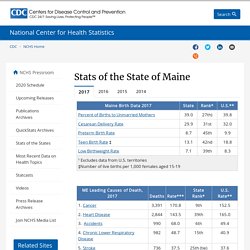
Refer to notes in publication tables for more detail. *** Death rates are age-adjusted. American FactFinder - Maine: Community Facts. Maine Economy at a Glance. 2019 Measures of Growth Report - Maine Development Foundation. MDF is pleased to release the 2019 Measures of Growth Report.
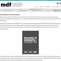
This annual report is produced in conjunction with the Maine Economic Growth Council (MEGC) and informs discussion on a variety of indicators that speak to Maine’s economic performance and the quality of life of Maine people. In total, the 2019 Measures of Growth Report tracks 27 indicators that collectively support the idea that Maine’s quality of life depends upon a vibrant and sustainable economy, thriving communities, and a healthy environment. Past performance and current conditions inform the establishment of future benchmarks for each indicator that are aspirational, potentially attainable and against which we can measure our collective progress. It is intended to serve as a guide to policymakers at all levels, a tool to help them focus their efforts, and a way to understand the connections between and among the major issues affecting the economy and well-being of Maine people. Census Bureau QuickFacts: Maine.