
California Center for Cooperative Development. CCA Officers. AEM Groups - Complete Group List. County Farm Bureau Details. TCFB - Board of Directors & Committees. Board of Directors In addition to the Executive Committee, the Tulare County Farm Bureau is governed by a Board of Directors.
The board meets monthly with the exception of two months out of the year, in July and December. Meetings are held on the 2nd Thursday, at 4:00 pm each month, at the TCFB Assembly Hall in Visalia, unless otherwise noticed. Members are always welcome to attend, but it is suggested you contact the office in advance for more information about each month's agenda.
Meet the 2014-15 Board... District 1 Representatives. County Farm Bureau Details. Los Angeles County Farm Bureau. Precision, Geospatial & Sensor Technologies Programs. Narrow profit margins, global competition, and attention to public goods have forced many producers, processors, and communities to carefully measure, monitor, micromanage resources to increase efficiency and overall benefit.
Through program leadership and grants, NIFA emphasizes the use of information and precision technologies to deliver decision tools that improve management capabilities for agricultural, food, forestry, and community enterprises. All precision agriculture activities have a number of things in common. First, data are collected with high, spatial and/or temporal resolution. Second, data are analyzed and related to treatments or manipulations that are specific in location and/or timing. Third, prescribed treatments are implemented using systems capable of precise control, tracking, or handling.
Detailed information about crop and site conditions was once inaccessible or prohibitively expensive to acquire. USDA Forest Service Global Positioning System: Home Page. Welcome to the Forest Service GPS Home Page This page provides GPS users a convenient source of Trimble Community Base Station GPS reference data as well as receiver performance reports, and links to GPS related information.
This page focuses on forestry related GPS mapping and GIS applications, both C/A code and P code, with emphasis on receiver operation under forest canopy and in backcountry/wildland environments for land management. MTDC Test Reports Differential Correction and Community Base Stations. Agricultural Applications. The development and implementation of precision agriculture or site-specific farming has been made possible by combining the Global Positioning System (GPS) and geographic information systems (GIS).
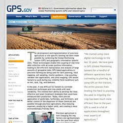
These technologies enable the coupling of real-time data collection with accurate position information, leading to the efficient manipulation and analysis of large amounts of geospatial data. Farm Equipment Center: Used farm tractors, farm machinery, and implements : Other vehicles. Agriculture. Ideag Group Farm Shows Home Page. Home - ARA Conference & Expo. About - Agricultural Retailers Association. Ag retailers supply farmers and ranchers with products and services.
These products include seed, nutrients, crop protection products, feed, equipment and technology. Retailers also provide consultative services such as crop scouting, soil testing, field mapping, custom planting and application and development of nutrient management and conservation plans. Certified Crop Advisors (CCAs) and Pest Control Advisors (PCAs) are often retained on the retailer’s staff to provide professional guidance and crop input recommendations to farmers and consumers. Agricultural retailers range in size from small, family-held businesses to large companies and farmer-owned cooperatives with many outlet stores.
Board of Trustees - CAST. Stakeholders - CAST. CAST. The Voice of Agriculture - American Farm Bureau. 2016 AFBF Annual Convention & IDEAg Trade Show. Corn, soybean, wheat fertility and crop management - Ag Professional. Do drones make sense for my corn fields? A company called Measure is trying to find out. Logan Bitz of South Country Equipment, which sells agriculture equipment, prepares to launch a PrecisionHawk drone.
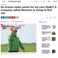
(Courtesy PrecisionHawk) Commercial drone flight could be legal in as soon as a year, and agriculture appears likely to be first to see the most significant impact. It’s a lot simpler and safer to fly a drone over a soybean field than to deliver a package in a crowded city. But for farmers questions remain over when and where flying drones is of value. The drone services company Measure is doing tests over cornfields in Raleigh, N.C. “There are cases where it may not make sense,” said Measure president Justin Oberman. . [7 insights from the FAA’s former leader on drones] The American Farm Bureau wants to quantify what sort of return farmers can expect when using drones. “Generally we’re convinced that it’s a technology that has a great deal of promise. Measure is testing with equipment from PrecisionHawk, which provides drones and data analysis for farmers.