
Google Map V3 Polygon Creator. Star Tutorial - Google Map API v3 polygon shape creator. Google Map V3 Polygon Creator. My Google Maps tool. Creating a polygon on googlemap and save the result to database using MVC. Edit this Fiddle. Shane Tomlinson. Gmaps-samples-v3.googlecode.com/svn/trunk/poly/poly_edit.html. Algoritmo del punto en un polígono en PHP. Ray-casting algorithm. Ray-casting algorithm You are encouraged to solve this task according to the task description, using any language you may know.
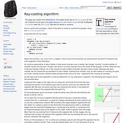
Given a point and a polygon, check if the point is inside or outside the polygon using the ray-casting algorithm. A pseudocode can be simply: count ← 0 foreach side in polygon: if ray_intersects_segment(P,side) then count ← count + 1 if is_odd(count) then return inside else return outside Where the function ray_intersects_segment return true if the horizontal ray starting from the point P intersects the side (segment), false otherwise. An intuitive explanation of why it works is that every time we cross a border, we change "country" (inside-outside, or outside-inside), but the last "country" we land on is surely outside (since the inside of the polygon is finite, while the ray continues towards infinity). So the main part of the algorithm is how we determine if a ray intersects a segment.
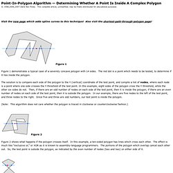
[edit] Ada polygons.ads: polygons.adb: Example use: main.adb: Output: [edit] C. Determining Whether A Point Is Inside A Complex Polygon. Point-In-Polygon Algorithm — Determining Whether A Point Is Inside A Complex Polygon © 1998,2006,2007 Darel Rex Finley.
This complete article, unmodified, may be freely distributed for educational purposes. Visit the new page which adds spline curves to this technique! Maps Javascript API V3 Reference - Google Maps JavaScript API v3. Release Version Last updated Monday, February 17, 2014 This reference documents version 3.15 (the release version) of the Maps Javascript API released November 15, 2013.
This release version of the API is a feature-stable version of the API whose interfaces are guaranteed to remain as documented within these pages until this version is retired. To consult the latest (experimental) version of the Maps Javascript API, see the Experimental Development Reference. Reference Table of Contents Map Controls. Complex polylines - Versión 3 del API de JavaScript de Google Maps. Google Maps api v3 enableEditing polylines - JavaScript. Drawing - google maps API v3 - how to draw dynamic polygons/polylines. Superposiciones - Versión 3 del API de JavaScript de Google Maps. Descripción general de las superposiciones Las superposiciones son objetos del mapa que están vinculados a coordenadas de latitud y longitud, por lo que se mueven al arrastrar el mapa o aplicar el zoom sobre él.
Las superposiciones son los objetos que "añades" al mapa para designar puntos, líneas, áreas o grupos de objetos. Google Maps API incorpora varios tipos de superposiciones: Los puntos en el mapa se muestran mediante marcadores. En algunas ocasiones, los marcadores pueden mostrar imágenes de iconos personalizados, que se denominan normalmente "iconos". Cómo añadir superposiciones Las superposiciones se suelen añadir al mapa en el momento de su creación; todas las superposiciones definen un objeto Options que se utiliza durante la creación y que permite designar el mapa en el que deben aparecer. // To add the marker to the map, call setMap();marker.setMap(map); Cómo eliminar superposiciones Si quieres administrar varias superposiciones, deberás crear un conjunto que las incluya todas.
Solving the Point in Polygon Problem Using Google Maps and Fusion Tables. As GeoSpatialpython.com mentioned, javascript based ray-casting is a good choice.
Here is a script from tparkin : It extends the google maps api v3 polygon class with a new method called containsLatLng which accepts a single LatLng object, which represents the point that you are actually checking against the polygon. To import a shapefile into Fusion Tables, use which is really easy to use. After you are done importing, you can see that the polygons, stored in your shapefile are now in your Fusion Tables table in KML format. Here comes the tricky part. If there is anything you don't understand or need help with, just shoot me a message here! [Google Maps API v3] Detect marker inside a polygon. Pour utiliser les Forums Google Groupes, activez JavaScript dans les paramètres de notre navigateur, puis actualisez cette page.
![[Google Maps API v3] Detect marker inside a polygon](http://cdn.pearltrees.com/s/pic/th/google-detect-polygon-groupes-63482331)
Nouveauté ! Réorganisez vos applications en faisant glisser les icônes. Connectez-vous pour essayer. Google maps - Determine the lat lngs of markers within a polygon. Google Map – Check whether a point (LatLong) exists within a polygon. The complete code is below the post.
Copy and paste the code in notepad , save the file with html extension and then run the file with any browser.I hope this post will be beneficial for the developers. Any feedback or comments are welcome. Complete Code: <script type="text/javascript" src=" var map; var boundaryPolygon; function initialize() { google.maps.Polygon.prototype.Contains = function (point) { // ray casting alogrithm var crossings = 0, path = this.getPath(); // for each edge for (var i = 0; i < path.getLength(); i++) { var a = path.getAt(i), j = i + 1;
Tparkin/Google-Maps-Point-in-Polygon.