
Architecture and Situated Technologies. View Flickr Photos in Google Earth. GPSTagr. ZoneTag Photos. Loc.alize.us - Explore your world through everyone's eyes. GPX. What is GPX?
GPX (the GPS Exchange Format) is a light-weight XML data format for the interchange of GPS data (waypoints, routes, and tracks) between applications and Web services on the Internet. Current Status The GPX 1.1 schema was released on August 9, 2004. GPX has been the de-facto XML standard for lightweight interchange of GPS data since the initial GPX 1.0 release in 2002. The JUMP Project. All about GIS. EasyGPS. Make your own annotated multimedia Google map. One of the great things about Google maps is it has its roots in XML.
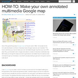
To translate for the non-web developers out there, it basically means Google maps are user hackable. This how-to will show you how to make your own annotated Google map from your own GPS data. Plus, you'll be able to tie in images and video to create an interactive multimedia map. We'll walk you through the steps we took to generate an annotated map of a walk we took recently through our hometown, now that it's actually starting to get warm enough to want to walk about! Background. GPS Visualizer. MapTools.org. Error, Accuracy, and Precision. U r b a n S i m u l a t i o n . c o m. FreeGIS. Digital Earth. Retooling the Global Positioning System. GPS Visualizer. Opensource GPS. Over the past 13 years I have been working off and on with a GPS receiver I built based on the GEC Plessy GP1010 and GP1020 chipset connected to an IBM PC which does all of the signal processing through I/O ports.
Recently I have converted the software for use with the Zarlink GP2021 and GP2010/2015 chipset. I am extremely grateful to GEC and Mitel who have allowed me to buy a small quantity of chips and have provided the documentation to go with them. This seems an appropriate time to offer the software as an open source in a manner similar to Linux. I hope this will provide a good starting point for others to build on. GPS. Dernière modification effectuée le 07/12/2018 à 10:11 Tout, ou presque sur les gps: Explications, Descriptions, Tests, Comparatifs, Lexique, Liens, Petites annonces, ect...
EGNOS? What is EGNOS?

The European Geostationary Navigation Overlay Service (EGNOS) is the first pan-European satellite navigation system. It augments the US GPS satellite navigation system and makes it suitable for safety critical applications such as flying aircraft or navigating ships through narrow channels. Consisting of three geostationary satellites and a network of ground stations, EGNOS achieves its aim by transmitting a signal containing information on the reliability and accuracy of the positioning signals sent out by GPS.
It allows users in Europe and beyond to determine their position to within 1.5 metres. EGNOS is a joint project of ESA, the European Commission and Eurocontrol, the European Organisation for the Safety of Air Navigation. Global Positioning System. Garmin Technical Information. This table contains a comparison of the various products in the Garmin handheld GPS line.
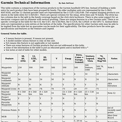
Instead of building a table entry for each product they have been grouped by family. The older multiplex units are represented by the G-38/G-40/G-45XL and the 12 channel parallel units are represented by the G-12/G-12XL/G48. The original mapping products are shown in the table entry for G-III/GIII+. There are special columns for the emap, etrex lines and 76 family. The etrex has two columns due to the split in the family coverage based on the click stick hardware. General Notes for table. Y means feature is present, N means not present. Notes: 1. 12CX is a 12XL except it has 2048 tracklog, 3 color display, 1000 waypoints, waypoint maintenance improvements, 35 hour battery life w/battery save, dedicated zoom keys, temperature 5 - 131 F 2.
Orbitica. Notes for GIS and The Geographer's Craft. Sample Examination and Study Questions Aerial Photography and Remote Sensing by Shannon Crum -- An introduction to the basic concepts of remote sensing, with emphasis on air photograph interpretation.
Also includes background on common satellite imaging systems. Application Areas Cartographic Communication by Kenneth E. Foote and Shannon Crum -- These notes include discussions of map elements, effective typography and symbolization, statistical generalization, and trends in computer-aided cartography. Coordinate Systems by Peter H. Data Sources by Kenneth E. Database Concepts: Issues of Modeling and Representation by Kenneth E. Navtech Seminars and GPS Supply.
Sam Wormley's Global Positioning System (GPS) Resources. Javad Navigation Systems. GPS precision. Doug's Home | Time | GPS | Photography | Internet | Software/Hardware | News/Finance | Consumer/Leisure | Volunteering | Genealogy.

MapCenter. GPSInformation.net. Global Positioning System Overview. Garmin International. Homebrew DGPS. I decided that I wanted a cheap low cost DGPS reciever so my solution is to build one. This project is just starting but is brought to you by: Jim Bixby Ready to build schematicsTim Hogard -- Keeper of messy notes & webmaster Larry Burg of Purple Computing. and the first sharehardware project. More to come.... The early ideas involved using a FGPA or the Skiper Chip by Pacific Crest but that seems oever complicated and the Skiper Chip hasn't been seen.
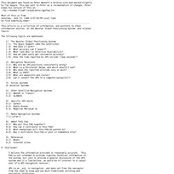
One of my posts. Using a GPS watch, XML, and satellite photos. This week's installment of "pt's how-to Friday" is a bit off the beaten path ???
Literally ??? But surprisingly enough, I've received a lot of emails about a project on my running for geeks web site, so I thought I'd show how I make high resolution maps of the places you jog, with the tracks overlaid on top. This is all possible using a GPS-enabled watch, called the Forerunner 201 from Garmin, the included software (Logbook) and a free application called USAPhotoMaps. GPS World.
Internet-based Global Differential GPS: Home. Sam Wormley's DGPS Resources. EUREF. GPS faq. This document was found on Peter Bennett's Archive site and edited slightly by Tim Hogard.
This was sent to Peter as a recomendation of changes. Peter keeps his version of this at: Most of this is from: Saturday, June 15, 1996 3:07:54 PM Local time So find something newer! Low Cost DGPS. The aim of this project is to produce a hardware and software solution to allow: Real time DGPS by transmitting error data via TCP/IP and other means. Post processed DGPS (ideal for surveying application).
The target budget for all the hardware (both the reference and roving station) is 600IRP. Software will be made available under GPL, LGPL or some similar open source licence. Global Positioning System Overview. DGPS over the Internet. GPS Drawing. WiFi ArT. Finisterrae's Cronotopo.