
All the software a geoscientist needs. [Updated 09 July 2014: Previous (2012) version for reference here.

Script updated for Ubuntu 14.04 based systems.] All of my research for the past 5 years was done with free software. In this post I describe the free programs that I use every day, and what I use them for. I do not use them simply to conform to stereotypes about cheap Scotsmen. As you will see, I use them because they are portable and very powerful.
Free/Libre Open Source Software (FLOSS) allows you to make as many copies the programs as you need and distribute them as you please. In this post, I have divided the programs into different categories: Operating system; Maps and Geographic Information Systems; Data Processing and Plotting; Writing Journal Articles; Conference Presentations; Programming Tools; Images, Graphics and Photos; Videos and Media; Computer Administration Tools and Miscellaneous. Operating System My current system runs a FLOSS operating system, GNU/Linux (shortened to Linux here). Programming Tools. OS and Freeware GIS Applications. An open source application by definition is software that you can freely access and modify the source code for.

Open source projects typically are worked on by a community of volunteer programmers. Open source GIS programs are based on different base programming languages. Three main groups of open source GIS (outside of web GIS) in terms of programming languages are: “C” languages, Java, and .NET. The first group would be the group that uses “C” language for its implementation. This is the more mature of the groups of open source GIS, probably for the simple reason that is the group that has been working on GIS software applications the longest and has a long history of resuse of code.
The second group of Open Source GIS would be the ones that use JAVA as the implementation language. The third most influential group of Open Source GIS would be the one that integrates applications that use “.NET” as the implementation language. Keep reading: 1 2 3 4 - , Next page >>. Generic Mapping Tools. Designing an OSM Map Style. With the recent change to our map system, we introduced a new map style for our OSM tiles.
Since 2008, we’ve used the default OSM styles, which produces map tiles like this: This style is extremely good at putting a lot of information in front of you. OSM doesn’t know your intended purpose for the maps (navigation, orientation, exploration, city planning, disaster response, etc.), so they err on the side of lots of information. This is good, but with the introduction of TileMill, non-professional cartographers (like myself) can now easily change map styles to better suit our needs. Using TileMill, we decided to take a crack at designing a map that is better suited to Flickr. On Flickr, we use maps for a very specific purpose: to provide context for a photo. This is the style provided by MapBox’s excellent OSM Bright. This is how it looks: We tried a lot of different color combinations on the road to this style.
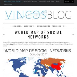
Here it is zoomed in a bit more: These maps are still a work in progress. Mapping Social Networks In A 3-D Environment. WorldMap of SocialNetworks. January 2017: a new edition of my World Map of Social Networks, showing the most popular social networking sites by country, according to Alexa & SimilarWeb traffic data (caveat: it’s hard to understand the impact of Google+ because it is part of Google domain traffic).

There are a lot of news since last January: Facebook is still the leading social network in 119 out of 149 countries analyzed, but it was stopped in 9 territories by Odnoklassniki, Vkontakte and Linkedin. It’s interesting to see that in some countries, like Botwana, Mozambique, Namibia, Iran e Indonesia, Instagram wins and that some African territories prefer LinkedIn. Overall LinkedIn conquers 9 countries, Instagram 7, meanwhile VKontakte and Odnoklassniki (part of the same group Mail.ru) grow up in Russian territories.
In China QZone still dominates the Asian landscape with 632 million users and Japan is the only country where Twitter is the leader. But what’s going on behind the first place? InShare1,047 inShare1,047. A Walk Through the Ancient World. When the first immersive 3D games came out, I asked a programmer if he knew of anyone who had used that technology to create a Virtual Ancient Rome or Virtual Ancient Athens.

I loved the idea of walking around in a place whose current face was changed out of all recognition from its golden age. He shook his head. Creating virtual worlds was way too time consuming and required too much specialist knowledge and so was too expensive. A virtual Rome wouldn't create the profit that Doom did. Fast forward a decade and the programming necessary becomes easier to do and the number of people who know how to do it have increased substantially. Now that it's quite a bit easier to find a virtual ancient city to stroll through, I thought I would survey a few options and provide you with a short virtual atlas of the ancient world.