
Innovative, interdisciplinary research in theory, methodology and computational tools. Statistical Standards and Guidelines. Skip to page content Statistical Standards and Guidelines The Statistical and Science Policy Branch in the Office of Information and Regulatory Affairs (OIRA) at the Office of Management and Budget (OMB) issues government-wide standards and guidelines to ensure comparability of Federal statistics.

OIRA issues guidance on information policy, the Privacy Act, and Federal information collection. Government-wide Standards and Guidelines Agency Standards and Guidelines. More adventures in overlay: point in polygon. Counting the number of points in a polygon is a common overlay operation.
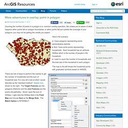
But unless you’re aware of what happens when points fall on polygon boundaries, or when points fall just outside the coverage of your polygons, you may not be getting the results you expect. Here’s the scenario: REDCAP: Regionalization with Constrained Clustering and Partitioning. The R Project for Statistical Computing. RGL - 3D Real-Time Visualization Device System for R. SaTScan - Software for the spatial, temporal, and space-time scan statistics. CrimeStat Spatial Statistics Program - Version 3.0.
Spatial Tools: Tobler's Flow Mapper.