
> <META NAME="description" CONTENT="After decades of using only one map projection, the Polyconic, for its mapping program, the U.S. Geological Survey (USGS) now uses several of the more common projections for its published maps. For larger scale ma. After decades of using only one map projection, the Polyconic, for its mapping program, the U.S.
Geological Survey (USGS) now uses several of the more common projections for its published maps. For larger scale maps, including topographic quadrangles and the State Base Map Series, conformal projections such as the Transverse Mercator and the Lambert Conformal Conic are used. Equal-area and equidistant projections appear in the National Atlas.
Other projections, such as the Miller Cylindrical and the Van der Grinten, are chosen occasionally for convenience, sometimes making use of existing base maps prepared by others. Some projections treat the Earth only as a sphere, others as either ellipsoid or sphere. Map Projections Poster. Map Projections: Contents. Cartography is the science of map-making.
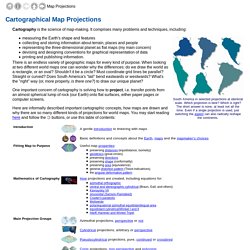
It comprises many problems and techniques, including: measuring the Earth's shape and features collecting and storing information about terrain, places and people representing the three-dimensional planet as flat maps (my main concern) devising and designing conventions for graphical representation of data printing and publishing information. There is an endless variety of geographic maps for every kind of purpose. When looking at two different world maps one can wonder why the differences: do we draw the world as a rectangle, or an oval?
Flex Projector.