
An Unity3d extension tool.
Documentation · vvoovv/blender-terrain Wiki. Introduction The addon imports digital elevation model (DEM) data from files in the SRTM format (.hgt).
The open terrain data set used by the addon provides global coverage. The data are prepared by Mapzen company and hosted at Amazon Web Services. Sample spacing for individual data points is 1 arc-second (roughly 30 meter) in latitude and longitude. Further information about the terrain data can found here. Please note, that the data license requires attribution as described here. blender-osm Take look at the addon blender-osm. Installation Download the latest version of the addon and install it via the usual Blender way (do not unpack the downloaded zip archive!) File → User Preferences... → Addons → Install from File...Find the file in your file system and press Install from File... buttonEnable the addon by checking the Enable an addon Preparation Donations If you find the addon useful, please consider making a donation: Usage Press Import Terrain button. Other import options Details. Working with Terrain Data.
Terrain or elevation data is useful for many GIS Analysis and it is often used in maps.
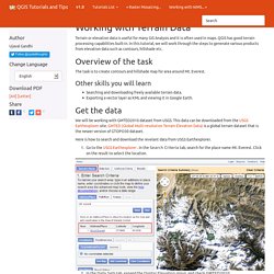
QGIS has good terrain processing capabilities built-in. In this tutorial, we will work through the steps to generate various products from elevation data such as contours, hillshade etc. Overview of the task The task is to create contours and hillshade map for area around Mt. Everest. Other skills you will learn Searching and downloading freely available terrain data.Exporting a vector layer as KML and viewing it in Google Earth. Get the data We will be working with GMTED2010 dataset from USGS. Here is how to search and download the revelant data from USGS Earthexplorer.
Go to the USGS Earthexplorer . In the Data Sets tab, expand the Digital Elevation group, and check GMTED2010. You can now skip to the Results tab and see the part of the dataset intersecting your search criteria. Select the 30 ARC SEC option and click Select Download Option. You will now have a file named GMTED2010N10E060_300.zip. Procedure. HGT File (What It Is & How To Open One) A file with the HGT file extension is a Shuttle Radar Topography Mission (SRTM) Data file.
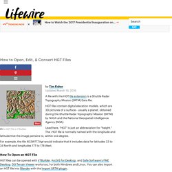
HGT files contain digital elevation models, which are 3D pictures of a surface - usually a planet, obtained during the Shuttle Radar Topography Mission (SRTM) by NASA and the National Geospatial-Intelligence Agency (NGA). Used here, "HGT" is just an abbreviation for "height. " The .HGT file is normally named with the longitude and latitude that the image pertains to, within one degree. For example, the file N33W177.hgt would indicate that it includes data for latitudes 33 to 34 North and longitudes 177 to 178 West. How To Open an HGT File HGT files can be opened with VTBuilder, ArcGIS for Desktop, and Safe Software's FME Desktop. Note: If you're using VTBuilder to open your HGT file, it's not done within the regular Open Project menu item.
See the Shuttle Radar Topography Mission home page, hosted by the NASA Jet Propulsion Laboratory, for all the basics on SRTM data, which comes in HGT format. Mapzen · start where you are. Developer overview. Mapzen’s products help you put a map anywhere, search and route the planet, and try a world of open data.

These are built from open-source tools that are packaged into a web service and hosted on Mapzen’s servers. If you want to use Mapzen’s services, you need to create a Mapzen developer account and a valid API key, and keep your requests to the service within certain rate limits. Developer accounts and API keys Mapzen developer account authentication is through GitHub, which is a website that enables people to collaborate on a project. You need to have a GitHub account to create a Mapzen developer account, as there is currently no other form of authentication. When signed in to your Mapzen developer account, you see a dashboard where you can create an API key, which is a code that uniquely identifies your developer account without providing a password. Mapzen’s web services have various API endpoints that allow you to access web resources through a URL.
Rate limits Check your usage. Feature Detection — OpenCV 2.4.13.2 documentation. Canny Finds edges in an image using the [Canny86] algorithm.
C++: void Canny(InputArray image, OutputArray edges, double threshold1, double threshold2, int apertureSize=3, bool L2gradient=false ) Python: cv2.Canny(image, threshold1, threshold2[, edges[, apertureSize[, L2gradient]]]) → edges C: void cvCanny(const CvArr* image, CvArr* edges, double threshold1, double threshold2, int aperture_size=3 ) ArcGIS Online. TerraServer - Aerial Photos & Satellite Images - The Leader In Online Imagery. Carte - Géoportail.
Terrain Tiles on AWS. Data is available in the "elevation-tiles-prod" Amazon S3 bucket.

There are several file formats for the data: Terrarium format PNG tiles contain raw elevation data in meters, in Mercator projection (EPSG:3857). All values are positive with a 32,768 offset, split into the red, green, and blue channels, with 16 bits of integer and 8 bits of fraction. To decode: (red * 256 + green + blue / 256) - 32768 Normal format PNG tiles are processed elevation data with the the red, green, and blue values corresponding to the direction the pixel “surface” is facing (its XYZ vector), in Mercator projection (EPSG:3857). Specifically, normal format alpha values are counted in (floored) elevation increments. Digital Elevation Model, DEMs, 3D Mapping.