
Navajo Parks & Recreation - Facility Rentals. Sommers-Bausch Observatory - University of Colorado. Outdoor Leadership Programs. Grizzly charge captured by B.C. filmmaker. To Our Faithful Current.com Users: Current's run has ended after eight exciting years on air and online.

The Current TV staff has appreciated your interest, support, participation and unflagging loyalty over the years. Your contributions helped make Current.com a vibrant place for discussing thousands of interesting stories, and your continued viewership motivated us to keep innovating and find new ways to reflect the voice of the people. We now welcome the on-air and digital presence of Al Jazeera America, a new news network committed to reporting on and investigating real stories affecting the lives of everyday Americans in every corner of the country. Star Trek: The Original Series: The 10 greatest episodes (+ video) - Amok Time. Vail Ski Resort, CO Trail or Piste Map : Google Earth Plugin : 3d Ski Maps. Route Description. Scott Shirey. Pikes Peak 02. Introduction This paper explains why and how atmospheric pressure decreases with altitude and discusses the variations in oxygen (O2) level that affect aerobic efficiency.
It is written mainly for runners of the Pikes Peak Ascent and Marathon but it applies to most any altitude race. The perspective is that of a meteorologist so the physiological processes of respiration are not covered here. What is covered are the answers to two specific questions: As I run on Pikes Peak, what is the typical change in the amount of available O2? Since the pressure at the top can change, what is the range of equivalent altitudes I may encounter at the top?
Answer to Question #1. PCT Thru-hike - Dehydration Recipes. Unique Technique We both subscribe to the "Keep It Simple, Stupid" philosophy and trail meals are no exception.
After a long day of hiking, who wants to fiddle with exotic ingredients, simmering, frying and all of that? We don't. 130410.JPG (650×488) Colorado Wilderness. Posted: May 11, 2012 by Sam Szarka Of the larger wilderness tracts in Colorado, the West Elk is perhaps the least well known.
Nevertheless, the visitor is offered scenic vistas of dark volcanic breccia worn into spires, towers, stone walls and castle-like formations of immense size. Long valleys and sun-dappled aspen forested slopes offer unique scenic beauty to the intrepid hiker. The West Elk wilderness is particularly well suited for alpine backpacking, as it offers unspoiled scenery, long ascending trails, and with no fourteeners, freedom from crowds. The northern portions of the wilderness contains the twin peaks, East and West Beckwith mountains, and the Anthracite Range.
The fifth largest wilderness in Colorado, the West Elk wilderness is located in the Gunnison National Forest. near the town of Gunnison, Colorado. Visiting the West Elk Wilderness. HowTo: Dehydrating Fresh Mushrooms. Cabbage rolls in the backcountry — sort of « backpacking recipes. April 8, 2009 by Laurie Ann I’m unsure of the original origins of this recipe.
It was given to me by my father-in-law after we had this for dinner at his home one evening. While it was a little different than the traditional cabbage rolls I was used to, I did enjoy it and I thought that it would dry perfectly. It did and it makes a great addition to our trail food. backcountry cabbage casserole dehydration time: 8 to 12 hours makes 4 to 6 servings If you are vegan you could easily substitute beef flavored TVP for the meat in the recipe. 1 pound ground beef 1 medium onion, finely chopped 1 cup cooked rice 2 10 oz cans condensed tomato soup salt and pepper, to taste 3 cups cabbage, shredded At Home Preheat oven to 350ºF.
Jambalaya with quinoa « backpacking recipes. Quinoa – A Superfood for the Trail « Food « Seattle Backpackers Magazine. Back in my vegetarian days I often turned to quinoa (pronounced keen-wa) as an important part of my diet.

Quinoa is the seed of the goosefoot plant which was prized by the ancient Incas. It is a complete protein and a good source of the amino acids. Quinoa is also gluten free. Quinoa isn’t just for vegetarians or people who can’t have gluten; it is a healthy and satisfying alternative to meat that everyone can enjoy – even the meat eaters among you. It makes an excellent protein for backpackers because you can cook it ahead of time, dehydrate it and rehydrate it on the trail. This food is also extremely versatile. Red Quinoa © Laurie Ann March. Leave No Trace. The USGS Store - One stop shop for all your maps, world, United States, state, wall decor, historic, planetary, topographic, trail, hiking, foreign, satellite, digital. Nearby Attractions - Great Sand Dunes National Park & Preserve. Zapata Falls flows into a narrow crevasse south of Great Sand Dunes National Park.
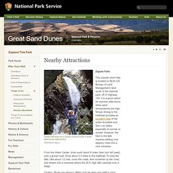
NPS/Patrick Myers Zapata Falls This popular short hike is located on BLM (US Bureau of Land Management) land south of the national park, off of Highway 150. Gear Talk with Jason Klass: Gear Storage and Packing. Purcell Trench grills. Purcell Trench manufacturing company home about order contact Grills: 1993 - 2014 Note: Shop will be closed March 27th for 5 or 6 weeks.
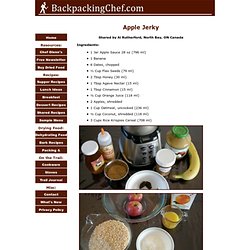
Trail Bytes - jeremiahmashore - Gmail. Al's Apple Jerky. Shared by Al Rutherford, North Bay, ON Canada Ingredients: 1 Jar Apple Sauce 28 oz (796 ml)1 Banana6 Dates, chopped⅓ Cup Flax Seeds (79 ml)2 Tbsp Honey (30 ml)1 Tbsp Agave Nectar (15 ml)1 Tbsp Cinnamon (15 ml)½ Cup Orange Juice (118 ml)2 Apples, shredded1 Cup Oatmeal, uncooked (236 ml)½ Cup Coconut, shredded (118 ml)3 Cups Rice Krispies Cereal (708 ml) At Home: Add apple sauce, chopped dates, banana, honey, cinnamon and flax seeds to blender.
US Forest Service, R2 Rocky Mountain Region - Colorado Hi-Speed Recreation Map. Welcome to the Hi-Speed Colorado Map!
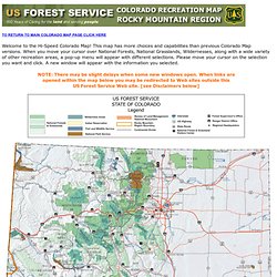
This map has more choices and capabilities than previous Colorado Map versions. When you move your cursor over National Forests, National Grasslands, Wildernesses, along with a wide variety of other recreation areas, a pop-up menu will appear with different selections. Please move your cursor on the selection you want and click. A new window will appear with the information you selected. Bb-tipperary_and_surprise_lakes_loop.pdf. Flat Tops : Climbing, Hiking & Mountaineering.
Overview The Flat Tops are more of a huge elevated plateau rather than a typical mountain range, but the plateau has been eroded into many individual peaks and summits, and most of them are flat-topped, or dome-like as are the Lost Lakes Peaks. The mountain area composing the Flat Tops contains over 110 lakes full of fish, and also has some of the most extensive areas above timberline in Colorado. Flat Tops Wilderness - General Information.
The United States Congress designated the Flat Tops Wilderness (map) in 1975 and it now has a total of 235,214 acres. All of this wilderness is located in Colorado and is managed by the Forest Service. Arthur Carhart's 1919 visit to Trappers Lake in the verdant embrace of the Flat Tops prompted him to be the first U.S. Forest Service official to initiate a plea for Wilderness preservation. North Derby and Hooper Lake Trails, Flat Tops Wilderness. Flat Tops Wilderness is the second largest U.S. Wilderness Area in Colorado. Located near the towns of Yampa and Steamboat Springs, it is 235,214 acres, with 38,870 acres in Routt National Forest and 196,344 acres in White River National Forest. The area is named for a series of flat top mountains that dominate the landscape. This is sub-alpine and alpine terrain with beautiful mountain ponds and lakes, rich evergreen forest, grassy marshes, and craggy tundra.
The elevation ranges from 7,600 to 13,000 feet. Hike Length: 8.7 miles Hike Duration: 7 hours. Earth Outreach. Google Earth makes it easy to create a map with annotations - you can add placemarks (points), paths (lines), polygons in Google Earth, and add text, images, and videos to the pop-up balloons. This tutorial uses Bristlecone Pine Tree research in the White Mountains as an example. The images and videos are from Adelia Barber's work at the White Mountain Research Center. Read more about her work in the Google Earth Outreach case study or on her website. This video demonstrates how to annotate Google Earth (1:19). Prerequisites Absolutely no programming skills needed! Recipes. FS09-3018.pdf. BackpackBaseCamp Blog. Experts in Adventure Cuisine! Freeze Dried and Dehydrated Food, and Cookware for Backpacking and Camping. Seven steps to lighten up. Guns not safer than bear spray in grizzly country, study finds. MyWeather - My Personalized Local Weather Forecast, Radar, and Storm Warnings.
Backpacking Food for the Soul. Hiking Knots - Introduction. Siberian Hitch Knot. Knots- siberian hitch, and adjustable grip hitch. Bushcraft - Farrimond v Cawley Hitch. Backpacks Infographic: How to Find the Right Backpack - REI. Day Forecast for Latitude 39.21°N and Longitude 105.46°W (Elev. 10860 ft) Colorado Backpackers (and Campers) Meetup Group (Denver, CO.