Soldes 2016 ! Des prix démentiels sur toutes nos gammes. 3D, réalité augmentée tourisme, patrimoine, formation. La Commission Européenne a décidé de soutenir le projet proposé par la Fondation « Route de la Libération de l’Europe » et ses partenaires dont l’agence 44 SCREENS visant à renforcer une offre transnationale sur le thème de la libération de l’Europe combinant les technologies de réalité augmentée, des m-visites de sites et de musées et des expériences nouvelles de tourisme de mémoire.
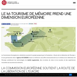
Le projet « Route de la Libération de l’Europe » offre pour la première fois une perceptive multinationale sur la fin de la Deuxième Guerre Mondiale. Il relie six pays traversés par les forces alliées occidentales, depuis le sud du Royaume-Uni jusqu’aux plages de Normandie et aux Ardennes belges, en passant par la province du Brabant, les villes d’Arnhem et de Nimègue, la forêt de Hürtgen ou encore Berlin. Il se poursuit également vers la ville de Dantzig, en Pologne, où une révolution démocratique visant à mettre fin à la division de l’Europe a eu lieu presque deux générations plus tard. Graphiste Freelance, infographiste 3D en Bretagne. ARTEFACTO - Réalité Augmentée.
Live Virtual Campus Tours, Destination Marketing. What is a Vicarious Experience?
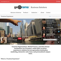
A vicarious experience provides the ability to virtually explore a destination in real-time via a guide. In a vicarious experience the guide is mobile and can move around freely, showing viewers what they see through a wearable camera. What’s more is that viewers can interact with the guide in real-time to control what they see, making it a highly personalized experience. How would it work? Georama provides its patent pending technology and services to enable robust, mobile, live streaming from a guide with a wearable camera to any website or device around the world.
Who would it involve? Georama can equip guides/representatives provided by your organization with the required technology. Where would the content live? Georama can integrate a fully customized solution into any existing website using a plug & play approach.
Beau site. Livre augmenté. Tool for Google Maps v3 (version 3) This application is also available with Large map.
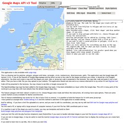
This is a drawing tool for polyline, polygon, polygon with holes, rectangle, circle, marker(icon), direction(route, path). This application uses the Google Maps API Version 3 (V3). It has all the features of Google Maps MyMaps and has direct access to the code for the shapes (overlays) you create. It should be a full-fledged alternative. You draw and create a map with the shapes you want. Code will be presented in the textarea. The OpenStreetMap map type has been added to the Google Maps map types. The feature 'polygon with hole' ('donut') is built-in in V3. The V2 feature enableEditing now exists for V3.
And for editing - if you have a kml file uploaded on a server, and you want to edit its coordinates, you may use my edit tool Edit tool for Google maps polyline and polygon You will need a PC or laptop with a large amount of computer memory if your kml file has 1000 coordinate pairs or more. Other useful links:
Image recognition. Guerre 1914-1918. TRACE. Pearltrees. Illustrations et cartes postales 14-18. Photographie feux d artifice. La Manif Pour Tous. Benoît XVI. Aidants. Epresence. CNP Assurances.