
Компоненти – GPS и локация. Php - Send current gps coordinates to mySQL database using google maps api. From Info Windows to a Database: Saving User-Added Form Data - Google Maps API. Abdulla Kamar, Google Maps API Team June 2009 Objective Many developers use the Google Maps API to create mashups that enable users to add and annotate geographically located information.
The most intuitive user interface for accomplishing that goal is to have the user first create a marker or poly, pop up a window with a form, then let the user fill out the form and press a 'save' button to close the info window. This is the method used, for instance, by Google's My Maps service. This tutorial will explain the concepts behind the HTML and JavaScript that make up the info-window editing user interface, as well as the PHP code that can be used to add the saved info window data into a MySQL database.
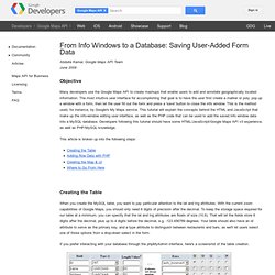
This article is broken up into the following steps: Creating the Table When you create the MySQL table, you want to pay particular attention to the lat and lng attributes. If you prefer interacting with your database through the phpMyAdmin interface, here's a screenshot of the table creation. <? Creating a Store Locator with PHP, MySQL & Google Maps - Google Maps API. Google Geo APIs TeamAugust 2009 This tutorial is intended for developers who are familiar with PHP/MySQL, and want to learn how to use Google Maps with a MySQL database to create a store locator-type app.
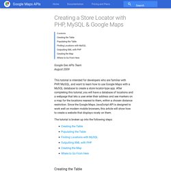
After completing this tutorial, you will have a database of locations and a webpage that lets a user enter their address and see markers on a map for the locations nearest to them, within a chosen distance restriction. Since the Google Maps JavaScript API is designed to work well on modern mobile browsers, this article will show how to create a website that displays nicely on them. The tutorial is broken up into the following steps: Creating the Table When you create the MySQL table, you want to pay particular attention to the lat and lng attributes.
Note: This tutorial uses location data that already have latitude and longitude information needed to plot corresponding markers. Populating the Table After creating the table, it's time to populate it with data. Finding Locations with MySQL <? Using PHP/MySQL with Google Maps - Google Maps API. Ben Appleton, Google Geo TeamWith contributions from Lary Stucker, Maps API DeveloperApril 2007 This tutorial is intended for developers who are familiar with PHP/MySQL, and want to learn how to use Google Maps with a MySQL database.

After completing this tutorial, you will have a Google Map based off a database of places. The map will differentiate between two types of places—restaurants and bars—by giving their markers distinguishing icons. An info window with name and address information will display above a marker when clicked. Geolocation - Google Maps API. Geolocation refers to the identification of the geographic location of a user or computing device via a variety of data collection mechanisms.
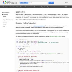
Typically, most geolocation services use network routing addresses or internal GPS devices to determine this location. Note that geolocation is a device-specific API; some browser/devices support it, while others do not (or cannot), so you cannot assume that geolocation is always possible for a web application. Detecting the User's Location Newer browsers are starting to support the W3C Geolocation standard. This standard is part of HTML5 and will likely become the de-facto standard going forward. Some browsers use IP addresses to detect a user's location. The following example attempts to determine the user's location through the W3C navigator.geolocation property. var initialLocation;var siberia = new google.maps.LatLng(60, 105);var newyork = new google.maps.LatLng(40.69847032728747, -73.9514422416687);var browserSupportFlag = new Boolean(); The Streaming APIs. Updated on Mon, 2012-09-24 14:47 Overview The set of streaming APIs offered by Twitter give developers low latency access to Twitter's global stream of Tweet data.
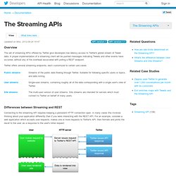
A proper implementation of a streaming client will be pushed messages indicating Tweets and other events have occurred, without any of the overhead associated with polling a REST endpoint. Twitter offers several streaming endpoints, each customized to certain use cases. Differences between Streaming and REST. API (twitterapi) How I get current location via GPS and don´t the (3g/wifi) network. V3: The Solution for Maps Applications for both the Desktop and Mobile Devices - Google Maps JavaScript API v3. The Maps JavaScript API lets you customize maps with your own content and imagery for display on web pages and mobile devices.
The Maps JavaScript API features four basic map types (roadmap, satellite, hybrid, and terrain) which you can modify using layers and styles, controls and events, and various services and libraries. Audience This documentation is designed for people familiar with JavaScript programming and object-oriented programming concepts. You should also be familiar with Google Maps from a user's point of view. There are many JavaScript tutorials available on the Web. Google Maps API Tutorial. Google Maps API Tutorial This tutorial is intended to help you create your own interactive maps using the Google API.
Do take a look at the Google documentation. There are two ways to use this tutorial: Read it and try to understand the principles involved. Use the example files as templates. What's New. Google Maps Events.