
Le choix difficile de la cartographie électronique. Which to choose ?
Raster ? Vector ? What costs, for which application, how to Navigation ? As many questions as most of you arise, and rightly. I will try to shed some light. While visiting my website pages devoted to charting (¹) on my website achieves the full information and links to various suppliers, a synthesis is needed here. First of all, specify the types of charting related to applications that concern us : PC-PLANNER Official WebSite.
Sailing milford haven europe english channel lundy. National Tidal and Sea Level Facility. Marine Weather. Marine Weather. Marine Weather. Shipping forecast and gale warnings - Marine weather. The shipping forecast is issued four times a day at 2300, 0500, 1100, 1700 UTC and covers a period of 24 hours from 0000, 0600, 1200 and 1800 UTC respectively.
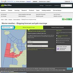
The waters around the British Isles are divided into 31 sea areas shown on the map. The forecast contains details of gale warnings in force, a general synopsis and sea-area forecasts containg forecast wind direction and force, weather and visibility. Gale warnings are issued as required throughout the day (for winds of Gale Force 8 or more). In the UK, the Maritime & Coastguard Agency (MCA) is responsible for the provision of Maritime Safety Information (MSI) to ships at sea, which includes the broadcast of warnings and forecasts.
The Met Office initiates warnings and prepares routine forecasts for dissemination on behalf of the MCA. Caution: The internet is not part of the Maritime Safety Information system and should never be relied upon as the only means to obtain the latest forecast and warning information. Trans-Atlantic Weather Forecasts/ Franks-Weather. Related pages On this page - Clearly, what you are able to get will depend largely on the equipment carried.
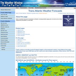
Long distance bluw water sailors that I know carry SSB radio (as both marine and radio amateur operators), Iridium phone, NAVTEX and INMARSAT. Irish Coast Guard. NOAA Charts PDF Format. Irish Sea Chart, Irish Sea Boating Charts. Maritime Safety Information. Admiralty Digital Products inc Total Tide, Digital List of Lights and Digital Radio Signals. Bainbridge Marine > Standard Outboard Hose Kits 100 PSI. Maritime Safety Information. 106jun. Maritime Safety Information. Pub161bk. Fishguard Harbour: Fishguard Harbour and Approaches Chart (2012): Visitmyharbour.com. GPS receiver. GPS receiver GPS receiver for position & navigation GPS receiver is customized to various interface.

(RS232,DB9,PS2,RJ11) Optional Voltage: 5~32V It is a highly sensitive USB GPS receiver with low power consumption. It is built with SiRF III GPS Chips architecture. It is very suitable for UMPC.Laptop.mobi [Product Details...] High sensitive personal GPS tracker XC-GT09 It is a high sensitivity and high quality personal GPS tracker. OsmAnd - Offline Mobile Maps and Navigation. OsmAnd Maps & Navigation. OsmAnd (OSM Automated Navigation Directions) est une application cartographique et de navigation avec accès aux données libres OpenStreetMap (OSM), à la couverture mondiale de haute qualité.
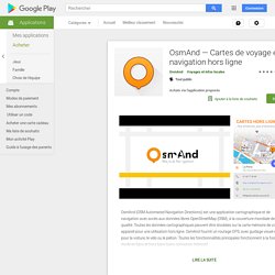
Toutes les données cartographiques peuvent être stockées sur la carte mémoire de votre appareil pour une utilisation hors ligne. OsmAnd fournit un routage GPS, avec guidage visuel et vocal, pour la voiture, le vélo ou le piéton. Toutes les fonctionnalités principales fonctionnent à la fois en mode en ligne et hors ligne (sans connexion Internet). Rivers & Seas - Das iPad-Navi für Flüsse, Seen und das Meer. De:Navigation program – OpenSeaMap-dev. Weather Observation Equipment by Peet Bros. Company Inc.:ULTIMETER Weather Stations:Weather Sensors.
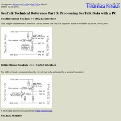
Thomas Knauf SeaTalk Technical Reference. Unidirectional SeaTalk => RS232 Interface This simple unidirectional interface circuit inverts the SeaTalk signal to make it readable by the PC serial port: Bidirectional SeaTalk <=> RS232 Interface For bidirectional communication the circuit has to be extended by a second transistor: A PC-board may be obtained from Frank Wallenwein.
The Marine Installer's Rant: Arduino weds Raspberry. The "Freeboard" project. "If you imagine it's possible, someone else is already trying to doing it, or has already done it.
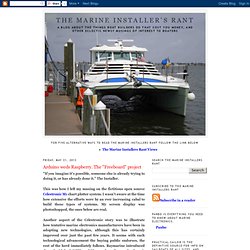
" The Installer. This was how I left my musing on the fictitious open source Celestronic M1 chart plotter system. I wasn't aware at the time how extensive the efforts were by an ever increasing cabal to build these types of systems. My screen display was photoshopped, the ones below are real. Another aspect of the Celestronic story was to illustrate how tentative marine electronics manufacturers have been in adopting new technologies, although this has certainly improved over just the past few years.
This all started with a somewhat cryptic comment left on the Celestronic post by "Practical Pirate. " The Raspberry Pi, receives that NMEA data from the Arduino or your current systems via USB, and does real time updating of browser pages accessible to PC's, tablets, and other mobile devices via WiFi. Now that we have met the Arduino, it's time to talk a bit about shields. De:Navigation program – OpenSeaMap-dev. Main Page – OpenSeaMap-dev. De:Bordnetz – OpenSeaMap-dev. Diese Seite beschreibt wie man Daten aus dem Bordnetz auf dem Laptop sammeln kann.
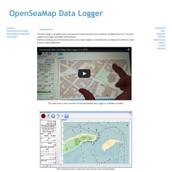
Die dringenste Frage ist meistens: Wie verbinde ich meine bestehende Infrastruktur mit dem Laptop/Smartphone. Die kurze Antwort ist: Jeder Hersteller verwendet unterschiedliche Stecker, kann aber meistens auch mit einem der standardisierten Protokolle umgehen. Welche Geräte wie am besten zu verbinden sind wird je nach Hersteller in den folgenden Abschnitten erläutert. Es wird erst auf die Computerschnittstellen eingegangen und dann auf die Schnittstellen des Bordnetzes, da diese unterschiedlich funktionieren. NMEA Java library. Introduction The Data Logger is an application to record and visualize ship data sent transfered via NMEA protocol.
It currently supports the widely used NMEA 0183 protocol. OpenSeaMap – Water Depths. How To Use Google Maps As Android Offline Maps In OruxMaps. RMaps is my favorite Android offline maps which allow download Google maps offline, this feature will benefit those who like to travel from getting lost and provide offline navigation.
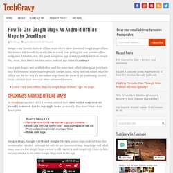
Unfortunately, this great navigation app already pulled down from Google Play Store, then i have use alternative android app called OruxMaps. I was quite happy and satisfied after used for some time, which allow make your own map by download online maps especially Google maps, as my android offline maps for offline use. By the way it’s also online map viewer let users to get positioning, record track, calculate land area and other advanced features. Garminkarten - Reit- und Wanderkarte. Die Karte ist in einer Version für Garmin GPS-Geräte zum Download verfügbar. Index of /maps. Interactive Catalog. NOAA ENCs (ENC): Vector files of chart features and available in S-57 format. NOAA ENCs support marine navigation by providing the official Electronic Navigational Chart used in ECDIS and in electronic charting systems. NOAA ENCs are updated weekly with Notice to Mariner corrections. Terms & Conditions NOAA Coast Pilot (CP): Nautical books that cover a variety of information important to navigators of coastal and intracoastal waters and the Great Lakes.
Issued in nine volumes, they contain supplemental information that is difficult to portray on a nautical chart. GPS - GPS32. WinNav / GPS-32 Produkte - GPS32. OpenNauticalChart. OpenNauticalChart. Raster Charts [Open Sea Chart] Free Vector Charts (ENC) [Open Sea Chart] Locus Map download. Locus Map - mobile outdoor navigation app. OpenSeaMap: Download chart. OpenSeaMap-charts can be used on board even without access to internet - with a chart plotter from Garmin, Lowrance, Simrad, B&G. Together with a navigation program or an app also with an onboard-computer, a notebook, on Android tablet, iPad or Windows tablet. Also with smartphones and some GPS-devices. List of devices. Nv charts – Android-appar på Google Play. A full Navigation Tool for Android Tablets and Phones and the best Navigation aid Tool for Sailors.
Navigation Data Visualize navigation data on your phone or tablet: position, SOG, COG, speed, heading, apparent wind, true wind, ground wind, VMG, Beaufort force, depth, water temperature, UTC time. (A NMEA 2000® or a NMEA 0183 WiFi adaptor is required to receive NMEA data. SeaWi decodes NMEA 2000® and NMEA 0183 data received in TPC, UDP Unicast and Multicast packets).
OruxMaps. Download free Mapsforge maps for Locus, OruxMaps, c:geo and more… Index of /maps/europe/great_britain. Index of /maps. Download free Mapsforge maps for Locus, OruxMaps, c:geo and more… Maps!!!! Details Written by Super User. United Kingdom Charts Available. Polar Navy - Marine Navigation Software. Raster Charts of Brazil. Land Information New Zealand (LINZ) MX Mariner. MX Mariner - Marine Navigation for Android MX Mariner is a basic mobile marine navigator / chart plotter featuring quilted offline marine charts. Raster marine charts published by NOAA (USA), LINZ (New Zealand) and Brazil Navy are available to install from within MX Mariner as free, downloadable regions. Once downloaded, each marine chart region is available for use offline. When online, a road map or satellite image map is alternatively available. UK chart regions are available for the United Kingdom, Ireland and Channel Islands as in-app purchases.
Matthew Eglin - March 4, 2013 - Version 1.3.23A great app I have used MX Mariner for 2 charters over the last few months. Todd Propes - January 21, 2013 - Motorola Droid RAZR with version 1.3.23Lifesaving Used this app. to navigate hundreds of miles down the intracoastal waterway in a sailboat. A Riopel - February 13, 2013 - Samsung Galaxy Nexus with version 1.3.23Excellent Support! Land Information New Zealand (LINZ)