
Astronomy. History. Geocache. The Degree Confluence Project. 37.771008, -122.41175 (You can insert your text here) - Google M. Geocaching. Geocaching /ˈdʒiːoʊˌkæʃɪŋ/ is an outdoor recreational activity, in which participants use a Global Positioning System (GPS) receiver or mobile device and other navigational techniques to hide and seek containers, called "geocaches" or "caches", anywhere in the world.
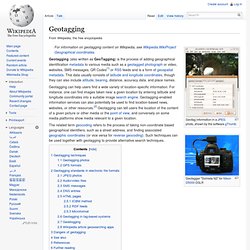
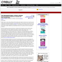
History[edit] This is where the very first geocache was placed by Dave Ulmer, 360° panorama view Dave Ulmer and the plaque commemorating the first geocache WikiMiniAtlas 45°17.460′N 122°24.800′W / 45.291000°N 122.413333°W / 45.291000; -122.413333. The activity was originally referred to as GPS stash hunt or gpsstashing. Over time, a variety of different hide and seek type activities have been created or abandoned, so that "geocaching" now may refer to hiding and seeking containers, or locations or information without containers.[8] Geocaches[edit] A classic geocache -- trade items in a military ammunition box Typical cache "treasures" are not high in monetary value but may hold personal value to the finder. Variations[edit] GeoTagging. Geotag information in a JPEG photo, shown by the software gThumb The related term geocoding refers to the process of taking non-coordinate based geographical identifiers, such as a street address, and finding associated geographic coordinates (or vice versa for reverse geocoding).
Such techniques can be used together with geotagging to provide alternative search techniques. Geotagging techniques[edit] The geographical location data used in geotagging will, in almost every case, be derived from the global positioning system, and based on a latitude/longitude-coordinate system that presents each location on the earth from 180° west through 180° east along the Equator and 90° north through 90° south along the prime meridian. [citation needed] Geotagging photos[edit] There are two main options for geotagging photos; capturing GPS information at the time the photo is taken or “attaching” the photograph to a map after the picture is taken.
GPS formats[edit] JPEG photos[edit] Audio/video files[edit] Google Maps Latitude, Longitude Popup. A Design Approach for the Geospatial We. By Julian Bleecker 06/07/2005 Editor's note: Julian Bleecker heads the Mobile Media Lab (MML), a near-future think tank and research and development lab at the University of Southern California. In today's article, Julian describes a design approach for location-based services utilized in many of the projects under way at MML.
At O'Reilly's Where 2.0 Conference later this month, Julian will be taking part in a panel discussion on the secrets behind good social mobile applications and the obstacles they face in the real world. Recently, Mike Liebhold wrote an essay that many regarded as a kind of manifesto for the location-based service (LBS) community.
In that prescient article, he describes what is needed to create a Geospatial Web, and what is necessary to sustain the promise of LBS as open and accessible, and a truly useful extension of what the World Wide Web currently offers. This coupling of the physical world with the data world represents an exciting and challenging new frontier. Google Maps. EarthExplorer. Geocoder.us: a free US address geocoder. O'Reilly Network: The Geospatial Web: A Call to Action. By Mike Liebhold, contributor to O'Reilly's upcoming Mapping Hacks 05/10/2005 Editor's note: In this article, Mike Liebhold writes about what we need to do to tap the as yet unharvested business opportunities in a geospatial web.
This is just the type of topic we'll be exploring at the O'Reilly conference Where 2.0, coming to San Francisco in late June. Join us to learn how vendors, application developers, and consumer web companies are using GPS, RFID, WLAN, cellular networks, and networked sensors in new ways to solve old business problems. Beyond a growing commercial interest in mobile GIS and location services, there's deep geek fascination with web mapping and location hacking. After several years of early experiments by a first generation of geohackers, locative media artists, and psychogeographers, a second, larger wave of hackers are demonstrating some amazing tricks with Google Maps, Flickr, and del.icio.us. 1. 2. Let's break this down into two parts. 3. 4. 5. 6. 7. 8. 9. Google Earth Community: Viewing list of forums.
Falling Rain Genomics: World Index, and other pages. Perry-Castañeda Library Map Collection - UT Library Online.