
Convergent Plate Boundaries—Accreted Terranes - Geology. Plate Tectonics & Our National Parks - Geology. Introduction The inspiring landscapes of the United States captivate with their beauty and power—and sometimes danger!
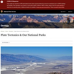
But the same geological forces that threaten our lives with earthquakes and volcanic eruptions also nourish our spirits by forming our country’s spectacular mountains, valleys, and coastlines. National parks, monuments and seashores highlight this scenery and reveal Earth’s processes in action. An area is established as a national park, monument, seashore, or other unit of the National Park Service because it displays something special about the cultural or natural history of the United States. East African Rift System is slowly breaking away, with Madagascar splitting into pieces. The African continent is slowly separating into several large and small tectonic blocks along the diverging East African Rift System, continuing to Madagascar -- the long island just off the coast of Southeast Africa -- that itself will also break apart into smaller islands.
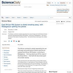
These developments will redefine Africa and the Indian Ocean. The finding comes in a new study by D. Downloads. Plate Tectonic Movements. Compiled by Jeff Crabaugh and John McDaris (SERC).
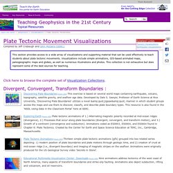
This section provides access to a wide array of visualizations and supporting material that can be used effectively to teach students about plate tectonic movements. Visualizations include simple animations, GIS-based animated maps, paleogeographic maps and globes, as well as numerous illustrations and photos. This collection is not exhaustive but does represent some of the best sources for teaching. Click here to browse the complete set of Visualization Collections. Divergent, Convergent, Transform Boundaries : Discovering Plate Boundaries (more info) This exercise is based on several world maps containing earthquake, volcano, topography, satellite gravity, and seafloor age data.
Exploring Earth (more info) Plate tectonic animations of 1.) Incorporated Research Institutions for Seismology. How were Earth’s layers discovered?
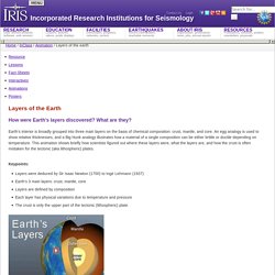
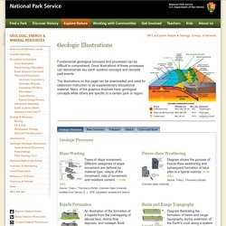
What are they? Earth’s interior is broadly grouped into three main layers on the basis of chemical composition: crust, mantle, and core. An egg analogy is used to show relative thicknesses, and a Big Hunk analogy illustrates how a material of a single composition can be either brittle or ductile depending on temperature. Basin & Range: Volcanoes- Incorporated Research Institutions for Seismology. Why is there such a variety of lavas in the Basin & Range province?
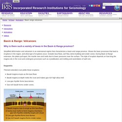
Simplified deformation and volcanism in an extensional regime that characterizes a basin and range province. Shows the basic processes that lead to eruptions in the region, and what type of eruptions occur. Includes lava flows, ash flow, dome building and cinder cones. During Basin & Range extension, the plates pull apart, the mantle rises and melts due to lower pressures near the surface. Basin & Range: GPS measures extension- Incorporated Research Institutions for Seismology. Basin & Range: Deformation, Erosion & Sedimentation- Incorporated Research Institutions for Seismology. Basin & Range: Structural Evolution- Incorporated Research Institutions for Seismology. How do basin and range mountains and valleys form?
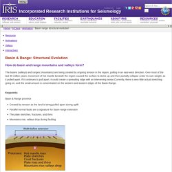
The basins (valleys) and ranges (mountains) are being created by ongoing tension in the region, pulling in an east-west direction. Video on Demand - Planet Earth - The Living Machine. Untitled. Lostcity05 massif. East African Rift. East African Rift Valley, Kenya : Image of the Day. Pillow lava. Pillow lavas are bulbous, spherical, or tubular lobes of lava.
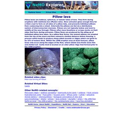
They form during eruptions with relatively low effusion rates. Slow extrusion gives enough time for a thick crust to form on all sides of a pillow lobe, and prevents individual pillows from coalescing into a sheet. GalAPAGoS: Where Ridge Meets Hotspot. Over time, the height, width and thickness of a chimney structure builds around the vent flow while the temperature and chemical composition of the hydrothermal fluid varies.
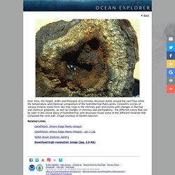
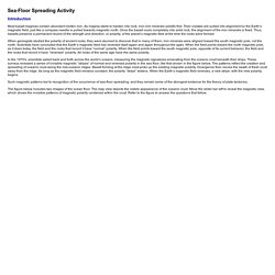
Concentric circles of various mineral zones form like tree rings in the chimney wall and evolve with changes in thermal and chemical gradients, as well as changes in chimney wall permeability. The different colors that can be seen in this sliced piece of hydrothermal vent structure reveal some of the different minerals that composed the vent wall. Image courtesy of Rachel Haymon. Related Links. Sea-Floor Spreading Activity. Introduction Most basalt magmas contain abundant molten iron.
As magma starts to harden into rock, iron-rich minerals solidify first. Their crystals are pulled into alignment by the Earth’s magnetic field, just like a compass needle is pulled towards magnetic north. Once the basalt cools completely into solid rock, the alignment of the iron minerals is fixed. Thus, basalts preserve a permanent record of the strength and direction, or polarity, of the planet’s magnetic field at the time the rocks were formed. Mid-Ocean Ridge Activity. Mid-Ocean Ridges. Magnetization of the Sea Floor and Seafloor Spreading Animation - Earthguide: Online Classroom. Tectonic Plates, diagrams redesign. Ccean crust. Geologic Resources » Education. Plate Tectonics Fault Types.
Geologic Resources » Education. Plate Tectonics: Shaping the Continents. Plate Boundaries: Divergent, Convergent, and Transform. Plate Movement: 200 Million Years Ago to Present Day. Educator Guide: Exploring Earthquakes. What are earthquakes? Get a new perspective on these powerful phenomena with our collection of videos and infographics co-produced with KQED, originally designed with middle and high school educators in mind. You and your students will learn why earthquakes happen, how they’ve shaped the Bay Area, and what you can do to prepare for the next one. We’ve included ideas for how to structure a sequence of learning tasks, but feel free to pick and choose! Whether you want to use the Exploring Earthquakes resources with students or to polish your own content knowledge, the following guide provides ideas for how to get started. Jumbo Seismic Monitor. Earthquake Browser. Plate Tectonics and California Geology. Gulf of California Tectonic Setting—Earthquakes & the Spreading Ridge.
Geology: North America's broken heart. Basalt cliffs along the St Croix River are remnants of rifting 1.1 billion years ago. On a bright October Saturday, the trees have reached their full autumn blaze at Interstate State Park on the border between Minnesota and Wisconsin in the US heartland. Crowds of people gawking at leaves thread their way along paths that wind through bulwarks of dark basalt, leading to views of the St Croix River.
Along one of the walkways, a photographer directs a young couple in coordinating grey shirts to lean against the rocks as she snaps a romantic portrait. If the two sweethearts are looking to commemorate their everlasting love, they should have picked a different backdrop. Appalachian_paleogeography_2_WEB. IRIS - Incorporated Research Institutions for Seismology. IRIS - Incorporated Research Institutions for Seismology.