
Transform Plate Boundaries - Geology. The Pacific Plate slides north-northwestward past the North American Plate along the San Andreas Transform Plate Boundary.
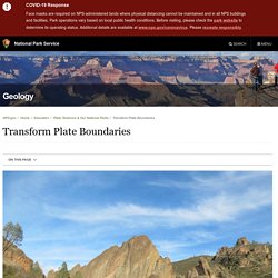
The San Andreas Fault is responsible for most of the movement in western California, causing a sliver of the state to slide past the rest of the continent. In Mexico, a combinatiion of divergent and transform plate boundary motion is opening the Gulf of California, causing the Baja Peninsula to separate from the rest of Mexico. Letters in ovals are abbreviations for NPS sites listed above. Modified from “Earth: Portrait of a Planet, by S. Marshak, 2001, W. Point Reyes National Seashore, Golden Gate National Recreation Area, and Pinnacles National Park present landscapes affected by the main line of movement, the San Andreas Fault.
The transform plate boundary between the Pacific and North American Plates in western California formed fairly recently. West Coast Tectonic Evolution. Mapping All 3,000 of Los Angeles's Active Oil Wells. Los Angeles is an oil town and it has been for a long time.

We know oil flows throughout LA in underground pipelines, that there is oil being extracted from under the Beverly Center right now, and that even pampered Beverly Hills High has a flowery, art-bedecked oil derrick (for now). But somehow the exact numbers are still surprising: there are now 3,000 active oil wells in LA County, says the LA Daily News. Would you like to know where they are? An interactive map created by the Division of Oil, Gas and Geothermal Resources of the California Department of Conservation allows users to locate all the wells in California, see who maintains each one, and view information about permits on the wells—way more transparent than the Skull-and-Bones-level secrecy surrounding pipelines.
(We highly recommend this page about how to work the map.) Los Angeles is an oil town and it has been for a long time. Map Data Map data ©2020 Google Los Angeles is an oil town and it has been for a long time. OilResearch. Supervolcanoes. San Jose State University Library. Oil Queen of California - American Oil & Gas Historical Society. A woman with a genius for affairs – it may sound paradoxical, but the fact exists.
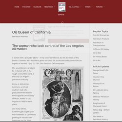
If Mrs. Emma A. Summers were less than a genius she could not, as she does today, control the Los Angeles oil markets. – July 21, 1901, San Francisco Call newspaper. Emma Summers’ business acumen put her in control of the Los Angeles City oil field’s production – and earned her oil queen title. She would become a lady to be reckoned with in the rough and tumble world of the early Los Angeles petroleum industry. Emma A. Like many others, Summers got caught up in the excitement of California’s growing oil industry. Once a struggling prospector, Doheny made his oilfield discovery near tar seeps. Chapter 4 Volcanism – Physical Geology. Back to the Future on the San Andreas Fault. Exposure of the San Andreas Fault in a trench.
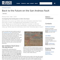
The horizontal colored lines highlight different layers of sediment. The red line is traced on a fault that offsets the layers. (Credit: Kate Scharer, USGS. Public domain.) Earth scientists have been gathering data at key paleoseismic sites along sections of the San Andreas Fault to figure out the past timeline of earthquakes at each spot. Geologic Formations - Joshua Tree National Park. The monzogranite developed a system of rectangular joints.
One set, oriented roughly horizontally, resulted from the removal—by erosion—of the miles of overlying rock, called gneiss (pronounced “nice”). Another set of joints is oriented vertically, roughly paralleling the contact of the monzogranite with its surrounding rocks. The third set is also vertical but cuts the second set at high angles. The resulting system of joints tended to develop rectangular blocks. (figure 1) Good examples of the joint system may be seen at Jumbo Rocks, Wonderland of Rocks, and Split Rock. As ground water percolated down through the monzogranite’s joint fractures, it began to transform some hard mineral grains along its path into soft clay, while it loosened and freed grains resistant to solution.
Antarctica8. Gicima. Fs022 00. Volcano Hazards of the Lassen Volcanic National Park Area, California. U.S.
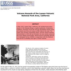
Geological Survey Fact Sheet 022-00 Online version 1.0 On the night of May 19, 1915, the few people homesteading outside of Old Station along Hat Creek near the foot of Lassen Peak, a volcano in northern California, went to bed expecting a peaceful night’s sleep. By now they had become accustomed to the sounds of small steam explosions coming from the volcano, which had been intermittently active during the past year. Around midnight, Elmer Sorahan was awakened by his dog barking furiously and pawing him. Dressing quickly, Elmer went outside, expecting a bear or other animal. How Old is "Cinder Cone"?—Solving a Mystery in Lassen Volcanic Park, California.
U.S.
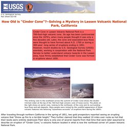
Geological Survey Fact Sheet 023-00 How Old is "Cinder Cone"? –Solving a Mystery in Lassen Volcanic National Park, California After traveling through northern California in the spring of 1851, two gold prospectors reported seeing an erupting volcano that “threw up fire to a terrible height.” They further claimed that they walked 10 miles over rocks so hot that their boots were entirely destroyed.Their story is only one of several reports from that time that were later assumed to describe an eruption of “Cinder Cone,” a volcanic feature located in what is now the northeast corner of Lassen Volcanic National Park.
Cinder Cone is a 700-foot-high cone of loose scoria. There are actually two scoria cones at Cinder Cone—the remnants of a nearly completely buried earlier cone can be seen on the larger cone’s south side. Beginnings of a Controversy The circumstances surrounding these reports are somewhat obscure and inconsistent. Early Geologic Studies New Geologic Studies. Fs2014 3119 2.