
LiDAR USA. GoLook The GoLook camera system combines seven (7) 1080p HD video cameras capturing 30fps into a synchronized, calibrated photogrammetric video imaging system.
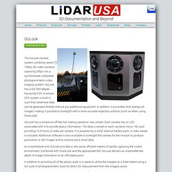
GoLook has a full 360 degree horizontal FOV. Feature Extraction Software to position and measure physical features - Zoom Information Systems. ZOOM in conjunction with itssister company Lambda Tech International, is pleased to offer the GPSVision™ system.
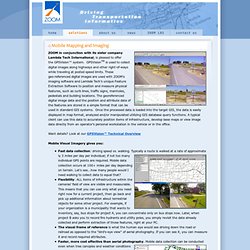
GPSVisionTM is used to collect digital images along highways and other right-of-ways while traveling at posted speed limits. These geo-referenced digital images are used with ZOOM's imaging software and Lambda Tech’s unique Feature Extraction Software to position and measure physical features, such as curb lines, traffic signs, manholes, pedestals and building locations. The georeferenced digital image data and the position and attribute data of the features are stored in a simple format that can be used in standard GIS systems. Once the processed data is loaded into the target GIS, the data is easily displayed in map format, analyzed and/or manipulated utilizing GIS database query functions. Fast data collection: driving speed vs. walking. Agine the enhanced perception!
GeoNav Group International: Providing guidance in geospatial technology. Bjørn K Nilssen - Fasadepanorama fra Kristiansand. COMOS Walkinside - Plant Engineering Software. E-ideas Co.,Ltd-GIS Solution for you business. FlyAbout: Spatially Indexed Panoramic Video. Don Kimber and Jonathan Foote FX Palo Alto Laboratory, Inc. 3400 Hillview Ave.
Bldg 4 Palo Alto, CA 94304 {kimber,foote}@pal.xerox.com Surapong Lertsithichai Harvard Design School 48 Quincy Street Cambridge, MA 02138 surapong@post.harvard.edu In Proc. Making Video Clips Interactive in Adobe Flash CS5 - Flash. Flash has been a popular conduit for video delivery over the web for quite some time, and in-spite of the rumblings about Flash's future as a web delivery tool, with the growth of HTML5 and mobile devices it will continue to be popular for some time yet I think.
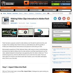
Most people's experience of Flash delivered video is with using on-screen controls like play and pause that might be sitting under the video window or perhaps superimposed over the video, slightly transparent and perhaps only appearing when the video is rolled over. This is all well and good if you intend to offer this level of user control from the outset.
There are other options for how the user interacts with video however, and in this article I will explore what I think is one of the best. .: Imatronics :. Empowering Intelligence. Samples -- Including High Definition Video Samples -- (***Please scroll down for more samples***) Interactive Video - Professional interactive video virtual tours made easy Feature Demonstrations – Browser-contained and Self-contained Samples ***Please note that you need a relatively powerful computer, a powerful graphics card and a fast Internet connection for a smooth viewing experience.
The local (self-contained) versions of the samples usually offer better performance because there is no need for Internet data streaming for the local versions. Chrome Experiments - Arcade Fire. The Wilderness Downtown Choreographed windows, interactive flocking, custom rendered maps, real-time compositing, procedural drawing, 3D canvas rendering... this Chrome Experiment has them all.

"The Wilderness Downtown" is an interactive interpretation of Arcade Fire's song "We Used To Wait" and was built entirely with the latest open web technologies, including HTML5 video, audio, and canvas. HTML5 Canvas 3D engine renders a flocking bird simulation that reacts to the music and mouse. HTML5 audio plays music and keeps track of timecode. Sequence system controls and synchronises effects and windows to the timecode.
HTML5 video plays film clips in custom sizes. Choreographed windows are triggered by the music and placed relative to screen size. Tutorials. Hang gliding with GPS data / Google Maps overlay - Hang Gliding Org - Worlds largest Hang Gliding community, discover Hang Gliding. Data and Map overlay GoPro video (html5/javascript) » Go HTML 5. LineVision Viewer - Remote GeoSystems. Sample_flash_4000kbps. Www. Playing back video in sync with GPS tracking. Once you've got time-stamped GPS information, don't rely on justsetInterval or setTimeout to manage the timing.
If there are any delays,those functions will cause the delays to accumulate and slowly causesynchronisation to be lost. Use Date.getTime() to get a reference time at the start and calculateall the delays relative to that time. For example, suppose you've just processed an event that was supposed tohappen at 5000 milliseconds, and the next event is supposed to happen at6000 milliseconds. Don't just perform a setTimeout to delay for 1000milliseconds. // Make a note of the time when the whole thing starts var start = new Date(); // To schedule an event to occur at timestamp "T" ms var now = new Date(); var delay = T - now.getTime() + start.getTime(); // Check to see if we're already too late if (delay > 0) { setTimeout("nextEvent()", delay); } else { nextEvent(); } Street View Video Driving Directions. One of the problems with biking directions in Google Maps is that you are never entirely sure how safe the biking route is before setting off.
For example, whenever I use biking directions around my home Google Maps usually suggests roads I would never consider cycling on and ignores far safer and quieter roads. Cyclodeo helps solve this problem by letting you view a video of a suggested cycling route before you undertake your journey. The application uses Google Maps and videos of a cycling route to allow the user to view the route before setting out.
The videos are synced to the Google Map of the route so the user can click anywhere on the route and view the video at that location. Untitled. 10 Examples Using The New Google Maps API For Flash. Until now Google Maps via the Flash platform hasn’t been available unless you’ve been using the the UMAP component from AFComponents.
Map of the Week - 360 Degree Panoramic Video Linked to Google Maps. Camera Module. Diy - OEM Camera Sensors for a computer project - Photography Stack Exchange. EVM Camera Board - Leopard Imaging Inc. ADC Optical Filter Evaluation System. The camera's image sensor's output is optimized for receipt of wavelengths around approximately 800nm dropping in a smooth curve to 20% peak output at 450 nm in the visible spectrum and 1050 nm in the near-infrared at the limits of its range.
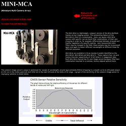
A graph of the sensitivity of the camera's image sensor to impinging radiation is shown below. By choosing a specific narrow band optical filter that is within the sensor's range to place in front of each channel's image sensor, the radiation that is able to reach each sensor may be restricted to a specific narrow band of wavelengths. In this way, specific filter combinations may be selected that allow the Mini-MCA to expose differences between stressed and healthy vegetation (see example graph below), individual plant species, different stages of growth of a single species or to determine the presence or absence of a specific chemical compound identifiable by its own unique spectral signature.
- TAN2008001_Multiple_Camera_Arrays.pdf. Synchronizing image acquisition of multiple PGR cameras. - TAN2009001_Creating_OEM_Multi_Cam_Array.pdf. Point Grey Research Insights - January 2009. Throwable Panoramic Ball Camera // Jonas Pfeil. Photo Sphere – About – Google Maps. Photo Sphere, Google Maps and Google Business Photos. Google enables you to build your own street view. Google Street View, as everyone knows, provides panoramic views from positions along many streets in the world. It was launched way back in 2007, started with several cities in the United States, and has since expanded to include cities and rural areas worldwide. In recent times, even it has accomplished capturing Venice, Italy, and at various mountains, parks ect. And now, Google is offering tailor made street view as well, meaning, it enable us to build our own street view.
It can create a virtual tour of your business to attract customers or it can also helps you capturing your favorite places with 360 degrees virtual tour. Hmmmmm… sounds interesting??? You only need to just take photo spheres and connect them to create 360º virtual tours of the places you love, then share them with the world on Google Maps. For more details, you may visit here, here and here as well. Woww !!! About The Author.