

Victoria Falls. Naming[edit] David Livingstone gazing upon the Falls, in bronze, from the Zambian shore.

David Livingstone, the Scottish missionary and explorer, is believed to have been the first European to view Victoria Falls on 16 November 1855 from what is now known as Livingstone Island, one of two land masses in the middle of the river, immediately upstream from the falls on the Zambian side.[1] Livingstone named his discovery in honour of Queen Victoria, but the indigenous name, Mosi-oa-Tunya—"the smoke that thunders"—continues in common usage as well. The nearby national park in Zambia, for example, is named Mosi-oa-Tunya,[2] whereas the national park and town on the Zimbabwean shore are both named Victoria Falls.[3][4] The World Heritage List officially recognizes both names.[5] In 2013 the government of Zimbabwe declared its intention to officially rename the falls "Mosi-oa-Tunya", citing continuity with other renamings such as Harare (from Salisbury), and Zimbabwe (from Rhodesia).[6] Falls.
Parícutin. Parícutin (or Volcán de Parícutin, also accented Paricutín) is a cinder cone volcano in the Mexican state of Michoacán, close to a lava-covered village of the same name.
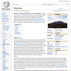
The volcano is unique in the fact that its evolution from creation to extinction was witnessed, observed and studied. It appears on many versions of the Seven Natural Wonders of the World. Parícutin is part of the Michoacán–Guanajuato volcanic field, which covers much of west central Mexico. It is part of the Ring of Fire. History[edit] Three weeks before the actual eruption, rumbling noises that resembled thunder were heard by people near Parícutin village. At the end of this phase, after roughly one year, the volcano had grown 336 metres (1,102 feet) tall. Volcanism is a common part of the Mexican landscape. Shots of the volcano during its active phase were included in 20th Century Fox's film Captain from Castile, released in 1947.
Aurora (astronomy) Natural light display that occurs in the sky, primarily at high latitudes (near the Arctic and Antarctic) Images of auroras from around the world, including those with rarer red and blue lights Aurora australis from the ISS, 2017.
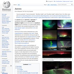
Video of this encounter: [2] An aurora (plural: auroras or aurorae),[a] sometimes referred to as polar lights, northern lights (aurora borealis), or southern lights (aurora australis), is a natural light display in the Earth's sky, predominantly seen in the high-latitude regions (around the Arctic and Antarctic). Auroras are the result of disturbances in the magnetosphere caused by solar wind. The resulting ionization and excitation of atmospheric constituents emit light of varying color and complexity. Etymology[edit] Occurrence[edit] A geomagnetic storm causes the auroral ovals (north and south) to expand, bringing the aurora to lower latitudes. North America Eurasia Images[edit] Mount Everest. Everest from space Mount Everest (also known in Nepal as Sagarmatha and in Tibet as Chomolungma) is the Earth's highest mountain.
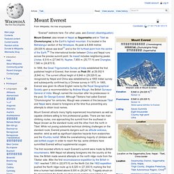
It is located in the Mahalangur section of the Himalayas. Its peak is 8,848 metres (29,029 ft) above sea level[1] and is the 5th furthest point from the centre of the Earth.[6] The international border between China and Nepal runs across the precise summit point. Its massif includes neighboring peaks Lhotse, 8,516 m (27,940 ft); Nuptse, 7,855 m (25,771 ft) and Changtse, 7,580 m (24,870 ft). Rio de Janeiro. Great Barrier Reef. The Great Barrier Reef is the world's largest coral reef system[1][2] composed of over 2,900 individual reefs[3] and 900 islands stretching for over 2,300 kilometres (1,400 mi) over an area of approximately 344,400 square kilometres (133,000 sq mi).[4][5] The reef is located in the Coral Sea, off the coast of Queensland, Australia.
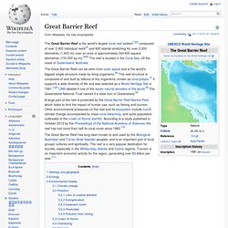
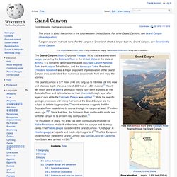
The Great Barrier Reef can be seen from outer space and is the world's biggest single structure made by living organisms.[6] This reef structure is composed of and built by billions of tiny organisms, known as coral polyps.[7] It supports a wide diversity of life and was selected as a World Heritage Site in 1981.[1][2] CNN labeled it one of the seven natural wonders of the world.[8] The Queensland National Trust named it a state icon of Queensland.[9] Grand Canyon. View from the South Rim The Grand Canyon (Hopi: Ongtupqa; Yavapai: Wi:kaʼi:la) is a steep-sided canyon carved by the Colorado River in the United States in the state of Arizona.
It is contained within and managed by Grand Canyon National Park, the Hualapai Tribal Nation, and the Havasupai Tribe. President Theodore Roosevelt was a major proponent of preservation of the Grand Canyon area, and visited it on numerous occasions to hunt and enjoy the scenery. For thousands of years, the area has been continuously inhabited by Native Americans who built settlements within the canyon and its many caves.
The Pueblo people considered the Grand Canyon ("Ongtupqa" in Hopi language) a holy site and made pilgrimages to it.[7] The first European known to have viewed the Grand Canyon was García López de Cárdenas from Spain, who arrived in 1540.[8] Geography[edit]