
Remembering Pearl Harbor: The USS Arizona Memorial. Today the battle-scarred, submerged remains of the battleship USS Arizona rest on the silt of Pearl Harbor, just as they settled on December 7, 1941.
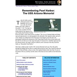
The ship was one of many casualties from the deadly attack by the Japanese on a quiet Sunday that President Franklin Roosevelt called "a date which will live in infamy. " Home/IWitness:Video testimonies from Holocaust survivors and witnesses. Powers of Persuasion. Photos of World War II Ships. An Overview of the Holocaust: Topics to Teach. How Vast was the Crime. Gabor Neumann Photo Gallery “And so, within seven months, I lost my father, my brother, and my mother.
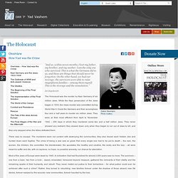
I am the only one who survived. This is what the Germans did to us, and these are things that should never be forgotten. On the other hand, we had our revenge: the survivors were able to raise magnificent families – among them myself. Site Overview. This site was created to bring us face-to-face with those who experienced the World War II internment of Japanese Americans - a critical part of 20th century American history still largely unknown.

Here, more than two dozen short video clips from some of the best films available on the subject are featured along with brief historical text and images to illuminate the people, places, voices and circumstances that are part of this history. (Please see the Help page for software requirements and troubleshooting in viewing clips.) Three broad sections present a chronological overview of internment and it's impact. We highly recommend browsing through the site chronologically, starting with the World War II and Roundup section: Each of these sections contains 7 - 10 pages which focus on key historical events or themes related to internment. Versailles Gallerie des glaces - Panoramiques 360 -panorama photo-360 degree QTVR.
Copyright @ Hans Nyberg - panoramas.dk · www.qtvr.dk · www.360-foto.dk · www.virtualdenmark.dk · Privacy Policy I panoramas.dk is hosted by: VRWAY Important info about Copyright: All panoramas featured at panoramas.dk are copyright the individual photographers.

Linking directly to the movies Quicktime or Flash is strictly forbidden. If you which to use any of the panoramas for any purpose, commercial or editorial you are requested to contact the photographer who has the copyright and is listed on all fullscreen pages. Links to panoramas.dk are welcome. You are allowed linking directly to the panoramapages using a small screenshot as long as it is used directly as a link or associated with a link . Animated WW2 Map Europe. GERMAN EXPANSION 1933 – The Nazi Party came to power in Germany (the Third Reich forms).
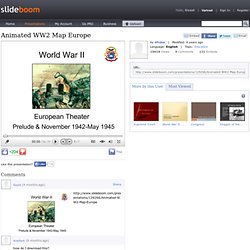
Hitler began to rebuild the military in direct violation of the Treaty of Versailles (secretly at first, and in public by 1935 – the Western democracies do nothing). March 1936 – Germans occupied the Rhineland with troops – again violating the Treaty of Versailles and again resulting in no reaction from the Western democracies. March 1938 – Austria was annexed by the Third Reich. Sept 1938 – Munich Agreement. Educational History Games. Propaganda Posters.
Each of the nations which participated in World War One from 1914-18 used propaganda posters not only as a means of justifying involvement to their own populace, but also as a means of procuring men, money and resources to sustain the military campaign.
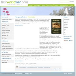
In countries such as Britain the use of propaganda posters was readily understandable: in 1914 she only possessed a professional army and did not have in place a policy of national service, as was standard in other major nations such as France and Germany. How war stories inspire children to learn. 12 February 2012Last updated at 00:58 For many school pupils, the dramatic events of WWI and WWII have not been solely learned through studying dusty history textbooks.

Many fictional tales of loyalty and survival - often based on true wartime events - have also helped children to understand what happened. At Imperial War Museum North in Greater Manchester, a new exhibition - Once Upon a Wartime - celebrates novels that have helped youngsters engage with the battlefield horrors and domestic hardships at times of conflict. Dr Geoff Fox is one of the exhibition's advisers. Spatial History Project. About this Visualization This animation is intended to be used as a tool for exploring the historical evolution and geographical context of one of the Nazis' chief systems of exploitation and control: the concentration camps administered by the SS.
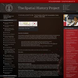
The spatial and temporal patterns revealed in this visualization raise questions that we hope will spur further inquiry. These include (but are certainly not limited to): How was the location of camps related to resources and territorial control? Why did some camps exist only briefly while others lasted for years? We invite you to explore these patterns and share your own observations. Data notes: History - World Wars: Animated Map: The Western Front, 1914 - 1918. History: World Wars in-depth.