
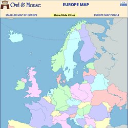
Interactive Map of Europe, Europe Map with Countries and Seas. Europe is the second smallest of the inhabited continents.
It is a part of the Eurasian land mass that includes Europe, Asia, Asia Minor and the Arabian Peninsula. As many large islands east and south of Asia are usually included in Asia, the Eurasian land mass extends from Iceland to New Guinea, from the Atlantic to the Pacific and from the Arctic to the Indian Oceans.
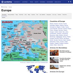
Europe. Map of Europe, European Maps, Countries, Landforms, Rivers, and Geography Information. Europe History As for Europe, a brief chronological account of its significant events begins during prehistoric times with the emergence of Homo sapiens (early man), roughly 40,000 years ago.
Early inhabitants during the Paleolithic Age, in an effort to survive, grouped together into small societies such as bands, and subsisted by gathering plants and hunting for wild animals. The practice of cultivating the soil, producing crops and raising livestock began in the Neolithic Age some 9,000 years ago; stone tools were used and people began to live in small groups, or villages. As man continued to journey east-to-west across Eurasia (a combination of Asia and Europe), knowledge of tools and new methods of organization arrived; civilizations flourished as metal axes and arrowheads improved survival. In the 8th century BC, Greece began to emerge from the Dark Ages.