
Maps.stamen.com. Converting Large Panoramic Images to PhotoOverlays for Google Earth. By David Martin, Jeffrey Martin, and the 360Cities Team Outline Introduction You are probably already familiar with medium of 360 degree panoramic images from either Google Street View or KML PhotoOverlays in Google Earth (from the Gigapxl, Gigapan, or 360Cities layers).
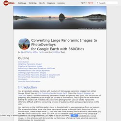
Tools for authoring panoramic images are getting very good, but the process of preparing and presenting such images on the web is still difficult. That is part of the motivation behind the creation of 360cities.net: panoramic photographers use our site to replace the otherwise difficult and time-consuming process of publishing their geotagged panoramas to the web. Converting Large Panoramic Images to PhotoOverlays for Google Earth. By David Martin, Jeffrey Martin, and the 360Cities Team Outline Introduction You are probably already familiar with medium of 360 degree panoramic images from either Google Street View or KML PhotoOverlays in Google Earth (from the Gigapxl, Gigapan, or 360Cities layers).

Tools for authoring panoramic images are getting very good, but the process of preparing and presenting such images on the web is still difficult. That is part of the motivation behind the creation of 360cities.net: panoramic photographers use our site to replace the otherwise difficult and time-consuming process of publishing their geotagged panoramas to the web. You can turn on the 360Cities gallery layer in Google Earth to view panoramas from our system. Google Earth Screenshots (click to view larger images) What is a Panoramic Image?
A panoramic image is the ultimate wide angle image. Because a panoramic image shows you what the world looks like from a single viewpoint, it is shaped like a sphere. Conclusion. Explore Styles - Snazzy Maps - Free Styles for Google Maps. Earth Outreach. Embedding New Google Maps. The all new Google Maps was made openly available to the public back in July, but it's still a preview of what the final product will be and therefore lacks a few familiar features.
For example, have you tried to embed a newer Google map into a web page? The reliable old "link" button is nowhere to be found! Some folk will suggest you revert back to the old Google Maps, embed an iframe in the original way, then shift back to the newer Maps preview once you're done. But there's another way, and it's a way which will help you take advantage of the newer, prettier Google Maps, like this: Maps Engine Lite (Beta) is a tool which allows you to design and save your own custom maps. You can then publish and share your maps, so let's begin by clicking on "New map": Sun Surveyor shines with Street View. In this guest blog post, we hear from Adam Ratana, a hobbyist photographer and software engineer by day, and developer of the Android and iOS Sun Surveyor apps by night.
In this tutorial, Adam talks about his creative implementation of custom polylines on Street View panoramas in the Google Maps SDK for iOS. When I set out to build Sun Surveyor, I knew I wanted to give users an easy way of visualizing the location of the sun and the moon. Sun Surveyor has an augmented reality (AR) feature, which overlays sun and moon paths on top of the device camera’s view. This is useful for understanding how light will change over time at a particular location. Tour Builder.
Google Maps API - More Than A Map. StreetView Tile generator. Yeah, creating panoramas is not like writing code, you'd need a decent camera and panorama-stitching software to get nice panoramas.
I personally like hugin.sf.net but haven't tried many, it takes a while to pick reference points even though the software makes it very easy. For best results: - use a tripod, preferably with a panning head - use a bubble level to keep the camera pointing flat - shoot in vertical format (not landscape) for lesser optical distortion and better vertical coverage Sorry for the off-topic, this is more related to photography than to the API, but those tips were not obvious before lots of trial and frustration, so I'd figure I'd share them :) Cheers, Miguel - mostrar texto citado - Hi,I want to use the v3 API to create my own little StreetView.Is there any tool available to create tiles for street view from a panorama?