
CARTO · idealista public feed. Walkalytics. Geoportal IDEE. Lista de Servicios Web de Mapas (WMS) que cumplen la especificación WMS 1.1.0 o superior, del Open Geospatial Consortium, de modo que son estándar e interoperables: Andalucía (305) Junta de Andalucía (305) Agencia Andaluza de la Energía (1) Consejería de Fomento y Vivienda (2)
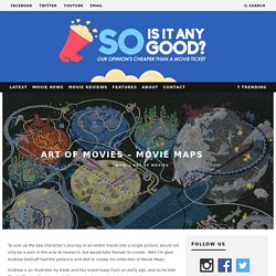
Gizmodo. The History of Barcelona, in 26 Interactive Maps. It’s now possible to flip through the key chapters of Barcelona’s life as a city, through the The Historic Charter of Barcelona.
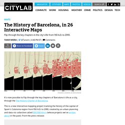
This is a new interactive mapping project tracking the history of the capital of Spain’s Catalonia region from 150 A.D. to 2010, created by an urban-planning and data-viz collective called 300.000 Km/s (whose projects we’ve written about in the past). From the press release: The Historic Charter of Barcelona is a pioneering tool in the research and dissemination of urban history, making Barcelona the first city in the world to have a tool of this complexity.
The Historic Charter is a document aiming to study the history but also to explain it: a tool to think the future by understanding the past. This project presents 24 maps, each representing a different milestone in the city’s growth over time. This gif shows an abridged version of that transformation: La salvaje destrucción de Londres por los bombardeos nazis, explicada en mapas. Reino Unido fue uno de los pocos países europeos no invandidos por la Alemania de Hitler durante la Segunda Guerra Mundial.
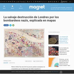
No fue por su falta de ambición, sino por su incapacidad logística y militar de hacerlo. Sin embargo, eso no impidió que el país sufriera en sus carnes la brutalidad inédita del conflicto. Lo hizo a través de los incesantes bombardeos que, durante toda la guerra, pero especialmente entre 1940 y 1941, los bombarderos de la Luftwaffe destrozaron la ciudad y mataron a alrededor de 30.000 personas. Naturalmente, el alcance de la destrucción londinense fue muy menor al encontrado en otras ciudades europeas a la altura de 1945 (Varsovia, Budapest o Berlín, de la que hablamos aquí, habían sido derribadas en su práctica totalidad). Pero eso no significa que sus cicatrices no fueran grandes ni visibles. CityChrone.
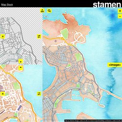
Map Stack / Edit. Map Stack.
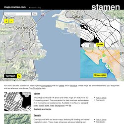
Chatty Maps. ART OF MOVIES - Movie Maps. To sum up the key character’s journey in an entire movie into a single picture, would not only be a pain in the arse to research, but would take forever to create.
Well I’m glad Andrew DeGraff had the patience and skill to create his collection of Movie Maps. Andrew is an illustrator by trade and has loved maps from an early age, and as he told The Huffington Post, it sounds like merging his passion of stories and maps was a no brainer: “When I started as a professional illustrator, I got a few jobs creating maps for travel magazine illustrations, and had a lot of fun doing them. I realized I really loved doing architecture and landscape. At the time I was also showing in some pop-culture shows, and I noticed that a lot of the work was based on character portraits, characters in scenes, or the characters re-contextualized.
I’ve included some examples of his work below but for more of Andrew’s illustrations check out his website and tumblr page. Urban Age. Pixel Map Generator. Mapnificent - Dynamic Public Transport Travel Time Maps. «Lo importante de un mapa no es lo que muestra, es lo que esconde» Maps.stamen.com. For over a decade, Stamen has been exploring cartography with our clients and in research.
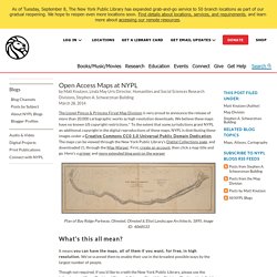
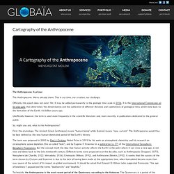
These maps are presented here for your enjoyment and use wherever you display OpenStreetMap data. Toner These high-contrast B+W (black and white) maps are featured in our Dotspotting project. They are perfect for data mashups and exploring river meanders and coastal zones. Open Access Maps at NYPL. The Lionel Pincus & Princess Firyal Map Division is very proud to announce the release of more than 20,000 cartographic works as high resolution downloads.
We believe these maps have no known US copyright restrictions.* To the extent that some jurisdictions grant NYPL an additional copyright in the digital reproductions of these maps, NYPL is distributing these images under a Creative Commons CC0 1.0 Universal Public Domain Dedication. The maps can be viewed through the New York Public Library’s Digital Collections page, and downloaded (!)
, through the Map Warper. First, create an account, then click a map title and go. Here’s a primer and more extended blog post on the warper. ¿Podría Twitter ayudar a planificar las vías de transporte? The Mapping London Blog. Appealing Industries: Animated History Of NYC Subway. Language communities of Twitter (European detail) A Cartography of the Anthropocene. The Anthropocene: A primer.
The Anthropocene. We’re already there. This is our time, our creation, our challenge. Officially, this epoch does not exist. Yet. Unofficially however, the term is used more frequently in the scientific literature and, more recently, in publications dedicated to the general public. So, might you ask, what is the Anthropocene? First, the etymology. The term was proposed in 2000 by Paul J. Technically, the Anthropocene is the most recent period of the Quaternary, succeding to the Holocene.
ES:Beginners Guide. Introducción OpenStreetMap (OSM) sigue un concepto similar a Wikipedia, pero para los mapas y otros datos geográficos (a pesar de su nombre, no significa que esté limitado solo a los nombres de las calles y carreteras).
La gente, como usted y yo, recoge datos de lugares por todo el mundo usando una variedad de recursos que van desde los dispositivos GPS, fotografías aéreas de libre uso o simplemente del buen conocimiento de la zona porque vive allí. The Geotaggers' World Atlas: un álbum de Flickr. #rorschmap. Ocupación del espacio público II. Tranquila, con gente que se mueve al ritmo del dia a dia, edificios y espacios públicos bien cuidados… todo parece estar en su sitio...
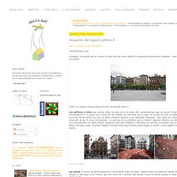
¿EN SU SITIO? Let's describe the whole world! IkiMap, comparte tus mapas. Generate a panorama. Restriction of maximum width to 14400 Pixel (= horizontal extension 360° with zoom factor 2) 14.05.2011 - In recent days, the requests have increased massively to this application. As a consequence, sometimes there result long times of waiting for the panoramas to appear. Very broad panoramas bind disproportionate resources. Therefore I have restricted the maximum width of the full panoramas to allow the fairest possible sharing of the limited resources. The restriction does not apply to the panoramas sent by e-mail. This restriction allows the creation of full 360-degree panoramas with zoom factor 2. The application runs on a home computer with a quad processor and 4 MB memory, connected to the outside world with DSL 6000, i.e. outbound with max. 750 bits/s, on which my son also is playing FIFA11 and so on.
So I ask you for your understanding that nothing will change without your contribution. Mapa de los carteles de la droga en México. (2)