NOS Special Projects - NOAA Historical Shoreline Survey Viewer
What is a Shoreline Survey? Shoreline surveys (also called coastal surveys, T-Sheets or TP-Sheets, and shoreline manuscripts) refer to topographic sheets compiled from maps derived in the field with a plane table, in the office from aerial photos, or a combination of the two methods. These shoreline surveys are the authoritative definition of the U.S. high-water line and may also include details such as roads, prominent buildings, and other features along the coast. The surveys were used as base maps to construct nautical charts primarily used for navigation.
Carte de L'Amerique Septentrionale Pour servir a L'Histoire de la Nouvelle France.: Geographicus Rare Antique Maps
Carte de L'Amerique Septentrionale Pour servir a L'Histoire de la Nouvelle France. 1743 (dated) 11.25 x 14.25 in (28.575 x 36.195 cm) 1 : 27073000 An important and influential first edition first state 1743 map of the North America by the French cartographer Jacques-Nicholas Bellin. Bellin's map covers all of North America from the Arctic to the Spanish Main, including modern day Canada, the United States, Mexico, Central America, and the West Indies. The map features several interesting annotations throughout.
Enduring Voices Project, Endangered Languages, Map, Facts, Photos, Videos
Explore Talking Dictionaries The Enduring Voices team is pleased to present these Talking Dictionaries, giving listeners around the world a chance to hear some of the most little-known sounds of human speech. Several communities are now offering the online record of their language to be shared by any interested person around the world. While you probably won't walk away from these Talking Dictionaries knowing how to speak a new language, you will encounter fascinating and beautiful sounds--forms of human speech you've never heard before--and through them, get a further glimpse into the rich diversity of culture and experience that humans have created in every part of the globe.
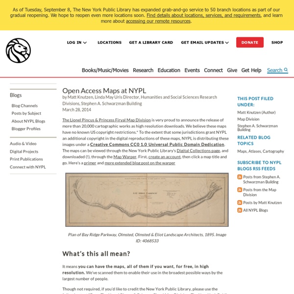
‘The Earth is, in fact, round’ - Medieval manuscripts blog
It’s a major peeve of many medieval historians: the popular belief that people who lived before Christopher Columbus thought that the world was flat. It is actually rare to find groups in the classical, Late Antique and medieval eras who believed in the flat Earth. On the contrary, numerous ancient thinkers, navigators and artists observed that the Earth was round. Miniature of the Earth in a circle, with personifications of the four cardinal points, made in England in the 3rd quarter of the 13th century: Egerton MS 843, f. 23r
Map: Vaccine-Preventable Outbreaks
This interactive map visually plots global outbreaks of measles, mumps, whooping cough, polio, rubella, and other diseases that are easily preventable by inexpensive and effective vaccines. Red triangles indicate attacks on vaccinators and healthcare workers, as well as announcements from both governments and non-state actors that have had an impact—either positive or negative—on the successful implementation of vaccination programs. The Global Health Program at the Council on Foreign Relations has been tracking reports by news media, governments, and the global health community on these outbreaks since the fall of 2008. This project aims to promote awareness of a global health problem that is easily preventable, and examine the factors that threaten the success of eradicating preventable illnesses such as polio. Learn more about Global Health.
mapFAST
mapFAST Find library materials about world wide locations Find FAST Geographic Subject Headings Near: Terms of Use