
Tutorial: Fundamentals of Remote SensingMicrowave remote sensing - Airborne versus Spaceborne Radars. Like other remote sensing systems, an imaging radar sensor may be carried on either an airborne or spaceborne platform.
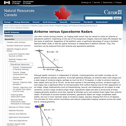
Depending on the use of the prospective imagery, there are trade-offs between the two types of platforms. Regardless of the platform used, a significant advantage of using a Synthetic Aperture Radar (SAR) is that the spatial resolution is independent of platform altitude. NASA Remote Sensing Tutorial. Landsat Education offers a wide range of resources, including Landsat images, animations, K-14 classroom exercises, data tutorials, fact sheets, and more.
We encourage you to contact us with your questions and feedback and to share your ideas about using Landsat for learning and teaching. Additionally, NASAWavelength.org is a digital collection of NASA Earth and space science resources for educators of all levels – from elementary to college, to out-of-school programs. These resources, developed through funding of the NASA Science Mission Directorate (SMD), have undergone a peer-review process through which educators and scientists ensure the content is accurate and useful in an educational setting. Use NASA Wavelength to quickly and easily locate resources, create your own collections within NASA Wavelength, connect them to other websites using atom feeds, and even share resources through social media.
For Students. Geometry of Aerial Photography. I.
Classification of Photographs In his book on aerial photo interpretation, Paine presents a dichotomous key for classifying aerial photography. The key is listed as follows: Photographs.